


<< Our Photo Pages >> Skåltegn Lilleborg - Rock Art in Denmark in Bornholm
Submitted by Boeddel on Sunday, 08 April 2018 Page Views: 1010
Rock ArtSite Name: Skåltegn LilleborgCountry: Denmark County: Bornholm Type: Rock Art
Nearest Town: Aakirkeby
Latitude: 55.118918N Longitude: 14.897236E
Condition:
| 5 | Perfect |
| 4 | Almost Perfect |
| 3 | Reasonable but with some damage |
| 2 | Ruined but still recognisable as an ancient site |
| 1 | Pretty much destroyed, possibly visible as crop marks |
| 0 | No data. |
| -1 | Completely destroyed |
| 5 | Superb |
| 4 | Good |
| 3 | Ordinary |
| 2 | Not Good |
| 1 | Awful |
| 0 | No data. |
| 5 | Can be driven to, probably with disabled access |
| 4 | Short walk on a footpath |
| 3 | Requiring a bit more of a walk |
| 2 | A long walk |
| 1 | In the middle of nowhere, a nightmare to find |
| 0 | No data. |
| 5 | co-ordinates taken by GPS or official recorded co-ordinates |
| 4 | co-ordinates scaled from a detailed map |
| 3 | co-ordinates scaled from a bad map |
| 2 | co-ordinates of the nearest village |
| 1 | co-ordinates of the nearest town |
| 0 | no data |
Internal Links:
External Links:
I have visited· I would like to visit
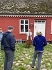
Boeddel visited on 4th Apr 2018 - their rating: Amb: 5 Access: 4 Not only the cup marks, but also the beautiful castle ruins are worth a visit.
")
Cup marks on a cliff block at the ruined castle Lilleborg.
You may be viewing yesterday's version of this page. To see the most up to date information please register for a free account.
")
")
")
Do not use the above information on other web sites or publications without permission of the contributor.
Nearby Images from Flickr

The above images may not be of the site on this page, but were taken nearby. They are loaded from Flickr so please click on them for image credits.
Click here to see more info for this site
Nearby sites
Click here to view sites on an interactive map of the areaKey: Red: member's photo, Blue: 3rd party photo, Yellow: other image, Green: no photo - please go there and take one, Grey: site destroyed
Download sites to:
KML (Google Earth)
GPX (GPS waypoints)
CSV (Garmin/Navman)
CSV (Excel)
To unlock full downloads you need to sign up as a Contributory Member. Otherwise downloads are limited to 50 sites.
Turn off the page maps and other distractions
Nearby sites listing. In the following links * = Image available
392m NE 50° Hammershøj Mindedysse* Modern Stone Circle etc
800m N 352° Rokkestenen i Almindingen* Natural Stone / Erratic / Other Natural Feature
817m SE 136° Gamleborg i Almindingen* Hillfort
1.1km NNW 346° Vestermarie Vildtbanesten* Marker Stone
1.3km N 355° Lovrup Skov Vildtbanesten* Marker Stone
1.3km W 280° Arboretet Bautasten* Modern Stone Circle etc
1.6km SSW 191° Ekkodalen Skåltegn* Rock Art
1.6km N 2° Koldekilde Bautasten 1* Standing Stone (Menhir)
1.7km N 0° Koldekilde Bautasten 2* Standing Stone (Menhir)
1.8km SSW 193° Loeklippen Skåltegn 1* Rock Art
1.8km SSW 193° Loeklippen Skåltegn 2* Rock Art
1.8km SSW 194° Loeklippen Skåltegn 3* Rock Art
2.9km SSW 210° Dyrsten Sagnsten* Natural Stone / Erratic / Other Natural Feature
3.2km WSW 250° Galgebakken i Vestermarie Plantage* Cairn
3.3km WSW 248° Skibssætninger i Vestermarie Plantage* Cairn
3.6km SSW 196° Lykkegaard Bautasten* Standing Stone (Menhir)
4.4km W 270° Lille Bjergegårdsbakken* Standing Stones
4.5km S 187° Tvillingsgård Bautasten* Standing Stone (Menhir)
4.6km W 269° St. Bjergegårdsbakken* Standing Stones
4.8km WSW 252° Vestermariestenen 6* Sculptured Stone
4.8km WSW 252° Vestermariestenen 5* Sculptured Stone
4.8km WSW 252° Vestermariestenen 4* Sculptured Stone
4.8km WSW 252° Vestermariestenen 3* Sculptured Stone
4.8km WSW 252° Vestermariestenen 2* Sculptured Stone
4.8km WSW 252° Vestermariestenen 1* Sculptured Stone
View more nearby sites and additional images


 We would like to know more about this location. Please feel free to add a brief description and any relevant information in your own language.
 Wir möchten mehr über diese Stätte erfahren. Bitte zögern Sie nicht, eine kurze Beschreibung und relevante Informationen in Deutsch hinzuzufügen.
 Nous aimerions en savoir encore un peu sur les lieux. S'il vous plaît n'hesitez pas à ajouter une courte description et tous les renseignements pertinents dans votre propre langue.
 Quisieramos informarnos un poco más de las lugares. No dude en añadir una breve descripción y otros datos relevantes en su propio idioma.