


<< Our Photo Pages >> Green Plain settlement - Ancient Village or Settlement in England in Yorkshire (North)
Submitted by rogerkread on Sunday, 21 May 2017 Page Views: 1761
Multi-periodSite Name: Green Plain settlementCountry: England County: Yorkshire (North) Type: Ancient Village or Settlement
Nearest Town: Otley Nearest Village: Blubberhouses
Map Ref: SE14925378
Latitude: 53.979867N Longitude: 1.773991W
Condition:
| 5 | Perfect |
| 4 | Almost Perfect |
| 3 | Reasonable but with some damage |
| 2 | Ruined but still recognisable as an ancient site |
| 1 | Pretty much destroyed, possibly visible as crop marks |
| 0 | No data. |
| -1 | Completely destroyed |
| 5 | Superb |
| 4 | Good |
| 3 | Ordinary |
| 2 | Not Good |
| 1 | Awful |
| 0 | No data. |
| 5 | Can be driven to, probably with disabled access |
| 4 | Short walk on a footpath |
| 3 | Requiring a bit more of a walk |
| 2 | A long walk |
| 1 | In the middle of nowhere, a nightmare to find |
| 0 | No data. |
| 5 | co-ordinates taken by GPS or official recorded co-ordinates |
| 4 | co-ordinates scaled from a detailed map |
| 3 | co-ordinates scaled from a bad map |
| 2 | co-ordinates of the nearest village |
| 1 | co-ordinates of the nearest town |
| 0 | no data |
Internal Links:
External Links:
I have visited· I would like to visit
RantonUFO SumDoood would like to visit
")
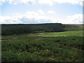
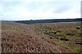
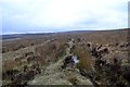
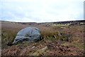
On the banks of Sun Bank Gill and with at least one spring in the area, so well sited, though it is all fairly bleak moorland these days. Just upstream is a large and curiously shaped boulder, the Eagle Stone, with potential cup marks on top, though these could be natural. Both sites are marked on Ordnance Survey maps.
For more information see The Northern Antiquarian's entry for Green Plain, Blubberhouses Moor, North Yorkshire, which gives directions for finding the site, together with a 1946 ground-plan, photographs and a brief archaeology & history.
Pastscape Monument No. 50461 also records this site, summarising it a "Two irregular-shaped enclosures of boulder walling - possibly denuded sheepfolds or plausibly an Iron Age settlement", adding these are: "two irregular-shaped enclosures each about 30.0m by 20.0m and formed in the main by random boulder walling up to 0.8m high, although in at least one place there is evidence of coursing. One of the enclosures has a well-defined entrance in the SE. There are no recognizable hut sites, but it cannot be assumed that none existed. The enclosures are set in an area of rock and loose boulders which shows no sign of attempted clearance for cultivation. It is likely, therefore, that the external walling ... represents remnants of additional enclosures rather than field boundaries. The age of the site is uncertain. Its position (on low ground by a stream), and the shape of the enclosures suggests denuded sheepfolds. Lack of firm habitation evidence makes its acceptance as an early settlement difficult, but this aspect cannot be dismissed, and in this case an IA dating seems most appropriate."
You may be viewing yesterday's version of this page. To see the most up to date information please register for a free account.
")
")
Do not use the above information on other web sites or publications without permission of the contributor.
Nearby Images from Geograph Britain and Ireland:
©2006(licence)
©2013(licence)
©2013(licence)
©2013(licence)

©2006(licence)
The above images may not be of the site on this page, they are loaded from Geograph.
Please Submit an Image of this site or go out and take one for us!
Click here to see more info for this site
Nearby sites
Key: Red: member's photo, Blue: 3rd party photo, Yellow: other image, Green: no photo - please go there and take one, Grey: site destroyed
Download sites to:
KML (Google Earth)
GPX (GPS waypoints)
CSV (Garmin/Navman)
CSV (Excel)
To unlock full downloads you need to sign up as a Contributory Member. Otherwise downloads are limited to 50 sites.
Turn off the page maps and other distractions
Nearby sites listing. In the following links * = Image available
313m W 277° Eagle Stone (Blubberhouses Moor) Rock Art (SE1460853817)
969m WNW 303° Slade Cairnfield (Blubberhouses Moor) Burial Chamber or Dolmen (SE141543)
973m WNW 303° Slade Carving 02 (Blubberhouses Moor)* Rock Art (SE1410054307)
981m NNE 16° James Stone* Standing Stone (Menhir) (SE1519654722)
992m NW 315° Slade Carving 01 (Blubberhouses Moor) Ring Cairn (SE1421054475)
1.4km SSW 204° Lippersley Pike (Denton Moor) Cairn (SE1433552478)
1.5km S 188° Denton Moor (506) Rock Art (SE14715233)
1.8km NW 309° Blubberhouses Moor 01 Rock Art (SE1349854937)
1.9km NW 307° Gill Head (Blubberhouses Moor) Ancient Village or Settlement (SE13385493)
2.0km NW 326° The Dovestones* Stone Circle (SE138554)
2.7km WSW 239° Middleton Moor 505a* Rock Art (SE1259952367)
2.9km WSW 239° Middleton Moor (83)* Rock Art (SE1242252281)
2.9km WSW 240° Middleton Moor (82)* Rock Art (SE1239552312)
3.1km SSE 147° Askwith Moor (High Low Ridge) Cairn (SE166512)
3.1km WSW 238° Middleton Moor (84)* Rock Art (SE1229352146)
3.1km SSE 159° Askwith Moor (511) Rock Art (SE1605950876)
3.1km SSE 159° Askwith Moor (510) Rock Art (SE1603350860)
3.1km SSE 159° Askwith Moor (Lower Lanshaw Stone 1) Rock Art (SE1603350858)
3.3km SW 230° Middleton Moor (55)* Rock Art (SE1241051692)
3.3km WSW 241° Middleton Moor (52)* Rock Art (SE1205552194)
3.3km WSW 239° Middleton Moor (53)* Rock Art (SE1210352087)
3.3km SE 144° Askwith Moor (518)* Rock Art (SE1685051117)
3.3km SE 144° Askwith Moor (519)* Rock Art (SE1685151117)
3.3km WSW 242° Middleton Moor (51)* Rock Art (SE1197852201)
3.3km SSE 151° Askwith Moor (512)* Rock Art (SE1654250845)
View more nearby sites and additional images


 We would like to know more about this location. Please feel free to add a brief description and any relevant information in your own language.
 Wir möchten mehr über diese Stätte erfahren. Bitte zögern Sie nicht, eine kurze Beschreibung und relevante Informationen in Deutsch hinzuzufügen.
 Nous aimerions en savoir encore un peu sur les lieux. S'il vous plaît n'hesitez pas à ajouter une courte description et tous les renseignements pertinents dans votre propre langue.
 Quisieramos informarnos un poco más de las lugares. No dude en añadir una breve descripción y otros datos relevantes en su propio idioma.