


<< Text Pages >> Dunstone Cup Stone - Rock Art in England in Devon
Submitted by Anne T on Thursday, 27 October 2016 Page Views: 1820
Rock ArtSite Name: Dunstone Cup StoneCountry: England County: Devon Type: Rock Art
Nearest Town: Princetown Nearest Village: Lower Dunstone
Map Ref: SX71677585
Latitude: 50.568263N Longitude: 3.813454W
Condition:
| 5 | Perfect |
| 4 | Almost Perfect |
| 3 | Reasonable but with some damage |
| 2 | Ruined but still recognisable as an ancient site |
| 1 | Pretty much destroyed, possibly visible as crop marks |
| 0 | No data. |
| -1 | Completely destroyed |
| 5 | Superb |
| 4 | Good |
| 3 | Ordinary |
| 2 | Not Good |
| 1 | Awful |
| 0 | No data. |
| 5 | Can be driven to, probably with disabled access |
| 4 | Short walk on a footpath |
| 3 | Requiring a bit more of a walk |
| 2 | A long walk |
| 1 | In the middle of nowhere, a nightmare to find |
| 0 | No data. |
| 5 | co-ordinates taken by GPS or official recorded co-ordinates |
| 4 | co-ordinates scaled from a detailed map |
| 3 | co-ordinates scaled from a bad map |
| 2 | co-ordinates of the nearest village |
| 1 | co-ordinates of the nearest town |
| 0 | no data |
Be the first person to rate this site - see the 'Contribute!' box in the right hand menu.
Internal Links:
External Links:
I have visited· I would like to visit
cazzyjane has visited here
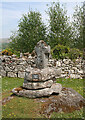
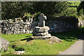
Information about this cup marked boulder, the Dunstone Cup Stone, comes from the Prehistoric Dartmoor Walks (PDW) website. Their notes tell us this is a "cup-marked stone at SX71677585, Dunstone. Dunstone Rock is a large, weathered undressed granite boulder aligned approximately due North-South. It is 2.4m long by 1.4m wide and 1.0m high. The surface has 13 cups which fall into two groups. Although some of the cups may be natural, Dunstone manor takes its name from this stone and is recorded in Domesday as "Dunestonetuna" suggesting a long tradition of importance attached to the stone. A tradition of paying rent money by placing money in the cups is recorded until recent times."
The PDW web page gives links to further information on Pastscape, Monument Number 898192 and also the Heritage Gateway for Devon & Dartmoor HER number MDV18864. They date this boulder to the Prehistoric (698000BC to 42AD) and note that the stone is on the green at Lower Dunstone. In 1989 they recorded in a gazetteer that this "is a boulder with ring decoration and no central cups, minimum age 1900-1600BC (uncalibrated radiocarbon years).
Note: Have you visited this site? Do you have any photographs, images or further information you can add?
You may be viewing yesterday's version of this page. To see the most up to date information please register for a free account.
Do not use the above information on other web sites or publications without permission of the contributor.
Nearby Images from Geograph Britain and Ireland:
©2019(licence)
©2009(licence)
©2020(licence)
©2020(licence)
©2014(licence)
The above images may not be of the site on this page, they are loaded from Geograph.
Please Submit an Image of this site or go out and take one for us!
Click here to see more info for this site
Nearby sites
Key: Red: member's photo, Blue: 3rd party photo, Yellow: other image, Green: no photo - please go there and take one, Grey: site destroyed
Download sites to:
KML (Google Earth)
GPX (GPS waypoints)
CSV (Garmin/Navman)
CSV (Excel)
To unlock full downloads you need to sign up as a Contributory Member. Otherwise downloads are limited to 50 sites.
Turn off the page maps and other distractions
Nearby sites listing. In the following links * = Image available
959m N 6° Saxon Well* Holy Well or Sacred Spring (SX718768)
1.5km E 91° Tunhill Rocks* Ancient Village or Settlement (SX7318975796)
1.8km E 100° Blackslade Down Cairn and Cist* Cist (SX7341275510)
1.8km ESE 110° Wittaburrow Cairn* Cairn (SX73347521)
1.9km ENE 72° Top Tor row Stone Row / Alignment (SX735764)
2.0km ENE 70° Top Tor Cairns* Cairn (SX7357476472)
2.1km E 88° Foales Arrishes* Ancient Village or Settlement (SX73777587)
2.5km E 80° Seven Lords' Lands* Stone Circle (SX74127623)
2.6km NNW 344° Hamel Down Cairn and Cist* Cairn (SX7100878345)
2.7km NNE 26° Chinkwell Tor Cairn* Cairn (SX7293078250)
3.0km E 94° Rippon Tor* Cairn (SX74667558)
3.2km NNW 343° Hamel Down Beacon cairn* Cairn (SX70837891)
3.2km SE 143° Buckland Ridge South Ring Cairn (SX73577324)
3.3km WSW 249° Corndon Down N Cairns* Barrow Cemetery (SX68587473)
3.3km SE 145° Ten Commandments Stone* Natural Stone / Erratic / Other Natural Feature (SX735731)
3.3km NNW 342° Blackaton Down south (Hamel Down)* Cairn (SX70737904)
3.4km NNW 342° Blackaton Down north (Hamel Down)* Cairn (SX70687909)
3.5km SSE 147° Stidwell* Holy Well or Sacred Spring (SX735729)
3.5km NNW 342° Two Barrows (Hamel Down)* Round Barrow(s) (SX70657921)
3.5km WSW 241° Corndon Down Cairns* Barrow Cemetery (SX68557420)
3.7km SW 223° Sherberton Common Multiple Stone Rows / Avenue (SX691732)
3.8km NE 38° Hound Tor Ring Cairn* Ring Cairn (SX7409778770)
3.8km NNW 342° Hamel Down* Barrow Cemetery (SX706795)
3.8km NNW 342° Single Barrow (Hamel Down)* Round Barrow(s) (SX70577953)
3.8km SW 229° Sherril Down Multiple Stone Rows / Avenue (SX687734)
View more nearby sites and additional images


 We would like to know more about this location. Please feel free to add a brief description and any relevant information in your own language.
 Wir möchten mehr über diese Stätte erfahren. Bitte zögern Sie nicht, eine kurze Beschreibung und relevante Informationen in Deutsch hinzuzufügen.
 Nous aimerions en savoir encore un peu sur les lieux. S'il vous plaît n'hesitez pas à ajouter une courte description et tous les renseignements pertinents dans votre propre langue.
 Quisieramos informarnos un poco más de las lugares. No dude en añadir una breve descripción y otros datos relevantes en su propio idioma.