


<< Our Photo Pages >> Branscombe's Loaf - Ring Cairn in England in Devon
Submitted by Anne T on Wednesday, 26 October 2016 Page Views: 1547
Neolithic and Bronze AgeSite Name: Branscombe's Loaf Alternative Name: BranscombeCountry: England County: Devon Type: Ring Cairn
Nearest Town: Okehampton Nearest Village: Sourton
Map Ref: SX55318912
Latitude: 50.683696N Longitude: 4.049499W
Condition:
| 5 | Perfect |
| 4 | Almost Perfect |
| 3 | Reasonable but with some damage |
| 2 | Ruined but still recognisable as an ancient site |
| 1 | Pretty much destroyed, possibly visible as crop marks |
| 0 | No data. |
| -1 | Completely destroyed |
| 5 | Superb |
| 4 | Good |
| 3 | Ordinary |
| 2 | Not Good |
| 1 | Awful |
| 0 | No data. |
| 5 | Can be driven to, probably with disabled access |
| 4 | Short walk on a footpath |
| 3 | Requiring a bit more of a walk |
| 2 | A long walk |
| 1 | In the middle of nowhere, a nightmare to find |
| 0 | No data. |
| 5 | co-ordinates taken by GPS or official recorded co-ordinates |
| 4 | co-ordinates scaled from a detailed map |
| 3 | co-ordinates scaled from a bad map |
| 2 | co-ordinates of the nearest village |
| 1 | co-ordinates of the nearest town |
| 0 | no data |
Be the first person to rate this site - see the 'Contribute!' box in the right hand menu.
Internal Links:
External Links:
I have visited· I would like to visit
lauraaurora visited on 7th Jul 2022 - their rating: Cond: 5 Amb: 5 Access: 2
")
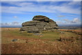
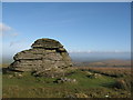
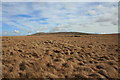
Information about Branscombe's Loaf Stone Ring Cairn Circle comes from the Prehistoric Dartmoor Walks (PDW) website. Their notes tell us this is one of four cairns on Corn Ridge.
The PDW web page gives links to further information on Pastscape, Monument Number 440498, which adds that this is a ring cairn measuring 16.5 metres in diameter and 0.3m high, 4.5 metres north west of a second tumulus.
The Heritage Gateway for Devon & Dartmoor HER number MDV48863 goes into more detail, describing this site as a "stone ring around a large rock. Diameter 18.5 m with bank 1.4 m wide and 0.3 m high. Situated at top of slope, dominating the approach to the moor from the north west." They date the ring cairn to the Bronze Age (2200BC to 701BC) and the enclosure to an "unknown date."
This ring cairn is also scheduled as Historic England List ID 1009797: Tor cairn surrounding Branscombe's Loaf forming part of a cemetery on Corn Ridge Summit.
You may be viewing yesterday's version of this page. To see the most up to date information please register for a free account.
Do not use the above information on other web sites or publications without permission of the contributor.
Nearby Images from Geograph Britain and Ireland:
©2010(licence)
©2011(licence)
©2013(licence)
©2010(licence)
©2010(licence)
The above images may not be of the site on this page, they are loaded from Geograph.
Please Submit an Image of this site or go out and take one for us!
Click here to see more info for this site
Nearby sites
Key: Red: member's photo, Blue: 3rd party photo, Yellow: other image, Green: no photo - please go there and take one, Grey: site destroyed
Download sites to:
KML (Google Earth)
GPX (GPS waypoints)
CSV (Garmin/Navman)
CSV (Excel)
To unlock full downloads you need to sign up as a Contributory Member. Otherwise downloads are limited to 50 sites.
Turn off the page maps and other distractions
Nearby sites listing. In the following links * = Image available
94m WNW 284° Corn Ridge Rock* Ring Cairn (SX5521989145)
135m W 268° Cornridge SE* Stone Circle (SX5517589119)
175m W 279° Corn Ridge Stone Ring Cairn Circle* Ring Cairn (SX5513889153)
773m WNW 293° Sourton Tors Cairn* Cairn (SX5460389438)
778m NW 305° Sourton Tors Stone Circle* Stone Circle (SX54688958)
927m WSW 252° Sourton Tors Ring Cairns* Ring Cairn (SX5441888858)
1.7km NNE 27° Homerton Hill North* Cist (SX56139065)
1.9km SSW 210° Little Links Tor* Stone Row / Alignment (SX5428587463)
2.2km SW 218° Great Nodden* Cist (SX5387487416)
2.2km WNW 300° Sourton Green Saxon Cross* Ancient Cross (SX534903)
2.3km NE 37° Longstone Hill* Standing Stone (Menhir) (SX56729089)
2.3km E 94° Fordsland Ledge Chambered cairn* Chambered Cairn (SX57588888)
2.4km NNE 33° Longstone Hill cairn* Cairn (SX56709113)
2.7km S 187° Great Links Tor Cairn* Cairn (SX5491686496)
2.7km E 86° High Willhays kerb cairn* Round Cairn (SX58038922)
2.7km E 82° High Willhays North Ring Cairn (SX58028944)
2.8km ENE 66° Yes Tor cairns* Barrow Cemetery (SX57959020)
3.2km NE 40° Black Down West Cairn (SX57469153)
4.1km W 270° Bridestowe Holy Well Holy Well or Sacred Spring (SX512892)
4.4km S 191° Doe Tor* Cist (SX54388485)
5.2km SSW 196° White Hill North East* Cairn (SX5371384190)
5.2km E 84° Oke Tor* Stone Row / Alignment (SX605895)
5.5km SSW 197° White Hill North Cairn Field Ring Cairn (SX53528395)
5.8km S 185° Ger Tor Cairn (SX54658338)
5.9km SSW 202° White Hill South* Ring Cairn (SX5294283680)
View more nearby sites and additional images


 We would like to know more about this location. Please feel free to add a brief description and any relevant information in your own language.
 Wir möchten mehr über diese Stätte erfahren. Bitte zögern Sie nicht, eine kurze Beschreibung und relevante Informationen in Deutsch hinzuzufügen.
 Nous aimerions en savoir encore un peu sur les lieux. S'il vous plaît n'hesitez pas à ajouter une courte description et tous les renseignements pertinents dans votre propre langue.
 Quisieramos informarnos un poco más de las lugares. No dude en añadir una breve descripción y otros datos relevantes en su propio idioma.