

<< Text Pages >> Dolmen de Soucho - Burial Chamber or Dolmen in France in Bretagne:Morbihan (56)
Submitted by holger_rix on Tuesday, 29 March 2016 Page Views: 913
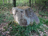
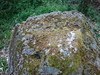
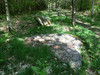
Neolithic and Bronze AgeSite Name: Dolmen de SouchoCountry: France Département: Bretagne:Morbihan (56) Type: Burial Chamber or Dolmen
Nearest Town: Pluvigner Nearest Village: Chanticoq
Latitude: 47.818747N Longitude: 2.943407W
Condition:
| 5 | Perfect |
| 4 | Almost Perfect |
| 3 | Reasonable but with some damage |
| 2 | Ruined but still recognisable as an ancient site |
| 1 | Pretty much destroyed, possibly visible as crop marks |
| 0 | No data. |
| -1 | Completely destroyed |
| 5 | Superb |
| 4 | Good |
| 3 | Ordinary |
| 2 | Not Good |
| 1 | Awful |
| 0 | No data. |
| 5 | Can be driven to, probably with disabled access |
| 4 | Short walk on a footpath |
| 3 | Requiring a bit more of a walk |
| 2 | A long walk |
| 1 | In the middle of nowhere, a nightmare to find |
| 0 | No data. |
| 5 | co-ordinates taken by GPS or official recorded co-ordinates |
| 4 | co-ordinates scaled from a detailed map |
| 3 | co-ordinates scaled from a bad map |
| 2 | co-ordinates of the nearest village |
| 1 | co-ordinates of the nearest town |
| 0 | no data |
Be the first person to rate this site - see the 'Contribute!' box in the right hand menu.
Internal Links:
External Links:
Burial Chamber (Dolmen) in Bretagne:Morbihan (56)
Chanticoq, Pluvigner, Lorient, Morbihan, Brittany
Source: T4T35.fr
You may be viewing yesterday's version of this page. To see the most up to date information please register for a free account.
Do not use the above information on other web sites or publications without permission of the contributor.
Nearby Images from Flickr
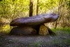
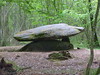
The above images may not be of the site on this page, but were taken nearby. They are loaded from Flickr so please click on them for image credits.
Click here to see more info for this site
Nearby sites
Click here to view sites on an interactive map of the areaKey: Red: member's photo, Blue: 3rd party photo, Yellow: other image, Green: no photo - please go there and take one, Grey: site destroyed
Download sites to:
KML (Google Earth)
GPX (GPS waypoints)
CSV (Garmin/Navman)
CSV (Excel)
To unlock full downloads you need to sign up as a Contributory Member. Otherwise downloads are limited to 50 sites.
Turn off the page maps and other distractions
Nearby sites listing. In the following links * = Image available
1.2km NW 310° Menhir dit la Croix Blanche (Morbihan) Standing Stone (Menhir)
2.1km NW 314° Kornevec Alignement* Stone Row / Alignment
2.3km N 354° Dolmen de Roh Du 1* Burial Chamber or Dolmen
2.4km WNW 298° L'Armoirie menhir* Standing Stone (Menhir)
2.4km NNW 342° Dolmen de Roh Du 3 Burial Chamber or Dolmen
2.5km N 358° Dolmen de Roh Du 2 Burial Chamber or Dolmen
2.9km WNW 284° Menhir de Kerpenru Standing Stone (Menhir)
3.4km WNW 297° Pen Ganquis menhir couché Standing Stone (Menhir)
3.6km NNW 329° Menhir de Kergludan* Standing Stone (Menhir)
4.1km E 85° Menhir de Kerigo Standing Stone (Menhir)
4.5km NW 321° Roh-Hir Standing Stone (Menhir)
4.5km WNW 298° Lann-er-Bein allée couverte* Passage Grave
4.6km E 79° Cosquéro Menhir* Standing Stone (Menhir)
4.9km WNW 301° Toul Er Rest Dolmen* Burial Chamber or Dolmen
5.6km WNW 292° L'Etoile allée couverte* Passage Grave
5.9km WNW 282° Allée Couverte de Men Braz Passage Grave
6.0km WNW 285° Men Braz menhir* Standing Stone (Menhir)
6.2km E 83° Men-Brasi-de-Kermar-Ker* Standing Stone (Menhir)
6.3km WNW 282° Men-Bihan Allée Couverte* Passage Grave
6.3km WNW 282° Menhir de Men Bihan* Standing Stone (Menhir)
6.3km WNW 287° Lambel Menhir* Standing Stone (Menhir)
6.4km E 84° Kermarquer menhir* Standing Stone (Menhir)
6.4km ENE 70° Pierres de Kerguéris* Natural Stone / Erratic / Other Natural Feature
6.5km E 86° Kerara Menhir* Standing Stone (Menhir)
6.8km ENE 71° Mégalithe-siège, Kerhero* Natural Stone / Erratic / Other Natural Feature
View more nearby sites and additional images


 We would like to know more about this location. Please feel free to add a brief description and any relevant information in your own language.
 Wir möchten mehr über diese Stätte erfahren. Bitte zögern Sie nicht, eine kurze Beschreibung und relevante Informationen in Deutsch hinzuzufügen.
 Nous aimerions en savoir encore un peu sur les lieux. S'il vous plaît n'hesitez pas à ajouter une courte description et tous les renseignements pertinents dans votre propre langue.
 Quisieramos informarnos un poco más de las lugares. No dude en añadir una breve descripción y otros datos relevantes en su propio idioma.