


<< Our Photo Pages >> Penfeidr Coedan - Ancient Mine, Quarry or other Industry in Wales in Pembrokeshire
Submitted by vicky on Monday, 30 September 2002 Page Views: 5439
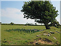
Multi-periodSite Name: Penfeidr Coedan Alternative Name: Stone RidgeCountry: Wales County: Pembrokeshire Type: Ancient Mine, Quarry or other Industry
Nearest Town: Newport Nearest Village: Brynberian
Map Ref: SN099369 Landranger Map Number: 145
Latitude: 51.997914N Longitude: 4.770557W
Condition:
| 5 | Perfect |
| 4 | Almost Perfect |
| 3 | Reasonable but with some damage |
| 2 | Ruined but still recognisable as an ancient site |
| 1 | Pretty much destroyed, possibly visible as crop marks |
| 0 | No data. |
| -1 | Completely destroyed |
| 5 | Superb |
| 4 | Good |
| 3 | Ordinary |
| 2 | Not Good |
| 1 | Awful |
| 0 | No data. |
| 5 | Can be driven to, probably with disabled access |
| 4 | Short walk on a footpath |
| 3 | Requiring a bit more of a walk |
| 2 | A long walk |
| 1 | In the middle of nowhere, a nightmare to find |
| 0 | No data. |
| 5 | co-ordinates taken by GPS or official recorded co-ordinates |
| 4 | co-ordinates scaled from a detailed map |
| 3 | co-ordinates scaled from a bad map |
| 2 | co-ordinates of the nearest village |
| 1 | co-ordinates of the nearest town |
| 0 | no data |
Internal Links:
External Links:
")
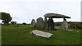
This site known as Penfeidr Coedan is thought to be the source of the stone that was used to make Pentre Ifan. It lies close to a standing stone of the same name and can be viewed from a field entrance at SN09853675 just up the road from Pentre Ifan.
You may be viewing yesterday's version of this page. To see the most up to date information please register for a free account.
")
")
Do not use the above information on other web sites or publications without permission of the contributor.
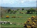
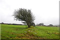
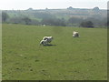
Nearby Images from Geograph Britain and Ireland:
©2009(licence)
©2015(licence)
©2017(licence)
©2017(licence)
©2013(licence)
The above images may not be of the site on this page, they are loaded from Geograph.
Please Submit an Image of this site or go out and take one for us!
Click here to see more info for this site
Nearby sites
Key: Red: member's photo, Blue: 3rd party photo, Yellow: other image, Green: no photo - please go there and take one, Grey: site destroyed
Download sites to:
KML (Google Earth)
GPX (GPS waypoints)
CSV (Garmin/Navman)
CSV (Excel)
To unlock full downloads you need to sign up as a Contributory Member. Otherwise downloads are limited to 50 sites.
![]()
Turn off the page maps and other distractions
Nearby sites listing. In the following links * = Image available
nankm 0° Penfeidr Coedan Stone* Standing Stone (Menhir) (SN099369)
126m NNE 16° Pentre Ifan* Portal Tomb (SN09943702)
822m WSW 254° Tycanol Hillfort (SN091367)
920m SW 227° Carnedd Meibion Owen Tor 3* Natural Stone / Erratic / Other Natural Feature (SN092363)
1.4km SSW 209° St Brynach's Well Holy Well or Sacred Spring (SN09173568)
1.4km SW 215° Penlan Stone Pair* Standing Stones (SN09033575)
1.6km ENE 61° Castell Llwyd Ancient Village or Settlement (SN113376)
1.6km SW 222° Troed y rhiw Stone Row / Alignment (SN0879235756)
1.7km SSW 208° The Penlan Stone* Standing Stone (Menhir) (SN09053545)
1.9km ESE 111° Craig Rhosyfelin* Rock Outcrop (SN11653614)
2.0km ENE 76° Penybenglog fort Hillfort (SN119373)
2.1km ENE 64° Castell Mawr (Pembrokeshire)* Hillfort (SN11873776)
2.2km SE 142° Brynberian Round Barrow(s) (SN112351)
2.5km SSE 157° Bedd yr Afanc* Passage Grave (SN10793458)
2.6km WNW 292° Brithdir Mawr Barrow* Modern Stone Circle etc (SN0753137967)
2.6km NE 43° St Dogfaels Well Holy Well or Sacred Spring (SN11773874)
2.8km NE 38° Castell Henllys* Promontory Fort / Cliff Castle (SN11723905)
2.8km N 8° Cwm Gloyne Hillfort (SN104397)
3.0km WNW 288° Brithdir Mawr stone circle* Modern Stone Circle etc (SN071379)
3.0km NE 42° Penpedwast Ancient Village or Settlement (SN12013903)
3.2km SSW 206° Waun Mawn NE* Standing Stones (SN08353405)
3.3km WSW 243° Trefach Enclosure Hillfort (SN06923555)
3.4km N 4° Trefael* Rock Art (SN10294028)
3.5km NNW 331° Nevern Churchyard* Standing Stone (Menhir) (SN0833340028)
3.5km SSW 210° Waun Mawn W* Standing Stone (Menhir) (SN08033394)
View more nearby sites and additional images


 We would like to know more about this location. Please feel free to add a brief description and any relevant information in your own language.
 Wir möchten mehr über diese Stätte erfahren. Bitte zögern Sie nicht, eine kurze Beschreibung und relevante Informationen in Deutsch hinzuzufügen.
 Nous aimerions en savoir encore un peu sur les lieux. S'il vous plaît n'hesitez pas à ajouter une courte description et tous les renseignements pertinents dans votre propre langue.
 Quisieramos informarnos un poco más de las lugares. No dude en añadir una breve descripción y otros datos relevantes en su propio idioma.