


<< Our Photo Pages >> Dolmen de la Pierre-Plate - Burial Chamber or Dolmen in France in Bourgogne:Nièvre (58)
Submitted by holger_rix on Wednesday, 16 March 2016 Page Views: 1273
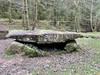
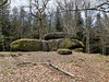
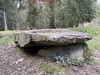
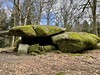
Neolithic and Bronze AgeSite Name: Dolmen de la Pierre-PlateCountry: France Département: Bourgogne:Nièvre (58) Type: Burial Chamber or Dolmen
Nearest Town: Clamecy Nearest Village: Dun-les-Places
Latitude: 47.281479N Longitude: 4.053249E
Condition:
| 5 | Perfect |
| 4 | Almost Perfect |
| 3 | Reasonable but with some damage |
| 2 | Ruined but still recognisable as an ancient site |
| 1 | Pretty much destroyed, possibly visible as crop marks |
| 0 | No data. |
| -1 | Completely destroyed |
| 5 | Superb |
| 4 | Good |
| 3 | Ordinary |
| 2 | Not Good |
| 1 | Awful |
| 0 | No data. |
| 5 | Can be driven to, probably with disabled access |
| 4 | Short walk on a footpath |
| 3 | Requiring a bit more of a walk |
| 2 | A long walk |
| 1 | In the middle of nowhere, a nightmare to find |
| 0 | No data. |
| 5 | co-ordinates taken by GPS or official recorded co-ordinates |
| 4 | co-ordinates scaled from a detailed map |
| 3 | co-ordinates scaled from a bad map |
| 2 | co-ordinates of the nearest village |
| 1 | co-ordinates of the nearest town |
| 0 | no data |
Be the first person to rate this site - see the 'Contribute!' box in the right hand menu.
Internal Links:
External Links:
")
Dun-les-Places, Clamecy, Nièvre, Bourgogne-Franche-Comté
Source: T4T35.fr
You may be viewing yesterday's version of this page. To see the most up to date information please register for a free account.
")
")
Do not use the above information on other web sites or publications without permission of the contributor.
Nearby Images from Flickr
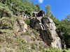
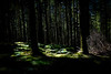
The above images may not be of the site on this page, but were taken nearby. They are loaded from Flickr so please click on them for image credits.
Click here to see more info for this site
Nearby sites
Click here to view sites on an interactive map of the areaKey: Red: member's photo, Blue: 3rd party photo, Yellow: other image, Green: no photo - please go there and take one, Grey: site destroyed
Download sites to:
KML (Google Earth)
GPX (GPS waypoints)
CSV (Garmin/Navman)
CSV (Excel)
To unlock full downloads you need to sign up as a Contributory Member. Otherwise downloads are limited to 50 sites.
Turn off the page maps and other distractions
Nearby sites listing. In the following links * = Image available
998m SE 146° Chevresse Dolmen* Burial Chamber or Dolmen
7.5km SSW 196° Table du Festin des Fées Rock Art
9.5km NNW 330° Roche aux Fées (Quarré-les-Tombes)* Rock Outcrop
12.5km NE 43° Poron Meurger* Rock Art
16.2km NE 41° Pierre Pelot* Standing Stone (Menhir)
16.2km NE 41° Roche d'Arthur* Standing Stone (Menhir)
18.7km SSW 198° Pierres à Sacrifices de Faubouloin Rock Outcrop
21.9km ESE 105° Pierre-Pointe* Standing Stone (Menhir)
22.7km NE 46° Cimetière Menhir* Standing Stone (Menhir)
26.2km NW 324° En-Pierrotte Burial Chamber or Dolmen
28.2km SSW 211° La Pierre de Montbracon Standing Stone (Menhir)
29.2km E 98° Dolmen du Champ-du-Saule 2 Burial Chamber or Dolmen
29.2km E 98° Dolmen du Champ-du-Saule 1 Burial Chamber or Dolmen
29.3km E 98° Dolmen du Champ-du-Saule 3 Burial Chamber or Dolmen
33.3km NNE 30° Menhir-Sainte-Christine* Standing Stone (Menhir)
36.1km WNW 285° Tannay Menhir Standing Stone (Menhir)
36.5km N 358° Menhir du Bois des Haies Standing Stone (Menhir)
36.8km ENE 71° Camp de Myard* Ancient Village or Settlement
38.1km NNW 326° Camp Antique de Cora-Villaucerre Ancient Village or Settlement
38.1km SSE 148° Camp de la Justice Alignements* Stone Row / Alignment
38.2km N 3° Menhir de la Femme Blanche Standing Stone (Menhir)
38.4km NW 325° Menhir dit la Grosse-Borne Standing Stone (Menhir)
39.7km S 182° Oppidum de Bibracte* Hillfort
39.9km N 351° Tumulus de Tormancy Round Barrow(s)
40.2km SSE 154° Temple of Janus (Autun)* Ancient Temple
View more nearby sites and additional images


 We would like to know more about this location. Please feel free to add a brief description and any relevant information in your own language.
 Wir möchten mehr über diese Stätte erfahren. Bitte zögern Sie nicht, eine kurze Beschreibung und relevante Informationen in Deutsch hinzuzufügen.
 Nous aimerions en savoir encore un peu sur les lieux. S'il vous plaît n'hesitez pas à ajouter une courte description et tous les renseignements pertinents dans votre propre langue.
 Quisieramos informarnos un poco más de las lugares. No dude en añadir una breve descripción y otros datos relevantes en su propio idioma.