


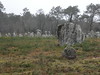
<< Our Photo Pages >> Allée Couverte de Kerlagad - Passage Grave in France in Bretagne:Morbihan (56)
Submitted by holger_rix on Tuesday, 12 January 2016 Page Views: 1492
Neolithic and Bronze AgeSite Name: Allée Couverte de KerlagadCountry: France Département: Bretagne:Morbihan (56) Type: Passage Grave
Nearest Town: Ploemel Nearest Village: Keroulin
Latitude: 47.618960N Longitude: 3.04341W
Condition:
| 5 | Perfect |
| 4 | Almost Perfect |
| 3 | Reasonable but with some damage |
| 2 | Ruined but still recognisable as an ancient site |
| 1 | Pretty much destroyed, possibly visible as crop marks |
| 0 | No data. |
| -1 | Completely destroyed |
| 5 | Superb |
| 4 | Good |
| 3 | Ordinary |
| 2 | Not Good |
| 1 | Awful |
| 0 | No data. |
| 5 | Can be driven to, probably with disabled access |
| 4 | Short walk on a footpath |
| 3 | Requiring a bit more of a walk |
| 2 | A long walk |
| 1 | In the middle of nowhere, a nightmare to find |
| 0 | No data. |
| 5 | co-ordinates taken by GPS or official recorded co-ordinates |
| 4 | co-ordinates scaled from a detailed map |
| 3 | co-ordinates scaled from a bad map |
| 2 | co-ordinates of the nearest village |
| 1 | co-ordinates of the nearest town |
| 0 | no data |
Be the first person to rate this site - see the 'Contribute!' box in the right hand menu.
Internal Links:
External Links:
")
Keroulin, Ploemel, Lorient, Morbihan, Brittany
Source: T4T35.fr
You may be viewing yesterday's version of this page. To see the most up to date information please register for a free account.
")
Do not use the above information on other web sites or publications without permission of the contributor.
Nearby Images from Flickr
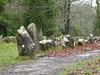
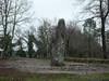
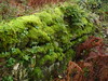
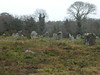
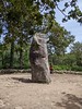
The above images may not be of the site on this page, but were taken nearby. They are loaded from Flickr so please click on them for image credits.
Click here to see more info for this site
Nearby sites
Click here to view sites on an interactive map of the areaKey: Red: member's photo, Blue: 3rd party photo, Yellow: other image, Green: no photo - please go there and take one, Grey: site destroyed
Download sites to:
KML (Google Earth)
GPX (GPS waypoints)
CSV (Garmin/Navman)
CSV (Excel)
To unlock full downloads you need to sign up as a Contributory Member. Otherwise downloads are limited to 50 sites.
Turn off the page maps and other distractions
Nearby sites listing. In the following links * = Image available
225m ESE 108° Menhir de Kerlagad (Carnac)* Standing Stone (Menhir)
424m WNW 297° Dolmen de La Madeleine (Carnac)* Burial Chamber or Dolmen
472m SSE 161° Dolmen de Mané-Roch 1* Burial Chamber or Dolmen
477m SSE 162° Dolmen de Mané-Roch 2* Burial Chamber or Dolmen
534m ESE 104° Menhir de Kerhouant Standing Stone (Menhir)
584m S 176° Mané-Roc'h 1* Standing Stone (Menhir)
623m WSW 256° Menhir dit Er-Roh 3* Standing Stone (Menhir)
654m WSW 255° Menhir dit Er-Roh 2* Standing Stone (Menhir)
654m WSW 254° Dolmen du Clos Pernel* Burial Chamber or Dolmen
657m WSW 252° Dolmen dit Er-Roh* Burial Chamber or Dolmen
660m WSW 250° Menhirs dits Er-Roh* Standing Stones
700m W 276° Dolmen de Er-Roc'h-Feutet* Burial Chamber or Dolmen
836m NE 49° Le Lizo Dolmen Burial Chamber or Dolmen
837m NNW 334° Menhir de Gouyanzeur* Standing Stone (Menhir)
955m NNE 32° Dolmen de la Colline du Lizo Burial Chamber or Dolmen
1.1km ENE 58° Dolmen de Mané Er Mour Burial Chamber or Dolmen
1.2km E 92° Dolmen de Kerourang 3* Burial Chamber or Dolmen
1.3km SW 221° Moustoir Champ de Menhirs* Standing Stones
1.3km SSW 193° Menhir de Kerlescan 1* Standing Stone (Menhir)
1.3km SSW 211° Menhirs de Parc er Manio Stone Row / Alignment
1.3km E 98° Dolmen dit Mane Roc'h en Ezel* Passage Grave
1.3km SSW 196° Menhir de Kerlescan 2 Standing Stone (Menhir)
1.5km WSW 240° Menhir du tumulus du Moustoir* Standing Stone (Menhir)
1.5km SSW 193° Kerlescan nord allée couverte* Passage Grave
1.5km WSW 247° Moustoir-Rohec menhir* Standing Stone (Menhir)
View more nearby sites and additional images


 We would like to know more about this location. Please feel free to add a brief description and any relevant information in your own language.
 Wir möchten mehr über diese Stätte erfahren. Bitte zögern Sie nicht, eine kurze Beschreibung und relevante Informationen in Deutsch hinzuzufügen.
 Nous aimerions en savoir encore un peu sur les lieux. S'il vous plaît n'hesitez pas à ajouter une courte description et tous les renseignements pertinents dans votre propre langue.
 Quisieramos informarnos un poco más de las lugares. No dude en añadir una breve descripción y otros datos relevantes en su propio idioma.