

<< Our Photo Pages >> Broch of Burland - Broch or Nuraghe in Scotland in Shetland
Submitted by h_fenton on Saturday, 24 January 2015 Page Views: 5859
Iron Age and Later PrehistorySite Name: Broch of BurlandCountry: Scotland County: Shetland Type: Broch or Nuraghe
Nearest Town: Lerwick
Map Ref: HU44553607
Latitude: 60.106808N Longitude: 1.200522W
Condition:
| 5 | Perfect |
| 4 | Almost Perfect |
| 3 | Reasonable but with some damage |
| 2 | Ruined but still recognisable as an ancient site |
| 1 | Pretty much destroyed, possibly visible as crop marks |
| 0 | No data. |
| -1 | Completely destroyed |
| 5 | Superb |
| 4 | Good |
| 3 | Ordinary |
| 2 | Not Good |
| 1 | Awful |
| 0 | No data. |
| 5 | Can be driven to, probably with disabled access |
| 4 | Short walk on a footpath |
| 3 | Requiring a bit more of a walk |
| 2 | A long walk |
| 1 | In the middle of nowhere, a nightmare to find |
| 0 | No data. |
| 5 | co-ordinates taken by GPS or official recorded co-ordinates |
| 4 | co-ordinates scaled from a detailed map |
| 3 | co-ordinates scaled from a bad map |
| 2 | co-ordinates of the nearest village |
| 1 | co-ordinates of the nearest town |
| 0 | no data |
Internal Links:
External Links:
I have visited· I would like to visit
Mazlow would like to visit
SolarMegalith visited on 14th Jun 2015 - their rating: Cond: 3 Amb: 5 Access: 3
")
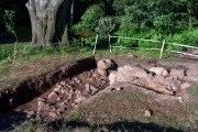
Viewed from the landward side the site seems a little unimpressive, a series of banks and a grassy mound, but on the south side the outer wall of the broch survives to a height of about three metres. The interior of the broch at first site appears small but this is a secondary structure hollowed out within the collapse of the broch. The entrance to the broch stands very close to the edge of the cliff.
The entrance passageway is in a state of partial collapse and is mostly choked with debris. The entrance to a guard cell to the right of the passage is no longer accessible, although the roof of the cell has collapsed (or been deliberately broken into) revealing a cavity 2.2metres deep to the top of the collapsed material in the cell. Traces of an intra-mural gallery can be seen in the circuit of the broch wall.
Canmore site 998
You may be viewing yesterday's version of this page. To see the most up to date information please register for a free account.
")
")
")
")
")
")
")
")
")
")
")
")
")
")
")
")
")
")
")
Do not use the above information on other web sites or publications without permission of the contributor.
Click here to see more info for this site
Nearby sites
Key: Red: member's photo, Blue: 3rd party photo, Yellow: other image, Green: no photo - please go there and take one, Grey: site destroyed
Download sites to:
KML (Google Earth)
GPX (GPS waypoints)
CSV (Garmin/Navman)
CSV (Excel)
To unlock full downloads you need to sign up as a Contributory Member. Otherwise downloads are limited to 50 sites.
Turn off the page maps and other distractions
Nearby sites listing. In the following links * = Image available
1.6km NW 307° Loch of Brindister* Stone Fort or Dun (HU43263701)
5.1km NNE 22° Clickhimin* Broch or Nuraghe (HU46434081)
5.9km NNE 29° Shetland Museum* Museum (HU474413)
6.7km S 185° Clodie Knowe* Broch or Nuraghe (HU441294)
6.8km NNW 332° Tingwall stone* Standing Stone (Menhir) (HU4123742029)
6.8km WSW 258° Gulver Knowe burnt mound* Artificial Mound (HU37893455)
6.9km SSW 194° Everglades North Broch or Nuraghe (HU43002930)
7.2km NNE 31° Burnt Mound of Cruester* Ancient Village or Settlement (HU4816142310)
7.3km NW 320° Loch of Houlland Ancient Village or Settlement (HU39754161)
7.5km WSW 245° East Burra, Yaa Field Standing Stone (Menhir) (HU3780532835)
7.8km ENE 65° Wadbister Souterrain* Souterrain (Fogou, Earth House) (HU5163139487)
8.1km NE 34° Stane o'Cruester* Standing Stone (Menhir) (HU490428)
8.3km WSW 246° West Burra, Mid Field Standing Stone (Menhir) (HU3700932591)
8.3km WSW 246° West Burra, Mid Field* Standing Stone (Menhir) (HU37003259)
8.4km S 190° Broch of Mail* Broch or Nuraghe (HU43252779)
9.0km WSW 240° Papil Pictish Stone Cross Slab* Class III Pictish Cross Slab (HU368315)
9.6km ENE 60° Noss Sound Broch* Broch or Nuraghe (HU528410)
9.8km NE 51° Bressay Pictish Cross Slab* Class III Pictish Cross Slab (HU5210042300)
9.8km NE 51° Cullingsburgh* Broch or Nuraghe (HU521423)
10.6km NNW 328° Easthouse* Standing Stones (HU388450)
10.8km NNW 340° Westings Hill* Stone Circle (HU4068346194)
11.1km NNW 340° Wormadale Hill* Standing Stone (Menhir) (HU4053046490)
12.4km S 174° Mousa Burnt Mounds* Artificial Mound (HU45942370)
12.5km S 175° Mousa Broch* Broch or Nuraghe (HU457236)
12.9km S 180° Burraland* Broch or Nuraghe (HU44682319)
View more nearby sites and additional images


 We would like to know more about this location. Please feel free to add a brief description and any relevant information in your own language.
 Wir möchten mehr über diese Stätte erfahren. Bitte zögern Sie nicht, eine kurze Beschreibung und relevante Informationen in Deutsch hinzuzufügen.
 Nous aimerions en savoir encore un peu sur les lieux. S'il vous plaît n'hesitez pas à ajouter une courte description et tous les renseignements pertinents dans votre propre langue.
 Quisieramos informarnos un poco más de las lugares. No dude en añadir una breve descripción y otros datos relevantes en su propio idioma.