 with our Megalithic Portal iPhone app")


<< Text Pages >> Big Circle J2 - Misc. Earthwork in Jordan
Submitted by davidmorgan on Thursday, 06 November 2014 Page Views: 2105
Multi-periodSite Name: Big Circle J2Country: Jordan Type: Misc. Earthwork
Latitude: 30.865726N Longitude: 35.935441E
Condition:
| 5 | Perfect |
| 4 | Almost Perfect |
| 3 | Reasonable but with some damage |
| 2 | Ruined but still recognisable as an ancient site |
| 1 | Pretty much destroyed, possibly visible as crop marks |
| 0 | No data. |
| -1 | Completely destroyed |
| 5 | Superb |
| 4 | Good |
| 3 | Ordinary |
| 2 | Not Good |
| 1 | Awful |
| 0 | No data. |
| 5 | Can be driven to, probably with disabled access |
| 4 | Short walk on a footpath |
| 3 | Requiring a bit more of a walk |
| 2 | A long walk |
| 1 | In the middle of nowhere, a nightmare to find |
| 0 | No data. |
| 5 | co-ordinates taken by GPS or official recorded co-ordinates |
| 4 | co-ordinates scaled from a detailed map |
| 3 | co-ordinates scaled from a bad map |
| 2 | co-ordinates of the nearest village |
| 1 | co-ordinates of the nearest town |
| 0 | no data |
Internal Links:
External Links:
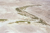
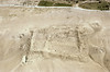
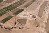
Misc. Earthwork in Jordan
A strange circle of stones.
You may be viewing yesterday's version of this page. To see the most up to date information please register for a free account.
Do not use the above information on other web sites or publications without permission of the contributor.
Nearby Images from Flickr
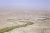

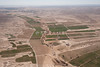
The above images may not be of the site on this page, but were taken nearby. They are loaded from Flickr so please click on them for image credits.
Click here to see more info for this site
Nearby sites
Click here to view sites on an interactive map of the areaKey: Red: member's photo, Blue: 3rd party photo, Yellow: other image, Green: no photo - please go there and take one, Grey: site destroyed
Download sites to:
KML (Google Earth)
GPX (GPS waypoints)
CSV (Garmin/Navman)
CSV (Excel)
To unlock full downloads you need to sign up as a Contributory Member. Otherwise downloads are limited to 50 sites.
Turn off the page maps and other distractions
Nearby sites listing. In the following links * = Image available
5.9km NNE 13° Big Circle J1 Misc. Earthwork
22.1km NW 313° Dhat Ras* Ancient Temple
22.7km WNW 282° Khirbat Al-Dharieh* Ancient Temple
24.7km WNW 298° Khirbet Al-Tannur* Ancient Temple
25.7km SSW 202° Big Circle J4 Misc. Earthwork
34.3km WSW 247° Botzrah* Ancient Village or Settlement
35.6km WSW 255° Sel'a* Hillfort
36.1km SW 220° Khirbat Dabur* Ancient Village or Settlement
36.1km SW 228° Big Circle J3 Misc. Earthwork
38.8km SW 214° Jabal Al-Aswad* Hillfort
40.8km NNW 337° Ader.* Standing Stone (Menhir)
41.5km NNW 328° Al Karak castle * Hillfort
44.3km SW 219° East of Dana Nature Reserve* Ancient Village or Settlement
45.0km NNW 338° Khirbat Iskandar* Ancient Village or Settlement
48.8km NNW 337° Qasr Ar-Rabba* Ancient Temple
50.0km WSW 238° Wadi Feinan* Ancient Mine, Quarry or other Industry
51.6km SW 224° Shobak Castle* Hillfort
51.9km WSW 247° Khirbat en-Nahas* Ancient Mine, Quarry or other Industry
52.0km NNW 341° Wadi Walla Roman mile stone* Marker Stone
53.7km SW 223° Al-Shobak Dolmen* Burial Chamber or Dolmen
55.8km NW 321° Zahrat adh-Dhra’ 2 Ancient Village or Settlement
57.7km NW 318° Bab edh-Dhra Ancient Village or Settlement
57.7km SW 233° Small Wadi Malaqa Petroglyph* Carving
58.3km SW 232° Wadi Malaqa Petroglyphs* Carving
60.8km NNW 341° Redjom el A'abed* Ancient Village or Settlement
View more nearby sites and additional images


 We would like to know more about this location. Please feel free to add a brief description and any relevant information in your own language.
 Wir möchten mehr über diese Stätte erfahren. Bitte zögern Sie nicht, eine kurze Beschreibung und relevante Informationen in Deutsch hinzuzufügen.
 Nous aimerions en savoir encore un peu sur les lieux. S'il vous plaît n'hesitez pas à ajouter une courte description et tous les renseignements pertinents dans votre propre langue.
 Quisieramos informarnos un poco más de las lugares. No dude en añadir una breve descripción y otros datos relevantes en su propio idioma.