


<< Our Photo Pages >> Burness - Broch or Nuraghe in Scotland in Orkney
Submitted by howar on Monday, 16 June 2014 Page Views: 2704
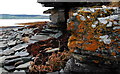
Iron Age and Later PrehistorySite Name: Burness Alternative Name: Chapel Knowe, Chapel Point, Chapel ParkCountry: Scotland County: Orkney Type: Broch or Nuraghe
Nearest Town: Finstown
Map Ref: HY38821557
Latitude: 59.022783N Longitude: 3.067322W
Condition:
| 5 | Perfect |
| 4 | Almost Perfect |
| 3 | Reasonable but with some damage |
| 2 | Ruined but still recognisable as an ancient site |
| 1 | Pretty much destroyed, possibly visible as crop marks |
| 0 | No data. |
| -1 | Completely destroyed |
| 5 | Superb |
| 4 | Good |
| 3 | Ordinary |
| 2 | Not Good |
| 1 | Awful |
| 0 | No data. |
| 5 | Can be driven to, probably with disabled access |
| 4 | Short walk on a footpath |
| 3 | Requiring a bit more of a walk |
| 2 | A long walk |
| 1 | In the middle of nowhere, a nightmare to find |
| 0 | No data. |
| 5 | co-ordinates taken by GPS or official recorded co-ordinates |
| 4 | co-ordinates scaled from a detailed map |
| 3 | co-ordinates scaled from a bad map |
| 2 | co-ordinates of the nearest village |
| 1 | co-ordinates of the nearest town |
| 0 | no data |
Internal Links:
External Links:
")
RCAHMS record no HY31NE 1 at Chapel Point, south of Burness in Firth, goes by the name of Chapel Knowe but may have been given this name in modern times. There is no specific tradition of a chapel, however the same is true of Kirkbreck in Holm. Somewhere there was a Chapel Park [park=quoy 'enclosure], and the archaeologists relate this to a twenty metre stone spread running NW from the mound, but I don't go for an unchanged mound abutting a chapel (at least Kirkbreck has two big long mounds connected by a neck). In 1922 Mr Stevenson, the landowner, removed copious amounts of stone to build very sturdy fieldwalls, despite which the broch profile is still obvious.
A draper called Turfus found in the debris an incised 40" fragment of red sandstone with a two-and-a-half inch high cloaked figure and other assorted markings. On the west side a broch wall section 14' long and 9' high was exposed, having a 2' thick secondary wall built against the face. At its south end a lintelled passage led to a corbelled mural cell with a void above that. The mound sits on a platform aligned N/S and up to 25m across according to which direction you look. Hugh Marwick, who followed up on the discovery, estimated the broch interior as only twenty feet.
For my first look-see I only got as far as East Qatquoy - it was near the end of a long walk (with Burness farm some way off still), there appeared to be kie in the field and I wasn't certain of the tides even if I could find a way to the shore. At high zoom I see a low scoop coming from the mound. I presume this is the assumed chapel enclosure, but it brings to my mind the stony areas landward of two of the Evie brochs. Though someone has walked from the Skerries of Coubister to Damsay I see no reason the objective couldn't have been getting from Damsay to Burness. This site had a pre-eminent view, from Finstown through Kirkwall all the way around to Crookness, taking in all the islands in that view.
You may be viewing yesterday's version of this page. To see the most up to date information please register for a free account.
")
")
Do not use the above information on other web sites or publications without permission of the contributor.
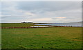
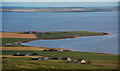
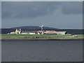
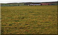
Nearby Images from Geograph Britain and Ireland:
©2008(licence)
©2010(licence)
©2013(licence)
©2010(licence)
©2010(licence)
The above images may not be of the site on this page, they are loaded from Geograph.
Please Submit an Image of this site or go out and take one for us!
Click here to see more info for this site
Nearby sites
Key: Red: member's photo, Blue: 3rd party photo, Yellow: other image, Green: no photo - please go there and take one, Grey: site destroyed
Download sites to:
KML (Google Earth)
GPX (GPS waypoints)
CSV (Garmin/Navman)
CSV (Excel)
To unlock full downloads you need to sign up as a Contributory Member. Otherwise downloads are limited to 50 sites.
Turn off the page maps and other distractions
Nearby sites listing. In the following links * = Image available
1.8km S 179° Site C Circular Feature from the Rising Tide project Standing Stones (HY3882313776)
1.9km NNW 326° Broch of Redland* Broch or Nuraghe (HY37801715)
2.1km WSW 250° Benziaroth* Artificial Mound (HY36781488)
2.5km N 4° Oyce of Isbister* Round Barrow(s) (HY39021802)
2.6km NW 305° Redland settlement Ancient Village or Settlement (HY367171)
2.8km S 175° Ingshowe* Broch or Nuraghe (HY390128)
3.0km WSW 242° The Hillock* Broch or Nuraghe (HY361142)
3.1km SSE 162° Rennibister Souterrain* Souterrain (Fogou, Earth House) (HY39731260)
3.3km NNE 19° St Mary's Kirk, Isbister* Broch or Nuraghe (HY39971872)
3.7km SW 220° Cuween Hill* Chambered Cairn (HY36421277)
3.7km WSW 244° Rowamo Cottage* Artificial Mound (HY35451400)
3.8km S 175° Nabban* Holy Well or Sacred Spring (HY391118)
3.9km SE 132° Quanterness* Chambered Cairn (HY417129)
4.0km ESE 115° Ramberry Cairn Chambered Cairn (HY42401383)
4.0km NNE 15° Sandyhall* Barrow Cemetery (HY399194)
4.0km SSE 148° Wideford Hill* Chambered Cairn (HY40901211)
4.2km NW 316° The Lyde Stones* Standing Stone (Menhir) (HY3596718643)
4.4km WSW 252° Howe Harper* Chambered Cairn (HY346143)
4.6km WSW 258° Wasdale (Orkney)* Crannog (HY343147)
4.6km SE 144° Heathfield Chambered Cairn (HY415118)
4.6km SE 138° Wideford Hill Cairn* Cairn (HY419121)
4.7km NNW 336° Black Knowe of Blubbersdale* Round Barrow(s) (HY36951988)
4.8km WSW 243° Hill of Heddle* Round Barrow(s) (HY345135)
4.8km SSE 159° Smerquoy ancient settlement* Ancient Village or Settlement (HY40501109)
5.1km WNW 291° Knowes of Trotty* Barrow Cemetery (HY341175)
View more nearby sites and additional images


 We would like to know more about this location. Please feel free to add a brief description and any relevant information in your own language.
 Wir möchten mehr über diese Stätte erfahren. Bitte zögern Sie nicht, eine kurze Beschreibung und relevante Informationen in Deutsch hinzuzufügen.
 Nous aimerions en savoir encore un peu sur les lieux. S'il vous plaît n'hesitez pas à ajouter une courte description et tous les renseignements pertinents dans votre propre langue.
 Quisieramos informarnos un poco más de las lugares. No dude en añadir una breve descripción y otros datos relevantes en su propio idioma.