


<< Our Photo Pages >> Aneyoshi tsunami warning stone tablet - Modern Stone Circle etc in Japan in Honshū
Submitted by Aska on Saturday, 22 June 2013 Page Views: 10504
Modern SitesSite Name: Aneyoshi tsunami warning stone tablet Alternative Name: 姉吉Country: Japan Region: Honshū Type: Modern Stone Circle etc
Nearest Town: Miyako (Iwate pref.) Nearest Village: Omoe 重茂
Latitude: 39.534220N Longitude: 142.045170E
Condition:
| 5 | Perfect |
| 4 | Almost Perfect |
| 3 | Reasonable but with some damage |
| 2 | Ruined but still recognisable as an ancient site |
| 1 | Pretty much destroyed, possibly visible as crop marks |
| 0 | No data. |
| -1 | Completely destroyed |
| 5 | Superb |
| 4 | Good |
| 3 | Ordinary |
| 2 | Not Good |
| 1 | Awful |
| 0 | No data. |
| 5 | Can be driven to, probably with disabled access |
| 4 | Short walk on a footpath |
| 3 | Requiring a bit more of a walk |
| 2 | A long walk |
| 1 | In the middle of nowhere, a nightmare to find |
| 0 | No data. |
| 5 | co-ordinates taken by GPS or official recorded co-ordinates |
| 4 | co-ordinates scaled from a detailed map |
| 3 | co-ordinates scaled from a bad map |
| 2 | co-ordinates of the nearest village |
| 1 | co-ordinates of the nearest town |
| 0 | no data |
Internal Links:
External Links:
")
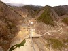
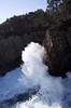
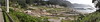
The tsunami on 11 March 2011 went upstream 500m from the seashore, destroyed the fishing port and the camping site on the Aneyoshi bay, reached up to 150m point (39.53338N,142.04460E,40m alt) to this tablet (55m alt), now another stone post standing at the reaching point. All the people in Aneyoshi hamlet who followed the order on the tablet survived the catastrophe.
The sentence on the tablet is as follows :
The homes on higher places will guarantee the comforts of the descendants,
Remind the horror of the tsunamis, do not build homes below this point.
We suffered tsunamis in 1896 and also in 1933, only 2 villagers in the former disaster and 4 in the latter survived.
Keep on your guard even years pass by.
317 stone tablets were built after the 2 tsunamis, 125 (40%) of them were washed away or destroyed by the 2011 tsunami. The sentences on the tablets, except the requiem poetry, the lists of the victims and the detailed records of the disaster (sometimes written in Chinese, which was regarded as the formal form like Latin in the western culture), are classified into 5 patterns:
A. (9 examples including variations)
Earthquake, Sea roaring, then Tsunami.
B. (19 examples including variations and abridged versions)
Tsunami will follow the earthquake.
Gather here (or, Rush away to higher places) after the earthquake (or, after the sudden ebb).
When tsunami comes, rush to anywhere as high as here.
Never try to run further, tsunami will catch up soon.
Keep the nearest higher points in mind.
Do not build houses on lower places than the designated area by the authorities.
C. (68 examples including variations)
Earthquake is the omen of the subsequent tsunami.
Watch out for it at least 1 hour.
When it comes, rush away to higher places.
Never reside on the submerged areas again.
D. (4 examples including variations)
Always watch out for a sudden tsunami.
Evolve a tsunami when the sea roars after the earthquake.
Ring the warning bells when the tide ebbed.
Rush away when the tsunami comes.
Never mind about money and goods, only try to survive.
The 5th sentence on the Aneyoshi tablet is one and only, excellent one.
It is better to take the southbound road from Miyako city center to Aneyoshi hamlet, the northbound road from Yamada town (山田町) is so narrow and too much winding to let the car from other direction go past.
The map and inventory of tsunami stone tablets.
Legend of the inventory:
番号=number
所在地=address
碑名=title
碑文=sentence
表=recto
裏=verso
対象津波=to which tsunami dedicated
明治津波=1896
昭和津波=1933
類型=sentence pattern
教訓型=order
慰霊型=requiem
祈念型=prayer
未確定=undefined
碑文が伝えるもの=contents of the sentence
記録=record
予兆=omen
避難=evacuation
居住=migration
美談=hommage
建立年月日=install date
施主=donor
分類=donor type
建立場所=installed place
沿道=roadside
社寺=temples or shrines
公益=public facilities
他=etc.
浸水線との関係=in or out of the submerged lines
対象津波=dedicated tsunami
3.11津波=2011 tsunami
標高=altitude
大きさ=dimension
高=height
幅=width
厚=thickness
備考=remarks
You may be viewing yesterday's version of this page. To see the most up to date information please register for a free account.
")
")
")
Do not use the above information on other web sites or publications without permission of the contributor.
Nearby Images from Flickr
The above images may not be of the site on this page, but were taken nearby. They are loaded from Flickr so please click on them for image credits.
Click here to see more info for this site
Nearby sites
Click here to view sites on an interactive map of the areaKey: Red: member's photo, Blue: 3rd party photo, Yellow: other image, Green: no photo - please go there and take one, Grey: site destroyed
Download sites to:
KML (Google Earth)
GPX (GPS waypoints)
CSV (Garmin/Navman)
CSV (Excel)
To unlock full downloads you need to sign up as a Contributory Member. Otherwise downloads are limited to 50 sites.
Turn off the page maps and other distractions
Nearby sites listing. In the following links * = Image available
17.2km NNW 335° Sakiyama Kaizuka kitchen midden* Ancient Village or Settlement
26.0km SSW 209° The new tsunami memorial tablets* Modern Stone Circle etc
31.5km N 349° Tsunami stones (in Settai)* Natural Stone / Erratic / Other Natural Feature
44.7km NNW 348° Tsunami stone (in Haipe)* Natural Stone / Erratic / Other Natural Feature
45.8km NNW 348° Tsunami stones (in Raga)* Natural Stone / Erratic / Other Natural Feature
47.0km SSW 203° Tsunami stone (in Yoshihama)* Natural Stone / Erratic / Other Natural Feature
55.7km WSW 247° Tsuzukiishi* Natural Stone / Erratic / Other Natural Feature
60.8km SSW 203° Tsunami stone (in Attari)* Natural Stone / Erratic / Other Natural Feature
75.3km W 277° Tokutan-jō* Ancient Village or Settlement
78.7km WNW 285° Mitsuishi Jinja shrine* Natural Stone / Erratic / Other Natural Feature
82.2km WNW 282° Shiwa-jō* Ancient Village or Settlement
85.0km WSW 248° Kabayama* Stone Circle
85.7km WNW 289° Yubunezawa* Stone Circle
86.8km WSW 252° Ezuriko Kofungun* Chambered Cairn
96.6km NW 320° Goshono* Ancient Village or Settlement
100.9km WNW 296° Kamaishi* Stone Circle
101.0km SW 233° Mōtsū-ji temple* Modern Stone Circle etc
108.3km SSW 209° Minamisanriku replica Moai statues* Modern Stone Circle etc
110.7km W 262° Uchinosawa* Stone Circle
127.3km W 274° Kakunodate samurai residences* Modern Stone Circle etc
127.3km SSW 210° Izumizawa Kofun* Chambered Cairn
128.6km W 267° Hotta-no Saku* Ancient Village or Settlement
129.2km SSW 201° Izushima stone settings* Stone Circle
131.4km SSW 203° Onagawa Stone Memorial of Life tsunami warning tablets* Modern Stone Circle etc
133.4km NW 306° Takaya-date* Ancient Village or Settlement
View more nearby sites and additional images


 We would like to know more about this location. Please feel free to add a brief description and any relevant information in your own language.
 Wir möchten mehr über diese Stätte erfahren. Bitte zögern Sie nicht, eine kurze Beschreibung und relevante Informationen in Deutsch hinzuzufügen.
 Nous aimerions en savoir encore un peu sur les lieux. S'il vous plaît n'hesitez pas à ajouter une courte description et tous les renseignements pertinents dans votre propre langue.
 Quisieramos informarnos un poco más de las lugares. No dude en añadir una breve descripción y otros datos relevantes en su propio idioma.