


<< Our Photo Pages >> Kilkenneth Cairn - Cairn in Scotland in Isle of Tiree
Submitted by Bladup on Sunday, 27 January 2013 Page Views: 2316
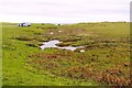
Neolithic and Bronze AgeSite Name: Kilkenneth CairnCountry: Scotland County: Isle of Tiree Type: Cairn
Map Ref: NL939445
Latitude: 56.492712N Longitude: 6.975313W
Condition:
| 5 | Perfect |
| 4 | Almost Perfect |
| 3 | Reasonable but with some damage |
| 2 | Ruined but still recognisable as an ancient site |
| 1 | Pretty much destroyed, possibly visible as crop marks |
| 0 | No data. |
| -1 | Completely destroyed |
| 5 | Superb |
| 4 | Good |
| 3 | Ordinary |
| 2 | Not Good |
| 1 | Awful |
| 0 | No data. |
| 5 | Can be driven to, probably with disabled access |
| 4 | Short walk on a footpath |
| 3 | Requiring a bit more of a walk |
| 2 | A long walk |
| 1 | In the middle of nowhere, a nightmare to find |
| 0 | No data. |
| 5 | co-ordinates taken by GPS or official recorded co-ordinates |
| 4 | co-ordinates scaled from a detailed map |
| 3 | co-ordinates scaled from a bad map |
| 2 | co-ordinates of the nearest village |
| 1 | co-ordinates of the nearest town |
| 0 | no data |
Internal Links:
External Links:
I have visited· I would like to visit
Bladup has visited here
")
A nice intact cairn hidden amongst the sand dunes, I don't know how we found it, but we did.
You may be viewing yesterday's version of this page. To see the most up to date information please register for a free account.
Do not use the above information on other web sites or publications without permission of the contributor.
Nearby Images from Geograph Britain and Ireland:
©2009(licence)
©2023(licence)
©2023(licence)
©2023(licence)
©2023(licence)
The above images may not be of the site on this page, they are loaded from Geograph.
Please Submit an Image of this site or go out and take one for us!
Click here to see more info for this site
Nearby sites
Key: Red: member's photo, Blue: 3rd party photo, Yellow: other image, Green: no photo - please go there and take one, Grey: site destroyed
Download sites to:
KML (Google Earth)
GPX (GPS waypoints)
CSV (Garmin/Navman)
CSV (Excel)
To unlock full downloads you need to sign up as a Contributory Member. Otherwise downloads are limited to 50 sites.
Turn off the page maps and other distractions
Nearby sites listing. In the following links * = Image available
1.7km SSE 148° Middleton Standing Stone (Isle of Tiree)* Standing Stone (Menhir) (NL94694300)
2.0km ENE 70° Hough - SSW* Stone Circle (NL95814504)
2.0km ENE 70° Hough Cairn* Cairn (NL95834505)
2.1km ENE 68° Hough - NNE* Stone Circle (NL95894515)
3.2km N 10° Dun Boraige Moire* Broch or Nuraghe (NL94684756)
3.2km NNE 15° Dun Boraige Beag* Stone Fort or Dun (NL94944757)
3.9km ESE 115° Ceasabh Standing stone* Standing Stone (Menhir) (NL97314259)
4.7km SSE 155° Dunan Nighean* Stone Fort or Dun (NL95594014)
5.0km SE 125° Cadruim* Rock Art (NL9782241299)
5.3km ENE 74° Kenovay Cup-Marked Rocks Rock Art (NL99064560)
6.1km SSE 152° Dun Hiader* Stone Fort or Dun (NL964389)
6.9km SE 146° Dun Na Cleite* Stone Fort or Dun (NL97403850)
8.5km ENE 78° Loch A Chapuil* Stone Circle (NM024456)
8.7km E 87° Dun Ibrig* Stone Fort or Dun (NM02594440)
9.1km E 83° Loch A' Bhleoghan* Stone Circle (NM030450)
9.7km E 81° Beinn Ghott* Cairn (NM03594540)
9.7km ENE 60° Tiree Ringing Rock* Natural Stone / Erratic / Other Natural Feature (NM02684869)
10.0km E 92° Dun Heanish* Stone Fort or Dun (NM039434)
10.7km E 80° Dun Ghott* Stone Fort or Dun (NM04584567)
11.3km ENE 61° Dun Mor Vaul* Broch or Nuraghe (NM04234927)
11.7km ENE 62° Dun Beag (Vaul)* Stone Fort or Dun (NM04634926)
14.3km ENE 70° Caolas Standing Stone* Standing Stone (Menhir) (NM07744835)
14.8km ENE 74° Dun Mor A'Chaolais* Broch or Nuraghe (NM084476)
23.0km ENE 63° Traigh Chrossapol Standing Stone (Menhir) (NM1518853301)
25.4km ENE 59° Totronald* Standing Stones (NM1666455985)
View more nearby sites and additional images


 We would like to know more about this location. Please feel free to add a brief description and any relevant information in your own language.
 Wir möchten mehr über diese Stätte erfahren. Bitte zögern Sie nicht, eine kurze Beschreibung und relevante Informationen in Deutsch hinzuzufügen.
 Nous aimerions en savoir encore un peu sur les lieux. S'il vous plaît n'hesitez pas à ajouter une courte description et tous les renseignements pertinents dans votre propre langue.
 Quisieramos informarnos un poco más de las lugares. No dude en añadir una breve descripción y otros datos relevantes en su propio idioma.