

<< Our Photo Pages >> Lindern Steinkiste - Cist in Germany in Lower Saxony, Bremen
Submitted by holger_rix on Monday, 23 July 2012 Page Views: 1897
Neolithic and Bronze AgeSite Name: Lindern SteinkisteCountry: Germany Land: Lower Saxony, Bremen Type: Cist
Nearest Village: Lindern
Latitude: 52.851124N Longitude: 7.774612E
Condition:
| 5 | Perfect |
| 4 | Almost Perfect |
| 3 | Reasonable but with some damage |
| 2 | Ruined but still recognisable as an ancient site |
| 1 | Pretty much destroyed, possibly visible as crop marks |
| 0 | No data. |
| -1 | Completely destroyed |
| 5 | Superb |
| 4 | Good |
| 3 | Ordinary |
| 2 | Not Good |
| 1 | Awful |
| 0 | No data. |
| 5 | Can be driven to, probably with disabled access |
| 4 | Short walk on a footpath |
| 3 | Requiring a bit more of a walk |
| 2 | A long walk |
| 1 | In the middle of nowhere, a nightmare to find |
| 0 | No data. |
| 5 | co-ordinates taken by GPS or official recorded co-ordinates |
| 4 | co-ordinates scaled from a detailed map |
| 3 | co-ordinates scaled from a bad map |
| 2 | co-ordinates of the nearest village |
| 1 | co-ordinates of the nearest town |
| 0 | no data |
Internal Links:
External Links:
I have visited· I would like to visit
johnstone visited on 14th Sep 2016 - their rating: Cond: 3 Amb: 4 Access: 4
Traumrealistin visited on 14th Oct 2015 - their rating: Cond: 4 Amb: 5 Access: 4 Nice place to visit with a nice and vibrant atmosphere.
Laird_Blonag have visited here
Average ratings for this site from all visit loggers: Condition: 3.5 Ambience: 4.5 Access: 4
")
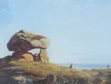
A 4 x 2m rectangle shaped cist chamber.
It was found in 1961. No capstones.
Set up with seven flat slabs plus one
perfectly shaped foundling on the short end.
Mentioned in Sprockhoffs Atlas Lastrup page 140.
Visit in winter !
Sadly overgrown.
You may be viewing yesterday's version of this page. To see the most up to date information please register for a free account.
")
")
")
")
")
")
Do not use the above information on other web sites or publications without permission of the contributor.
Click here to see more info for this site
Nearby sites
Click here to view sites on an interactive map of the areaKey: Red: member's photo, Blue: 3rd party photo, Yellow: other image, Green: no photo - please go there and take one, Grey: site destroyed
Download sites to:
KML (Google Earth)
GPX (GPS waypoints)
CSV (Garmin/Navman)
CSV (Excel)
To unlock full downloads you need to sign up as a Contributory Member. Otherwise downloads are limited to 50 sites.
Turn off the page maps and other distractions
Nearby sites listing. In the following links * = Image available
91m NE 54° Lindern Dolmen (modern)* Natural Stone / Erratic / Other Natural Feature
1.1km NW 323° Lindern Schlingsteine* Chambered Tomb
1.7km SW 226° Lindern Herrensand Huegelgraeberfeld* Barrow Cemetery
1.8km SW 225° Lindern Herrensand Huenensteine* Chambered Tomb
5.1km SSW 198° Garen Steingrab 'Der Hohe Stein'* Chambered Tomb
5.1km SSW 200° Garen Steingrab 'Am Hohen Stein'* Chambered Tomb
5.8km NNE 27° Bischofsbrueck Teufelssteine* Chambered Tomb
6.0km NNE 30° Bischofsbrück 2* Chambered Tomb
6.5km N 352° Plingenberger Steine Grosssteingrab* Chambered Tomb
7.0km WNW 298° Werlte Steingrab 'De Hoogen Stener'* Chambered Tomb
8.3km SSE 153° Oldendorfer Huenensteine* Chambered Tomb
8.4km SSE 159° Oldendorfer Fuhrenkamp (1)* Chambered Tomb
8.4km SSE 158° Oldendorfer Fuhrenkamp (2)* Chambered Tomb
8.5km SSE 158° Oldendorfer Fuhrenkamp (3)* Chambered Tomb
8.5km SE 130° Lastrup Steingrab (1)* Chambered Tomb
8.5km SE 130° Lastrup Steingrab (2)* Chambered Tomb
8.7km SSW 212° Wachtum Steingrab* Chambered Tomb
9.4km WSW 253° Lahn Steingrab 3* Chambered Tomb
9.5km WNW 290° Harrenstaette Poldenhuenensteine* Chambered Tomb
9.9km WSW 253° Lahn Steingrab 1 Chambered Tomb
10.0km WSW 253° Lahn Steingrab 2* Chambered Tomb
12.1km W 265° Ostenwalde Steingrab 3* Chambered Tomb
12.5km W 263° Ostenwalde Steingrab 1* Passage Grave
12.6km W 263° Ostenwalde Steingrab 2* Chambered Tomb
12.8km WNW 283° Steenberg Spahn* Passage Grave
View more nearby sites and additional images


 We would like to know more about this location. Please feel free to add a brief description and any relevant information in your own language.
 Wir möchten mehr über diese Stätte erfahren. Bitte zögern Sie nicht, eine kurze Beschreibung und relevante Informationen in Deutsch hinzuzufügen.
 Nous aimerions en savoir encore un peu sur les lieux. S'il vous plaît n'hesitez pas à ajouter une courte description et tous les renseignements pertinents dans votre propre langue.
 Quisieramos informarnos un poco más de las lugares. No dude en añadir una breve descripción y otros datos relevantes en su propio idioma.