

<< Our Photo Pages >> Carrowmore 57 - Stone Circle in Ireland (Republic of) in Co. Sligo
Submitted by Tom_Bullock on Sunday, 14 July 2002 Page Views: 6445
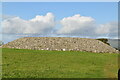
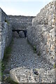
Neolithic and Bronze AgeSite Name: Carrowmore 57Country: Ireland (Republic of) County: Co. Sligo Type: Stone Circle
Map Ref: G662335
Discovery Map Number: D25
Latitude: 54.249274N Longitude: 8.519266W
Condition:
| 5 | Perfect |
| 4 | Almost Perfect |
| 3 | Reasonable but with some damage |
| 2 | Ruined but still recognisable as an ancient site |
| 1 | Pretty much destroyed, possibly visible as crop marks |
| 0 | No data. |
| -1 | Completely destroyed |
| 5 | Superb |
| 4 | Good |
| 3 | Ordinary |
| 2 | Not Good |
| 1 | Awful |
| 0 | No data. |
| 5 | Can be driven to, probably with disabled access |
| 4 | Short walk on a footpath |
| 3 | Requiring a bit more of a walk |
| 2 | A long walk |
| 1 | In the middle of nowhere, a nightmare to find |
| 0 | No data. |
| 5 | co-ordinates taken by GPS or official recorded co-ordinates |
| 4 | co-ordinates scaled from a detailed map |
| 3 | co-ordinates scaled from a bad map |
| 2 | co-ordinates of the nearest village |
| 1 | co-ordinates of the nearest town |
| 0 | no data |
Internal Links:
External Links:
I have visited· I would like to visit
jeffrep visited on 28th Jul 2009 - their rating: Cond: 3 Amb: 3 Access: 5
")
Have you visited this site? Please add a comment below.
You may be viewing yesterday's version of this page. To see the most up to date information please register for a free account.
")
")
Do not use the above information on other web sites or publications without permission of the contributor.
Nearby Images from Geograph Britain and Ireland:
©2019(licence)
©2022(licence)
©2022(licence)
©2022(licence)
©2022(licence)
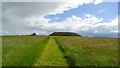
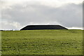
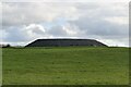
The above images may not be of the site on this page, they are loaded from Geograph.
Please Submit an Image of this site or go out and take one for us!
Click here to see more info for this site
Nearby sites
Click here to view sites on an interactive map of the areaKey: Red: member's photo, Blue: 3rd party photo, Yellow: other image, Green: no photo - please go there and take one, Grey: site destroyed
Download sites to:
KML (Google Earth)
GPX (GPS waypoints)
CSV (Garmin/Navman)
CSV (Excel)
To unlock full downloads you need to sign up as a Contributory Member. Otherwise downloads are limited to 50 sites.
Turn off the page maps and other distractions
Nearby sites listing. In the following links * = Image available
0m E 90° Carrowmore 57 Passage Grave (G662335)
64m SE 141° Carrowmore 51 (Listoghil)* Passage Grave (G66243345)
100m W 270° Carrowmore 53* Chambered Tomb (G661335)
100m E 90° Carrowmore 9* Stone Circle (G663335)
100m E 90° Carrowmore 11* Stone Circle (G663335)
100m E 90° Carrowmore 26* Stone Circle (G663335)
100m N 360° Carrowmore 54* Passage Grave (G662336)
100m N 360° Carrowmore 55* Passage Grave (G662336)
100m N 360° Carrowmore 52* Passage Grave (G662336)
200m N 360° Carrowmore 4.* Passage Grave (G662337)
206m N 4° Carrowmore* Passage Grave (G6621633706)
211m N 351° Carrowmore 1.* Passage Grave
223m NNW 333° Carrowmore 2.* Passage Grave (G661337)
223m SSW 206° Carrowmore 48* Passage Grave (G661333)
238m NE 36° Carrowmore 59* Burial Chamber or Dolmen
282m SW 225° Carrowmore 52a* Passage Grave (G660333)
300m N 360° Carrowmore 5.* Passage Grave (G662338)
317m ENE 77° Carrowmore 18* Passage Grave
371m NNE 34° Carrowmore 13* Burial Chamber or Dolmen
398m SE 126° Carrowmore 27* Passage Grave
412m NNE 14° Carrowmore 7* Passage Grave (G663339)
3.7km WNW 286° Knocknarea* Passage Grave (G6260434583)
3.8km WNW 288° Knocknarea-North* Passage Grave (G62613470)
4.4km ENE 59° Abbeyquarter* Chambered Tomb (G7002835741)
5.5km SW 230° Tanrego Bay Stone Circle (G6230)
View more nearby sites and additional images


 We would like to know more about this location. Please feel free to add a brief description and any relevant information in your own language.
 Wir möchten mehr über diese Stätte erfahren. Bitte zögern Sie nicht, eine kurze Beschreibung und relevante Informationen in Deutsch hinzuzufügen.
 Nous aimerions en savoir encore un peu sur les lieux. S'il vous plaît n'hesitez pas à ajouter une courte description et tous les renseignements pertinents dans votre propre langue.
 Quisieramos informarnos un poco más de las lugares. No dude en añadir una breve descripción y otros datos relevantes en su propio idioma.