 with our Megalithic Portal iPhone app")


<< Our Photo Pages >> Baurgorm SW - Stone Circle in Ireland (Republic of) in Co. Cork
Submitted by frogcottage42 on Tuesday, 08 October 2002 Page Views: 5962
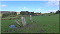
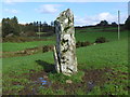
Neolithic and Bronze AgeSite Name: Baurgorm SWCountry: Ireland (Republic of) County: Co. Cork Type: Stone Circle
Nearest Town: Bantry
Map Ref: W01554595
Discovery Map Number: D85
Latitude: 51.657966N Longitude: 9.423391W
Condition:
| 5 | Perfect |
| 4 | Almost Perfect |
| 3 | Reasonable but with some damage |
| 2 | Ruined but still recognisable as an ancient site |
| 1 | Pretty much destroyed, possibly visible as crop marks |
| 0 | No data. |
| -1 | Completely destroyed |
| 5 | Superb |
| 4 | Good |
| 3 | Ordinary |
| 2 | Not Good |
| 1 | Awful |
| 0 | No data. |
| 5 | Can be driven to, probably with disabled access |
| 4 | Short walk on a footpath |
| 3 | Requiring a bit more of a walk |
| 2 | A long walk |
| 1 | In the middle of nowhere, a nightmare to find |
| 0 | No data. |
| 5 | co-ordinates taken by GPS or official recorded co-ordinates |
| 4 | co-ordinates scaled from a detailed map |
| 3 | co-ordinates scaled from a bad map |
| 2 | co-ordinates of the nearest village |
| 1 | co-ordinates of the nearest town |
| 0 | no data |
Internal Links:
External Links:
I have visited· I would like to visit
frogcottage42 has visited here
")
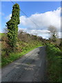
Surrounded by dense gorse and invisible from anywhere more than 50m away it is difficult to access.
You may be viewing yesterday's version of this page. To see the most up to date information please register for a free account.
")
Do not use the above information on other web sites or publications without permission of the contributor.
Nearby Images from Geograph Britain and Ireland:
©2017(licence)
©2017(licence)
©2017(licence)
©2005(licence)
©2017(licence)
The above images may not be of the site on this page, they are loaded from Geograph.
Please Submit an Image of this site or go out and take one for us!
Click here to see more info for this site
Nearby sites
Click here to view sites on an interactive map of the areaKey: Red: member's photo, Blue: 3rd party photo, Yellow: other image, Green: no photo - please go there and take one, Grey: site destroyed
Download sites to:
KML (Google Earth)
GPX (GPS waypoints)
CSV (Garmin/Navman)
CSV (Excel)
To unlock full downloads you need to sign up as a Contributory Member. Otherwise downloads are limited to 50 sites.
Turn off the page maps and other distractions
Nearby sites listing. In the following links * = Image available
224m ENE 72° Cullomane West* Stone Row / Alignment (W0176546014)
673m W 270° Doirín Grianach standing stone and stone group* Standing Stone (Menhir)
1.3km NE 36° Baurgaum.* Stone Circle (W02314695)
1.4km W 269° Scartbaun stone row* Stone Row / Alignment
1.4km NNW 345° Derreengreanagh wedge tomb* Wedge Tomb
2.1km ESE 104° Cullomane E* Stone Circle (W03634540)
2.4km WSW 251° Keilnascarta* Stone Row / Alignment (V99314521)
2.5km SW 226° Parkana Stone Row / Alignment (V99694423)
3.2km NE 55° Trawlebane* Stone Circle (W04214773)
3.3km E 88° Inchybegga* Stone Circle (W04834600)
3.4km WNW 296° St Brendan's Stone (Kilnaruane)* Early Christian Sculptured Stone
4.5km E 92° Dromore (Cork)* Standing Stone (Menhir)
4.6km WSW 238° Ballycommane Standing Stones (V97634361)
4.6km WSW 241° Maulinward Stone Row / Alignment (V975438)
5.9km S 191° Derreennaclogh Rock Art* Rock Art
7.3km S 177° Ballybane* Rock Art (W0183738669)
7.4km N 359° Crossoge wedge tomb* Wedge Tomb
7.5km NNE 13° Cappanaboul* Stone Circle (W0343753265)
7.8km NE 52° Coomanore South* Standing Stones
8.6km N 351° Dromkeal* Stone Circle (W00315445)
8.6km NNE 24° Derryarkane Stone Circle (W05255374)
9.5km SSE 165° Lissaclarig West Stone Row / Alignment (W039367)
9.5km S 171° Murrahin North* Stone Row / Alignment (W029365)
9.6km SSE 164° Lissaclarig East Stone Row / Alignment (W04013670)
9.6km E 90° Dromasta* Standing Stones (W1114845834)
View more nearby sites and additional images


 We would like to know more about this location. Please feel free to add a brief description and any relevant information in your own language.
 Wir möchten mehr über diese Stätte erfahren. Bitte zögern Sie nicht, eine kurze Beschreibung und relevante Informationen in Deutsch hinzuzufügen.
 Nous aimerions en savoir encore un peu sur les lieux. S'il vous plaît n'hesitez pas à ajouter une courte description et tous les renseignements pertinents dans votre propre langue.
 Quisieramos informarnos un poco más de las lugares. No dude en añadir una breve descripción y otros datos relevantes en su propio idioma.