


<< Our Photo Pages >> Jacob's Well (Portland) - Holy Well or Sacred Spring in England in Dorset
Submitted by jamesrattue on Monday, 05 September 2011 Page Views: 8499
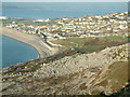
Springs and Holy WellsSite Name: Jacob's Well (Portland)Country: England County: Dorset Type: Holy Well or Sacred Spring
Nearest Town: Weymouth Nearest Village: Fortuneswell
Map Ref: SY683730
Latitude: 50.555891N Longitude: 2.448851W
Condition:
| 5 | Perfect |
| 4 | Almost Perfect |
| 3 | Reasonable but with some damage |
| 2 | Ruined but still recognisable as an ancient site |
| 1 | Pretty much destroyed, possibly visible as crop marks |
| 0 | No data. |
| -1 | Completely destroyed |
| 5 | Superb |
| 4 | Good |
| 3 | Ordinary |
| 2 | Not Good |
| 1 | Awful |
| 0 | No data. |
| 5 | Can be driven to, probably with disabled access |
| 4 | Short walk on a footpath |
| 3 | Requiring a bit more of a walk |
| 2 | A long walk |
| 1 | In the middle of nowhere, a nightmare to find |
| 0 | No data. |
| 5 | co-ordinates taken by GPS or official recorded co-ordinates |
| 4 | co-ordinates scaled from a detailed map |
| 3 | co-ordinates scaled from a bad map |
| 2 | co-ordinates of the nearest village |
| 1 | co-ordinates of the nearest town |
| 0 | no data |
Internal Links:
External Links:
I have visited· I would like to visit
Ogham visited on 8th Mar 2002 - their rating: Cond: 3 Amb: 4 Access: 4
 (PID:81509)")
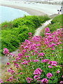
Apparently this was the name given to the spring by Hiram Otter (1833-1915), the Portland fisherman who laid out the path along the coast here and was well-known for decorating the rocks with Biblical verses and names, none of which now survive - hence the rocky cove just down the footpath is dubbed Hallelujah Bay.
You may be viewing yesterday's version of this page. To see the most up to date information please register for a free account.
Do not use the above information on other web sites or publications without permission of the contributor.
Nearby Images from Geograph Britain and Ireland:
©2010(licence)
©2010(licence)
©2019(licence)
©2020(licence)
©2007(licence)
The above images may not be of the site on this page, they are loaded from Geograph.
Please Submit an Image of this site or go out and take one for us!
Click here to see more info for this site
Nearby sites
Key: Red: member's photo, Blue: 3rd party photo, Yellow: other image, Green: no photo - please go there and take one, Grey: site destroyed
Download sites to:
KML (Google Earth)
GPX (GPS waypoints)
CSV (Garmin/Navman)
CSV (Excel)
To unlock full downloads you need to sign up as a Contributory Member. Otherwise downloads are limited to 50 sites.
Turn off the page maps and other distractions
Nearby sites listing. In the following links * = Image available
318m ESE 122° Tout Quarry Sculpture Park Alignment* Modern Stone Circle etc (SY68577283)
461m ESE 107° Tout Quarry Sculpture Park Stone Circle* Modern Stone Circle etc (SY68747286)
528m S 170° Tout Quarry Sculpture Park - The Circle of Stones* Modern Stone Circle etc (SY68397248)
816m ESE 108° Kingbarrow Modern Stone Circle etc (SY6907772745)
2.1km ESE 109° Grove Road* Stone Circle (SY703723)
3.7km S 177° Culverwell Mesolithic Site* Ancient Village or Settlement (SY685693)
4.8km S 189° Pulpit Rock (Portland)* Rock Outcrop (SY675683)
5.1km N 351° Dripping Well (Weymouth) Holy Well or Sacred Spring (SY6750478079)
10.9km N 6° Chalbury* Hillfort (SY695838)
11.6km NE 34° Southdown (Dorset)* Barrow Cemetery (SY749825)
11.7km N 3° Bincombe Barrows* Barrow Cemetery (SY689847)
12.1km NNE 12° Northdown (Dorset)* Barrow Cemetery (SY708848)
12.3km NNE 30° Poxwell Cairn* Cairn (SY74518357)
12.4km N 349° Upwey Wishing Well* Holy Well or Sacred Spring (SY661852)
12.4km N 8° Broadmayne Bank Barrow* Long Barrow (SY702853)
12.7km N 358° Bincombe Down* Barrow Cemetery (SY679857)
12.8km N 355° Ridgeway Hill* Barrow Cemetery (SY672858)
12.9km N 7° Whitcombe 1* Long Barrow (SY699858)
12.9km NE 50° Chaldon Down* Barrow Cemetery (SY783812)
13.0km N 358° Winterborne Came 18b (Bincombe) Cairn (SY680860)
13.2km NNW 341° Friar Waddon Hill Barrow Cemetery (SY641855)
13.3km N 1° Came Down* Barrow Cemetery (SY687863)
13.7km N 351° Upwey Ridgeway* Barrow Cemetery (SY66298659)
13.8km NE 53° Wardstone Barrow* Round Barrow(s) (SY79338133)
14.1km NNW 345° Ridge Hill* Barrow Cemetery (SY648867)
View more nearby sites and additional images


 We would like to know more about this location. Please feel free to add a brief description and any relevant information in your own language.
 Wir möchten mehr über diese Stätte erfahren. Bitte zögern Sie nicht, eine kurze Beschreibung und relevante Informationen in Deutsch hinzuzufügen.
 Nous aimerions en savoir encore un peu sur les lieux. S'il vous plaît n'hesitez pas à ajouter une courte description et tous les renseignements pertinents dans votre propre langue.
 Quisieramos informarnos un poco más de las lugares. No dude en añadir una breve descripción y otros datos relevantes en su propio idioma.