

<< Our Photo Pages >> Hothers Høj - Round Barrow(s) in Denmark in Sjælland
Submitted by praeceptor on Sunday, 14 August 2011 Page Views: 4270
Neolithic and Bronze AgeSite Name: Hothers Høj Alternative Name: Kongehøj, KirkehøjCountry: Denmark County: Sjælland Type: Round Barrow(s)
Nearest Town: Køge Nearest Village: Hårlev
Latitude: 55.348500N Longitude: 12.241400E
Condition:
| 5 | Perfect |
| 4 | Almost Perfect |
| 3 | Reasonable but with some damage |
| 2 | Ruined but still recognisable as an ancient site |
| 1 | Pretty much destroyed, possibly visible as crop marks |
| 0 | No data. |
| -1 | Completely destroyed |
| 5 | Superb |
| 4 | Good |
| 3 | Ordinary |
| 2 | Not Good |
| 1 | Awful |
| 0 | No data. |
| 5 | Can be driven to, probably with disabled access |
| 4 | Short walk on a footpath |
| 3 | Requiring a bit more of a walk |
| 2 | A long walk |
| 1 | In the middle of nowhere, a nightmare to find |
| 0 | No data. |
| 5 | co-ordinates taken by GPS or official recorded co-ordinates |
| 4 | co-ordinates scaled from a detailed map |
| 3 | co-ordinates scaled from a bad map |
| 2 | co-ordinates of the nearest village |
| 1 | co-ordinates of the nearest town |
| 0 | no data |
Internal Links:
External Links:
I have visited· I would like to visit
Boeddel visited on 10th Aug 2023 - their rating: Amb: 3 Access: 4
combuijs visited on 11th Jul 2015 - their rating: Cond: 2 Amb: 4 Access: 5 On road 209 from Faxe to Køge in the village of Hårlev near the church on the west (left) side of the road. Parking places available.
praeceptor visited on 15th Aug 2011 - their rating: Cond: 2 Amb: 4 Access: 4 According to the cemetery sexton the stones at the top of the mound are believed to be residues from an earlier church that once was situated on the top of the mound.
Average ratings for this site from all visit loggers: Condition: 2 Ambience: 3.67 Access: 4.33
")
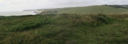
Large mound placed inside the churchyard/cemetery. Part of the mound has been modified. On the flattened top some stones are placed - from the pictures in the official description it isn't possible to determine if these are from an ancient tomb, or if it - more likely - is a collection of expired headstones from our time, a so-called Lapidarium.
Official description: http://www.kulturarv.dk/fundogfortidsminder/Lokalitet/87956/
You may be viewing yesterday's version of this page. To see the most up to date information please register for a free account.
")
")
")
")
")
")
")
")
")
")
")
")
")
")
")
Do not use the above information on other web sites or publications without permission of the contributor.
Click here to see more info for this site
Nearby sites
Click here to view sites on an interactive map of the areaKey: Red: member's photo, Blue: 3rd party photo, Yellow: other image, Green: no photo - please go there and take one, Grey: site destroyed
Download sites to:
KML (Google Earth)
GPX (GPS waypoints)
CSV (Garmin/Navman)
CSV (Excel)
To unlock full downloads you need to sign up as a Contributory Member. Otherwise downloads are limited to 50 sites.
Turn off the page maps and other distractions
Nearby sites listing. In the following links * = Image available
2.0km ESE 111° Hellested Maglehøj Jættestue* Passage Grave
3.5km S 181° Hellested Elverhøj* Round Barrow(s)
6.6km NW 304° Gunderup Kohave Jættestue* Passage Grave
8.0km NE 52° Magleby Skov Langdysse Long Barrow
8.4km NW 305° Tessebølle Runddysse* Burial Chamber or Dolmen
11.8km SSW 203° Stubberup Skov Junkershøj Langdysse* Long Barrow
12.0km SSE 158° Lund Jættestue Passage Grave
12.2km SE 138° Skørpinge Rundhøj* Round Barrow(s)
12.4km SSE 148° Havnelev Rundhøj* Round Barrow(s)
12.6km W 279° Ingelstrup Stengrav* Burial Chamber or Dolmen
12.8km W 277° Ingelstrup Stenkildedyssen* Long Barrow
12.8km SSE 162° Stubbehøj Rundhøj* Round Barrow(s)
13.5km SW 228° Faxe Megalitgrav* Burial Chamber or Dolmen
13.8km NNW 341° Gammel Køgegård Rundhøj 5* Round Barrow(s)
13.8km SSW 201° Troldhøj Brandskov Rundhøj* Round Barrow(s)
14.0km W 265° Holtegård Langdysse Long Barrow
14.3km NNW 339° Gammel Køgegård Rundhøj 3* Round Barrow(s)
14.3km NNW 339° Gammel Køgegård Rundhøj 4* Round Barrow(s)
14.5km NNW 339° Gammel Køgegård Rundhøj 1* Round Barrow(s)
14.6km NNW 339° Gammel Køgegård Rundhøj 2* Round Barrow(s)
16.0km WNW 290° Årløse Runddysse* Burial Chamber or Dolmen
16.7km WSW 247° Nielstrup Langdysse* Long Barrow
16.9km WNW 292° Gørslev Jættestue* Passage Grave
17.0km SW 231° Kongsted Runddysse* Burial Chamber or Dolmen
18.0km SSW 202° Strandegård dyrehave Rundhøj Nord* Round Barrow(s)
View more nearby sites and additional images


 We would like to know more about this location. Please feel free to add a brief description and any relevant information in your own language.
 Wir möchten mehr über diese Stätte erfahren. Bitte zögern Sie nicht, eine kurze Beschreibung und relevante Informationen in Deutsch hinzuzufügen.
 Nous aimerions en savoir encore un peu sur les lieux. S'il vous plaît n'hesitez pas à ajouter une courte description et tous les renseignements pertinents dans votre propre langue.
 Quisieramos informarnos un poco más de las lugares. No dude en añadir una breve descripción y otros datos relevantes en su propio idioma.