 with our Megalithic Portal iPhone app")


<< Our Photo Pages >> Roc de Cazelle - Ancient Village or Settlement in France in Aquitaine:Dordogne (24)
Submitted by theCaptain on Wednesday, 12 January 2011 Page Views: 5078
Multi-periodSite Name: Roc de CazelleCountry: France Département: Aquitaine:Dordogne (24) Type: Ancient Village or Settlement
Nearest Town: Sarlat-la-Canéda Nearest Village: Les Eyzies
Latitude: 44.941000N Longitude: 1.063000E
Condition:
| 5 | Perfect |
| 4 | Almost Perfect |
| 3 | Reasonable but with some damage |
| 2 | Ruined but still recognisable as an ancient site |
| 1 | Pretty much destroyed, possibly visible as crop marks |
| 0 | No data. |
| -1 | Completely destroyed |
| 5 | Superb |
| 4 | Good |
| 3 | Ordinary |
| 2 | Not Good |
| 1 | Awful |
| 0 | No data. |
| 5 | Can be driven to, probably with disabled access |
| 4 | Short walk on a footpath |
| 3 | Requiring a bit more of a walk |
| 2 | A long walk |
| 1 | In the middle of nowhere, a nightmare to find |
| 0 | No data. |
| 5 | co-ordinates taken by GPS or official recorded co-ordinates |
| 4 | co-ordinates scaled from a detailed map |
| 3 | co-ordinates scaled from a bad map |
| 2 | co-ordinates of the nearest village |
| 1 | co-ordinates of the nearest town |
| 0 | no data |
Internal Links:
External Links:
I have visited· I would like to visit
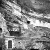
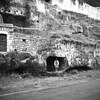
TheCaptain visited on 2nd Jun 2005 - their rating: Access: 4 This place has been inhabited since 40000 years ago right up until the 1960’s when the last farmer and his wife moved on. It is an overhanging cliff with several levels of caves and shelters and these days is a little visitor park showing life in the troglodytic fashion since prehistoric times with many little scenes recreated and artisans demonstrating their trades and crafts.
")
It is an overhanging cliff with several levels of caves and shelters and these days is a little visitor park showing life in the troglodytic fashion since prehistoric times with many little scenes recreated and artisans demonstrating their trades and crafts.
You may be viewing yesterday's version of this page. To see the most up to date information please register for a free account.
")
Do not use the above information on other web sites or publications without permission of the contributor.
Nearby Images from Flickr
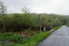


The above images may not be of the site on this page, but were taken nearby. They are loaded from Flickr so please click on them for image credits.
Click here to see more info for this site
Nearby sites
Click here to view sites on an interactive map of the areaKey: Red: member's photo, Blue: 3rd party photo, Yellow: other image, Green: no photo - please go there and take one, Grey: site destroyed
Download sites to:
KML (Google Earth)
GPX (GPS waypoints)
CSV (Garmin/Navman)
CSV (Excel)
To unlock full downloads you need to sign up as a Contributory Member. Otherwise downloads are limited to 50 sites.
Turn off the page maps and other distractions
Nearby sites listing. In the following links * = Image available
1.2km SSE 161° Grotte de Bernifal* Cave or Rock Shelter
1.7km SSE 155° Grotte dite Sous le Grand Lac Cave or Rock Shelter
1.7km W 280° Grotte des Combarelles 1* Cave or Rock Shelter
1.7km WNW 281° Grotte des Combarelles II* Cave or Rock Shelter
2.2km ENE 77° Abri de la Grèze Cave or Rock Shelter
2.7km E 79° Abri du Cap-Blanc* Cave or Rock Shelter
2.8km WSW 257° Font-de-Gaume* Cave or Rock Shelter
3.0km E 87° Grotte de Commarque* Cave or Rock Shelter
3.5km ENE 79° Abri de Laussel* Cave or Rock Shelter
3.7km WSW 258° Grotte de la Croze* Cave or Rock Shelter
3.7km WSW 258° Grotte d'Abzac Cave or Rock Shelter
3.8km WSW 241° Grotte de la Mouthe* Cave or Rock Shelter
3.9km NW 322° Village de la Madeleine* Ancient Village or Settlement
3.9km W 262° Musée National de Préhistoire* Museum
4.0km NW 320° Source de la Madeleine* Holy Well or Sacred Spring
4.0km NW 318° Abri de la Madeleine* Cave or Rock Shelter
4.0km N 352° Grotte de La Forêt Cave or Rock Shelter
4.0km W 265° Gisement du Pataud* Cave or Rock Shelter
4.2km W 269° Abri de Cro-Magnon* Cave or Rock Shelter
4.8km WNW 293° Gisement de la Micoque* Cave or Rock Shelter
4.9km WNW 286° Abri de Laugerie-Haute* Cave or Rock Shelter
5.0km W 272° Grotte de l'Oreille d'Enfer* Cave or Rock Shelter
5.1km SW 236° La Combe cave* Cave or Rock Shelter
5.1km W 274° Abri du Poisson* Cave or Rock Shelter
5.1km W 273° Abri de Lartet* Cave or Rock Shelter
View more nearby sites and additional images


 We would like to know more about this location. Please feel free to add a brief description and any relevant information in your own language.
 Wir möchten mehr über diese Stätte erfahren. Bitte zögern Sie nicht, eine kurze Beschreibung und relevante Informationen in Deutsch hinzuzufügen.
 Nous aimerions en savoir encore un peu sur les lieux. S'il vous plaît n'hesitez pas à ajouter une courte description et tous les renseignements pertinents dans votre propre langue.
 Quisieramos informarnos un poco más de las lugares. No dude en añadir una breve descripción y otros datos relevantes en su propio idioma.