


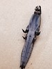
<< Our Photo Pages >> Bann Menhir 1 - Standing Stone (Menhir) in Germany in Rhineland-Palatinate
Submitted by KaiHofmann on Saturday, 11 December 2010 Page Views: 2888
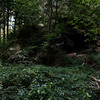
Neolithic and Bronze AgeSite Name: Bann Menhir 1Country: Germany Land: Rhineland-Palatinate Type: Standing Stone (Menhir)
Nearest Town: Landstuhl Nearest Village: Bann
Latitude: 49.402149N Longitude: 7.605854E
Condition:
| 5 | Perfect |
| 4 | Almost Perfect |
| 3 | Reasonable but with some damage |
| 2 | Ruined but still recognisable as an ancient site |
| 1 | Pretty much destroyed, possibly visible as crop marks |
| 0 | No data. |
| -1 | Completely destroyed |
| 5 | Superb |
| 4 | Good |
| 3 | Ordinary |
| 2 | Not Good |
| 1 | Awful |
| 0 | No data. |
| 5 | Can be driven to, probably with disabled access |
| 4 | Short walk on a footpath |
| 3 | Requiring a bit more of a walk |
| 2 | A long walk |
| 1 | In the middle of nowhere, a nightmare to find |
| 0 | No data. |
| 5 | co-ordinates taken by GPS or official recorded co-ordinates |
| 4 | co-ordinates scaled from a detailed map |
| 3 | co-ordinates scaled from a bad map |
| 2 | co-ordinates of the nearest village |
| 1 | co-ordinates of the nearest town |
| 0 | no data |
Internal Links:
External Links:
")
You may be viewing yesterday's version of this page. To see the most up to date information please register for a free account.
")
")
")
")
Do not use the above information on other web sites or publications without permission of the contributor.
Nearby Images from Flickr
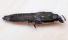
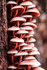
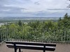

The above images may not be of the site on this page, but were taken nearby. They are loaded from Flickr so please click on them for image credits.
Click here to see more info for this site
Nearby sites
Click here to view sites on an interactive map of the areaKey: Red: member's photo, Blue: 3rd party photo, Yellow: other image, Green: no photo - please go there and take one, Grey: site destroyed
Download sites to:
KML (Google Earth)
GPX (GPS waypoints)
CSV (Garmin/Navman)
CSV (Excel)
To unlock full downloads you need to sign up as a Contributory Member. Otherwise downloads are limited to 50 sites.
Turn off the page maps and other distractions
Nearby sites listing. In the following links * = Image available
670m NE 37° Bann Menhir II* Standing Stone (Menhir)
1.3km NW 314° Heidenfelsquelle* Holy Well or Sacred Spring
4.4km ENE 64° Hoehensiedlung Einsiedlerhof Hillfort
4.6km WSW 250° Mittelbrunn Langer Stein* Standing Stone (Menhir)
7.3km ESE 107° Hinkelstein Breitenau* Standing Stone (Menhir)
7.7km NNE 20° Fürstengrab von Rodenbach* Artificial Mound
9.2km ENE 69° Hinkelstein Baennjerrueck* Standing Stone (Menhir)
9.5km SE 136° Schopp Huegelgraeber Barrow Cemetery
9.9km WSW 243° Römerstein* Standing Stone (Menhir)
11.9km ENE 64° Summstein Kaiserberg Modern Stone Circle etc
12.6km ENE 73° Hinkelstein Betzenberg Standing Stone (Menhir)
14.3km N 6° Teufelsstein Frankelbach Ancient Mine, Quarry or other Industry
15.5km WNW 292° Huegelgrab Steinbach Round Barrow(s)
16.0km N 3° Steinerner Mann Kaulbach Standing Stone (Menhir)
16.0km ENE 64° Meisental Menhir* Standing Stone (Menhir)
16.1km SSE 157° Heidelsburg Höhensiedlung* Hillfort
16.2km SSE 157° Foerster Saltarius und seine Gemahlin* Rock Art
16.3km ENE 59° Hochfels Mehlingen* Natural Stone / Erratic / Other Natural Feature
16.4km ENE 64° Steinlinie Meisenberg* Stone Row / Alignment
17.0km ENE 65° Steinallee Meisenberg* Multiple Stone Rows / Avenue
17.0km SW 232° St.Martin Wotankopf* Rock Art
17.3km ENE 58° Eichelberg Menhir* Standing Stone (Menhir)
17.7km N 6° Heidenburg Kreimberg Hillfort
18.3km W 262° Grabhuegel Waldmohr* Round Barrow(s)
18.6km ENE 71° Felsplatt Quaidersberg Natural Stone / Erratic / Other Natural Feature
View more nearby sites and additional images


 We would like to know more about this location. Please feel free to add a brief description and any relevant information in your own language.
 Wir möchten mehr über diese Stätte erfahren. Bitte zögern Sie nicht, eine kurze Beschreibung und relevante Informationen in Deutsch hinzuzufügen.
 Nous aimerions en savoir encore un peu sur les lieux. S'il vous plaît n'hesitez pas à ajouter une courte description et tous les renseignements pertinents dans votre propre langue.
 Quisieramos informarnos un poco más de las lugares. No dude en añadir una breve descripción y otros datos relevantes en su propio idioma.