


<< Our Photo Pages >> Pontsticill Inscribed Stone - Early Christian Sculptured Stone in Wales in Powys
Submitted by coldrum on Monday, 18 October 2010 Page Views: 9222
Early Medieval (Dark Age)Site Name: Pontsticill Inscribed Stone Alternative Name: Cum Criban Pillar StoneCountry: Wales County: Powys Type: Early Christian Sculptured Stone
Nearest Town: Merthyr Tyfil Nearest Village: Pontsticill
Map Ref: SO0726513176
Latitude: 51.809500N Longitude: 3.346518W
Condition:
| 5 | Perfect |
| 4 | Almost Perfect |
| 3 | Reasonable but with some damage |
| 2 | Ruined but still recognisable as an ancient site |
| 1 | Pretty much destroyed, possibly visible as crop marks |
| 0 | No data. |
| -1 | Completely destroyed |
| 5 | Superb |
| 4 | Good |
| 3 | Ordinary |
| 2 | Not Good |
| 1 | Awful |
| 0 | No data. |
| 5 | Can be driven to, probably with disabled access |
| 4 | Short walk on a footpath |
| 3 | Requiring a bit more of a walk |
| 2 | A long walk |
| 1 | In the middle of nowhere, a nightmare to find |
| 0 | No data. |
| 5 | co-ordinates taken by GPS or official recorded co-ordinates |
| 4 | co-ordinates scaled from a detailed map |
| 3 | co-ordinates scaled from a bad map |
| 2 | co-ordinates of the nearest village |
| 1 | co-ordinates of the nearest town |
| 0 | no data |
Internal Links:
External Links:
")
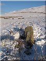
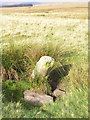
"The Pontsticill inscribed stone is a tall narrow monolith, 1.3m high, leaning at a slight angle. There are two inscriptions, one is indecipherable while the other, located on the South West corner is in Ogham; reading MAQI DECEDA. There is a recumbent slab next to it, possibly part of its base. Set in a slight hollow."
For more information see Coflein NPRN 92146. The Journal of Antiquities also features an entry for this stone - see the second listing on their page for Some Inscribed Stones in Wales. The Journal describes this as a pillar stone, probably dating to the 5th to 6th century AD; the stone was first discovered in 1694.
You may be viewing yesterday's version of this page. To see the most up to date information please register for a free account.
")
")
")
Do not use the above information on other web sites or publications without permission of the contributor.
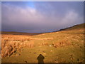
Nearby Images from Geograph Britain and Ireland:
©2010(licence)
©2010(licence)
©2010(licence)
©2010(licence)
©2005(licence)
The above images may not be of the site on this page, they are loaded from Geograph.
Please Submit an Image of this site or go out and take one for us!
Click here to see more info for this site
Nearby sites
Key: Red: member's photo, Blue: 3rd party photo, Yellow: other image, Green: no photo - please go there and take one, Grey: site destroyed
Download sites to:
KML (Google Earth)
GPX (GPS waypoints)
CSV (Garmin/Navman)
CSV (Excel)
To unlock full downloads you need to sign up as a Contributory Member. Otherwise downloads are limited to 50 sites.
Turn off the page maps and other distractions
Nearby sites listing. In the following links * = Image available
164m NNE 27° Cwm Criban Cairn (SO0734313320)
463m N 3° Buarth Y Caerau 2 Cairn (SO0729613638)
492m NW 320° Buarth Y Caerau Hut Circles Ancient Village or Settlement (SO0695213557)
1.0km W 277° Waun Rydd Cairn 1 Cairn (SO0625513310)
1.3km SSW 207° Abercriban Ciarn 1 Round Cairn (SO06651201)
1.6km ENE 73° Carn-Y-Bugail Cairn (SO0880613629)
1.7km ENE 70° Garn Felen Cairn (SO0885613724)
1.8km ENE 66° Garn Felen Enclosure 1 Ancient Village or Settlement (SO0889213878)
1.9km ENE 70° Garn Felen Enclosure 2 Ancient Village or Settlement (SO0902513791)
2.0km ESE 118° Odyn-fach Stone Circle (SO090122)
2.0km E 90° Twyn Ceiliog Cairn 2 Cairn (SO0931813155)
2.1km NW 319° Y Gaer Enclosure Hillfort (SO05931478)
2.1km NW 319° Y Gaer (Mid Glamorgan)* Hillfort (SO059148)
2.2km ESE 122° Garn Ddu Standing Stone Standing Stone (Menhir) (SO09111200)
2.2km ENE 61° Cwar-Y-Hendre Ancient Village or Settlement (SO092142)
2.3km NNE 28° Gwaun Nant Ddu Stone Standing Stone (Menhir) (SO0834815158)
2.3km N 4° Nany Y Ychen Cairn Cairn (SO0745215486)
2.4km NNE 30° Gwaun Nant Ddu Ancient Village or Settlement (SO0847615214)
2.4km NNE 18° Nany Y Ychen Misc. Earthwork (SO0804015447)
2.4km SW 234° Bryn Glas Cairns (Pontsticill)* Barrow Cemetery (SO05271177)
2.6km E 91° Twyn Ceiliog Round Cairn Cairn (SO0990813103)
4.6km ENE 58° Darren Ddu Enclosures Misc. Earthwork (SO112155)
4.7km E 91° Trefil-Las Round Barrow(s) (SO1213)
4.9km W 277° Nant Gwinau* Stone Row / Alignment (SO02361390)
5.0km NW 304° Bwlch Gwyn 2 Standing Stone (Menhir) (SO03151611)
View more nearby sites and additional images


 We would like to know more about this location. Please feel free to add a brief description and any relevant information in your own language.
 Wir möchten mehr über diese Stätte erfahren. Bitte zögern Sie nicht, eine kurze Beschreibung und relevante Informationen in Deutsch hinzuzufügen.
 Nous aimerions en savoir encore un peu sur les lieux. S'il vous plaît n'hesitez pas à ajouter une courte description et tous les renseignements pertinents dans votre propre langue.
 Quisieramos informarnos un poco más de las lugares. No dude en añadir una breve descripción y otros datos relevantes en su propio idioma.