


<< Our Photo Pages >> Quinish Cist - Cist in Scotland in Isle of Mull
Submitted by Andy B on Monday, 11 October 2010 Page Views: 4278
Neolithic and Bronze AgeSite Name: Quinish CistCountry: Scotland County: Isle of Mull Type: Cist
Map Ref: NM41505385
Latitude: 56.605025N Longitude: 6.213766W
Condition:
| 5 | Perfect |
| 4 | Almost Perfect |
| 3 | Reasonable but with some damage |
| 2 | Ruined but still recognisable as an ancient site |
| 1 | Pretty much destroyed, possibly visible as crop marks |
| 0 | No data. |
| -1 | Completely destroyed |
| 5 | Superb |
| 4 | Good |
| 3 | Ordinary |
| 2 | Not Good |
| 1 | Awful |
| 0 | No data. |
| 5 | Can be driven to, probably with disabled access |
| 4 | Short walk on a footpath |
| 3 | Requiring a bit more of a walk |
| 2 | A long walk |
| 1 | In the middle of nowhere, a nightmare to find |
| 0 | No data. |
| 5 | co-ordinates taken by GPS or official recorded co-ordinates |
| 4 | co-ordinates scaled from a detailed map |
| 3 | co-ordinates scaled from a bad map |
| 2 | co-ordinates of the nearest village |
| 1 | co-ordinates of the nearest town |
| 0 | no data |
Be the first person to rate this site - see the 'Contribute!' box in the right hand menu.
Internal Links:
External Links:
")
A food vessel, 5 1/2 ins high and 5 1/4 ins in diameter at the mouth, which was found in 1891 in a cist at Quinish (NM 415 542) is now in the National Museum of Antiquities of Scotland (NMAS) (Accession no: EE 72). It was donated by James A Forsyth, Quinish, in 1893.
Proc Soc Antiq Scot 1893; F R Coles 1903; RCAHMS 1980, visited 1972
Mr H Maclean (of Dervaig) indicated the findspot on the ground at NM 4150 5385. The cist was found while quarrying for gravel and the capstone is preserved in a flower bed by the front door of the house some 20m to the W.
Source: Canmore
You may be viewing yesterday's version of this page. To see the most up to date information please register for a free account.
Do not use the above information on other web sites or publications without permission of the contributor.
Nearby Images from Geograph Britain and Ireland:
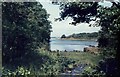
©2010(licence)
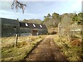
©2013(licence)
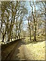
©2013(licence)
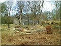
©2013(licence)

©2006(licence)
The above images may not be of the site on this page, they are loaded from Geograph.
Please Submit an Image of this site or go out and take one for us!
Click here to see more info for this site
Nearby sites
Key: Red: member's photo, Blue: 3rd party photo, Yellow: other image, Green: no photo - please go there and take one, Grey: site destroyed
Download sites to:
KML (Google Earth)
GPX (GPS waypoints)
CSV (Garmin/Navman)
CSV (Excel)
To unlock full downloads you need to sign up as a Contributory Member. Otherwise downloads are limited to 50 sites.
Turn off the page maps and other distractions
Nearby sites listing. In the following links * = Image available
1.4km N 350° Quinish (Stone Row)* Stone Row / Alignment (NM41355524)
1.9km SSW 198° Dun Auladh Round Cairn (NM40815212)
2.2km ESE 107° Maol Mor* Stone Row / Alignment (NM4360453056)
2.3km SE 142° Torr A'mhanaich Hillfort (NM42855192)
2.7km WSW 239° Dun Mhadaidh* Stone Fort or Dun (NM39145260)
2.9km NNE 30° An Sean Dun Stone Fort or Dun (NM43105624)
3.0km ESE 124° Dervaig centre* Stone Row / Alignment (NM43905203)
3.1km SE 125° Dervaig D Stone Row / Alignment (NM43935189)
3.1km SE 125° Dervaig 3* Standing Stones (NM43935189)
3.2km SE 129° Dervaig SSE* Stone Row / Alignment (NM4385951655)
3.2km SE 126° Priest's Well (Dervaig)* Holy Well or Sacred Spring (NM440518)
3.4km WSW 239° Calgary* Stone Row / Alignment (NM38495231)
3.4km SE 142° Aintuim Cairn Round Cairn (NM43445103)
3.8km W 261° Cillchriosd* Standing Stone (Menhir) (NM3772553502)
3.8km NNE 27° Glengorm* Stone Row / Alignment (NM43475713)
3.8km W 261° Cillchriosd Rock Art (NM37665347)
4.0km NNE 14° Dun Ara* Stone Fort or Dun (NM42725771)
4.1km SSE 156° Torr A'chlachain, Mull Hillfort (NM42945000)
4.6km W 259° Allt Cill Chriosd Stone Fort or Dun (NM36885328)
4.7km SE 141° Torr Aint* Hillfort (NM44265005)
5.2km W 261° Lag Standing Stones* Standing Stones (NM3626753307)
5.3km WSW 240° Calgary Pier Stone Fort or Dun (NM36705151)
5.7km W 269° Port Na Caillich Stone Fort or Dun (NM35785408)
7.1km SW 229° Creag A' Chaisteal Rock Art (NM35874957)
8.1km ENE 76° Dun Urgadul Stone Fort or Dun (NM49475527)
View more nearby sites and additional images


 We would like to know more about this location. Please feel free to add a brief description and any relevant information in your own language.
 Wir möchten mehr über diese Stätte erfahren. Bitte zögern Sie nicht, eine kurze Beschreibung und relevante Informationen in Deutsch hinzuzufügen.
 Nous aimerions en savoir encore un peu sur les lieux. S'il vous plaît n'hesitez pas à ajouter une courte description et tous les renseignements pertinents dans votre propre langue.
 Quisieramos informarnos un poco más de las lugares. No dude en añadir una breve descripción y otros datos relevantes en su propio idioma.