

<< Our Photo Pages >> Teufelsstein Heinersdorf - Rock Art in Germany in Brandenburg, Berlin
Submitted by KaiHofmann on Wednesday, 08 September 2010 Page Views: 4635
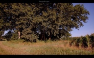
Rock ArtSite Name: Teufelsstein Heinersdorf Alternative Name: Schälchenstein HeinersdorfCountry: Germany Land: Brandenburg, Berlin Type: Rock Art
Nearest Town: Müncheberg Nearest Village: Heinersdorf
Latitude: 52.452300N Longitude: 14.223849E
Condition:
| 5 | Perfect |
| 4 | Almost Perfect |
| 3 | Reasonable but with some damage |
| 2 | Ruined but still recognisable as an ancient site |
| 1 | Pretty much destroyed, possibly visible as crop marks |
| 0 | No data. |
| -1 | Completely destroyed |
| 5 | Superb |
| 4 | Good |
| 3 | Ordinary |
| 2 | Not Good |
| 1 | Awful |
| 0 | No data. |
| 5 | Can be driven to, probably with disabled access |
| 4 | Short walk on a footpath |
| 3 | Requiring a bit more of a walk |
| 2 | A long walk |
| 1 | In the middle of nowhere, a nightmare to find |
| 0 | No data. |
| 5 | co-ordinates taken by GPS or official recorded co-ordinates |
| 4 | co-ordinates scaled from a detailed map |
| 3 | co-ordinates scaled from a bad map |
| 2 | co-ordinates of the nearest village |
| 1 | co-ordinates of the nearest town |
| 0 | no data |
Internal Links:
External Links:
I have visited· I would like to visit
DrewParsons would like to visit
Boeddel visited on 26th Oct 2017 - their rating: Access: 5
")
You may be viewing yesterday's version of this page. To see the most up to date information please register for a free account.
")
")
")
")
")
")
Do not use the above information on other web sites or publications without permission of the contributor.
Click here to see more info for this site
Nearby sites
Click here to view sites on an interactive map of the areaKey: Red: member's photo, Blue: 3rd party photo, Yellow: other image, Green: no photo - please go there and take one, Grey: site destroyed
Download sites to:
KML (Google Earth)
GPX (GPS waypoints)
CSV (Garmin/Navman)
CSV (Excel)
To unlock full downloads you need to sign up as a Contributory Member. Otherwise downloads are limited to 50 sites.
Turn off the page maps and other distractions
Nearby sites listing. In the following links * = Image available
4.9km SW 235° Tempelberg Steinkistengrab* Chambered Tomb
5.0km S 177° Arensdorf Wallanlage Ancient Village or Settlement
7.8km NW 316° Muencheberg Kreuz Early Christian Sculptured Stone
13.3km ENE 61° Naepfchenstein Friedersdorf* Rock Art
13.9km NW 314° Waldsieversdorf Burgwall Hillfort
14.1km NNW 332° Muenchehofe dune find spot* Natural Stone / Erratic / Other Natural Feature
16.2km NNE 24° Heimatmuseum Platkow Museum
16.5km NNE 19° Kreisgrabenanlage Platkow Henge
17.2km NNW 328° Teufelsstein Buckow Natural Stone / Erratic / Other Natural Feature
17.3km N 10° Kreisgrabenanlage Quappendorf Henge
18.1km SE 126° Naefpchenstein Eduardspring Rock Art
19.5km SW 221° Rauener Steine* Natural Stone / Erratic / Other Natural Feature
19.9km WNW 304° Garzin Burgwall* Ancient Village or Settlement
19.9km NW 317° Schaelchenstein Bollersdorf* Rock Art
21.7km E 97° Lebus Burgberg Hillfort
22.6km E 89° Klessin Neolithische Siedlung Ancient Village or Settlement
23.0km SE 128° Kanzelstein* Natural Stone / Erratic / Other Natural Feature
23.1km SE 129° Schalenstein (Nuhnen)* Rock Art
24.3km N 355° Wriezen Burgwall Ancient Village or Settlement
24.4km E 80° Reitweiner Wallberge Hillfort
26.3km SSE 150° Heimatmuseum Müllrose* Museum
27.0km S 185° Klein-Rietz Steinkiste Cist
27.7km ESE 123° Tzschetzschnower Burgwall Hillfort
28.8km SSE 155° Mixdorf Grabhuegelfeld Barrow Cemetery
29.1km NW 316° Semnonenstein* Natural Stone / Erratic / Other Natural Feature
View more nearby sites and additional images


 We would like to know more about this location. Please feel free to add a brief description and any relevant information in your own language.
 Wir möchten mehr über diese Stätte erfahren. Bitte zögern Sie nicht, eine kurze Beschreibung und relevante Informationen in Deutsch hinzuzufügen.
 Nous aimerions en savoir encore un peu sur les lieux. S'il vous plaît n'hesitez pas à ajouter une courte description et tous les renseignements pertinents dans votre propre langue.
 Quisieramos informarnos un poco más de las lugares. No dude en añadir una breve descripción y otros datos relevantes en su propio idioma.