


<< Our Photo Pages >> Dun An Ruigh Ruadh - Stone Fort or Dun in Scotland in Highlands
Submitted by Andy B on Wednesday, 01 September 2010 Page Views: 5189
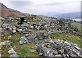
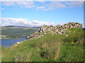
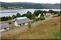
Multi-periodSite Name: Dun An Ruigh RuadhCountry: Scotland County: Highlands Type: Stone Fort or Dun
Map Ref: NH14939008
Latitude: 57.861756N Longitude: 5.121223W
Condition:
| 5 | Perfect |
| 4 | Almost Perfect |
| 3 | Reasonable but with some damage |
| 2 | Ruined but still recognisable as an ancient site |
| 1 | Pretty much destroyed, possibly visible as crop marks |
| 0 | No data. |
| -1 | Completely destroyed |
| 5 | Superb |
| 4 | Good |
| 3 | Ordinary |
| 2 | Not Good |
| 1 | Awful |
| 0 | No data. |
| 5 | Can be driven to, probably with disabled access |
| 4 | Short walk on a footpath |
| 3 | Requiring a bit more of a walk |
| 2 | A long walk |
| 1 | In the middle of nowhere, a nightmare to find |
| 0 | No data. |
| 5 | co-ordinates taken by GPS or official recorded co-ordinates |
| 4 | co-ordinates scaled from a detailed map |
| 3 | co-ordinates scaled from a bad map |
| 2 | co-ordinates of the nearest village |
| 1 | co-ordinates of the nearest town |
| 0 | no data |
Internal Links:
External Links:
I have visited· I would like to visit
Andy B has visited here
")
Excavations by MacKie in 1968 revealed a flattened circle on plan, the straighter side of which runs along the edge of the bluff. Here, the wall is thinner and less well built, lacking the intra-mural gallery visible elsewhere. The stairway to the first-floor level and part of the stair to an even higher level are discernible. The doorway in the E is checked. A scarcement is visible 4 1/2' - 5' above ground level. Within the central court are post-holes indicating a raised wooden structure resting on the scarce- ment and posts, which was later pulled down, and the dun used as an ordinary dwelling. The post-holes were filled in, cobbles laid on top of them, and a stone tank was sunk into the interior. Finds include several rotary querns, a stone pot lid, a jet counter, hammer stones, and a silver finger ring. More at Scotland's Places
You may be viewing yesterday's version of this page. To see the most up to date information please register for a free account.
Do not use the above information on other web sites or publications without permission of the contributor.
Nearby Images from Geograph Britain and Ireland:
©2020(licence)
©2010(licence)
©2016(licence)
©2021(licence)
©2014(licence)
The above images may not be of the site on this page, they are loaded from Geograph.
Please Submit an Image of this site or go out and take one for us!
Click here to see more info for this site
Nearby sites
Key: Red: member's photo, Blue: 3rd party photo, Yellow: other image, Green: no photo - please go there and take one, Grey: site destroyed
Download sites to:
KML (Google Earth)
GPX (GPS waypoints)
CSV (Garmin/Navman)
CSV (Excel)
To unlock full downloads you need to sign up as a Contributory Member. Otherwise downloads are limited to 50 sites.
Turn off the page maps and other distractions
Nearby sites listing. In the following links * = Image available
1.4km NNW 329° Dun Lagaidh* Stone Fort or Dun (NH14239135)
2.0km E 87° Allt Raon A'Chroisg Broch or Nuraghe (NH16959008)
5.3km SSW 210° Bruthach Na Garbh Choille Ancient Village or Settlement (NH120856)
7.0km W 279° Beinn Ghobhlach Standing Stone* Standing Stone (Menhir) (NH080915)
10.3km NNW 326° Isle Martin Cross Stone* Ancient Cross (NH096989)
11.3km NNW 338° Dun Canna* Stone Fort or Dun (NC11160080)
12.0km N 5° An Dun, Strath Canaird Stone Fort or Dun (NC16530196)
18.3km W 277° Stones near Mungasdale Natural Stone / Erratic / Other Natural Feature (NG9686393111)
20.6km NW 322° Achlochan Broch* Broch or Nuraghe (NC029069)
23.1km NNE 16° Glacbain* Cairn (NC2231112011)
23.5km NE 38° Cnoc Chaornaidh South-east* Chambered Cairn (NC30320793)
23.6km NE 37° Cnoc Chaornaidh North West* Chambered Cairn (NC299084)
23.6km NE 37° Cnoc Chaornaidh Central* Cairn (NC30170818)
23.7km NNE 19° Ledmore* Chambered Cairn (NC23821215)
23.8km NNE 25° Loch Borralan West* Chambered Cairn (NC2603811142)
23.8km NNE 24° Loch Borralan Crannog* Crannog (NC25741138)
23.9km NNE 26° Loch Borralan East* Chambered Cairn (NC26241118)
23.9km NNE 26° Altnacealgach* Chambered Cairn (NC2652811033)
24.5km NNE 18° Cam Loch B Chambered Cairn (NC23431314)
24.5km NNE 18° Cam Loch A Cairn (NC23501312)
26.0km NNE 20° Ledbeg River* Chambered Cairn (NC24891411)
26.3km W 280° Mellon Udrigle Hut Circle* Ancient Village or Settlement (NG891957)
26.7km NNW 339° Inverpolly Stone Fort or Dun (NC06611551)
27.1km NNW 328° Brae of Achnahaird Stone Fort or Dun (NC01701380)
28.0km SW 228° Isle Maree* Holy Well or Sacred Spring (NG93107236)
View more nearby sites and additional images


 We would like to know more about this location. Please feel free to add a brief description and any relevant information in your own language.
 Wir möchten mehr über diese Stätte erfahren. Bitte zögern Sie nicht, eine kurze Beschreibung und relevante Informationen in Deutsch hinzuzufügen.
 Nous aimerions en savoir encore un peu sur les lieux. S'il vous plaît n'hesitez pas à ajouter une courte description et tous les renseignements pertinents dans votre propre langue.
 Quisieramos informarnos un poco más de las lugares. No dude en añadir una breve descripción y otros datos relevantes en su propio idioma.