

, Aubrey Burl")
<< Our Photo Pages >> Kastell Koz - Promontory Fort / Cliff Castle in France in Bretagne:Finistère (29)
Submitted by theCaptain on Monday, 25 January 2010 Page Views: 3732
Iron Age and Later PrehistorySite Name: Kastell Koz Alternative Name: Oppidum de Castel-CozCountry: France Département: Bretagne:Finistère (29) Type: Promontory Fort / Cliff Castle
Nearest Town: Douarnenez Nearest Village: Beuzec Cap Sizun
Latitude: 48.089000N Longitude: 4.521W
Condition:
| 5 | Perfect |
| 4 | Almost Perfect |
| 3 | Reasonable but with some damage |
| 2 | Ruined but still recognisable as an ancient site |
| 1 | Pretty much destroyed, possibly visible as crop marks |
| 0 | No data. |
| -1 | Completely destroyed |
| 5 | Superb |
| 4 | Good |
| 3 | Ordinary |
| 2 | Not Good |
| 1 | Awful |
| 0 | No data. |
| 5 | Can be driven to, probably with disabled access |
| 4 | Short walk on a footpath |
| 3 | Requiring a bit more of a walk |
| 2 | A long walk |
| 1 | In the middle of nowhere, a nightmare to find |
| 0 | No data. |
| 5 | co-ordinates taken by GPS or official recorded co-ordinates |
| 4 | co-ordinates scaled from a detailed map |
| 3 | co-ordinates scaled from a bad map |
| 2 | co-ordinates of the nearest village |
| 1 | co-ordinates of the nearest town |
| 0 | no data |
Internal Links:
External Links:
I have visited· I would like to visit
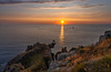
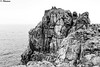
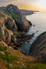
TheCaptain visited on 18th Jun 2005 - their rating: Cond: 3 Amb: 5 Access: 4 This is a superb cliff castle, made on the beautiful headland of the Pointe de Beuzec jutting north into the Baie de Duarnenez. It is defended on its southern side from the mainland with several rows of banks and ditches. The views from here are superb.
")
The views from here are superb.
You may be viewing yesterday's version of this page. To see the most up to date information please register for a free account.
")
Do not use the above information on other web sites or publications without permission of the contributor.
Nearby Images from Flickr


The above images may not be of the site on this page, but were taken nearby. They are loaded from Flickr so please click on them for image credits.
Click here to see more info for this site
Nearby sites
Click here to view sites on an interactive map of the areaKey: Red: member's photo, Blue: 3rd party photo, Yellow: other image, Green: no photo - please go there and take one, Grey: site destroyed
Download sites to:
KML (Google Earth)
GPX (GPS waypoints)
CSV (Garmin/Navman)
CSV (Excel)
To unlock full downloads you need to sign up as a Contributory Member. Otherwise downloads are limited to 50 sites.
Turn off the page maps and other distractions
Nearby sites listing. In the following links * = Image available
1.0km WSW 239° Luguenez menhir* Standing Stone (Menhir)
4.4km E 82° Vaisseau de Pierre de Saint Conogan* Standing Stone (Menhir)
4.9km SW 227° Chapelle de Lannourec stèle* Standing Stone (Menhir)
5.0km E 97° Kerbalanec Allée Couverte* Passage Grave
6.5km SW 236° Saint-Goulien stèles* Standing Stones
7.2km E 86° Lésaouvréguen menhir Standing Stone (Menhir)
8.1km WSW 252° Dolmen de Penharn* Burial Chamber or Dolmen
8.5km E 83° Menhir de Kermenhir* Standing Stone (Menhir)
8.7km S 179° Saint-Dreyel mégalithe Standing Stone (Menhir)
9.2km SW 215° St. Tugen holy well* Holy Well or Sacred Spring
9.2km SW 222° Dolmen de la Chapelle Sainte-Théodore* Burial Chamber or Dolmen
9.2km ESE 108° Dolmen de la Chapelle de Kerinec* Burial Chamber or Dolmen
9.2km ESE 107° Menhir de la Chapelle de Kerinec* Standing Stone (Menhir)
9.7km SW 223° Primelin stèle* Standing Stone (Menhir)
10.1km E 85° Tréota menhir Standing Stone (Menhir)
10.5km E 80° Menhir de Kergavan 2* Standing Stone (Menhir)
10.5km E 88° Lesconil allée couverte* Passage Grave
10.6km E 89° Dolmen de Lesconil Burial Chamber or Dolmen
10.6km E 87° Dolmen du Manoir de Treota Burial Chamber or Dolmen
10.7km E 82° Menhir de Kergavan 1 Standing Stone (Menhir)
10.8km N 354° Dolmen de Rostudel* Burial Chamber or Dolmen
11.3km N 349° Dolmen de Persig Burial Chamber or Dolmen
11.5km N 350° Alignement de Menesguen Stone Row / Alignment
11.6km N 351° Menhir dit Ar Men Vras Zalous Standing Stone (Menhir)
11.6km SW 235° Chapelle Notre-Dame de Bon Voyage cairns* Chambered Cairn
View more nearby sites and additional images


 We would like to know more about this location. Please feel free to add a brief description and any relevant information in your own language.
 Wir möchten mehr über diese Stätte erfahren. Bitte zögern Sie nicht, eine kurze Beschreibung und relevante Informationen in Deutsch hinzuzufügen.
 Nous aimerions en savoir encore un peu sur les lieux. S'il vous plaît n'hesitez pas à ajouter une courte description et tous les renseignements pertinents dans votre propre langue.
 Quisieramos informarnos un poco más de las lugares. No dude en añadir una breve descripción y otros datos relevantes en su propio idioma.