


<< Our Photo Pages >> Pendle Hill - Round Barrow(s) in England in Lancashire
Submitted by coldrum on Tuesday, 04 August 2009 Page Views: 12001
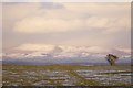
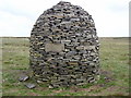
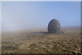
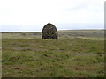
Neolithic and Bronze AgeSite Name: Pendle Hill Alternative Name: Pendle Forest History SocietyCountry: England County: Lancashire Type: Round Barrow(s)
Nearest Town: Clitheroe
Map Ref: SD789414
Latitude: 53.868377N Longitude: 2.322358W
Condition:
| 5 | Perfect |
| 4 | Almost Perfect |
| 3 | Reasonable but with some damage |
| 2 | Ruined but still recognisable as an ancient site |
| 1 | Pretty much destroyed, possibly visible as crop marks |
| 0 | No data. |
| -1 | Completely destroyed |
| 5 | Superb |
| 4 | Good |
| 3 | Ordinary |
| 2 | Not Good |
| 1 | Awful |
| 0 | No data. |
| 5 | Can be driven to, probably with disabled access |
| 4 | Short walk on a footpath |
| 3 | Requiring a bit more of a walk |
| 2 | A long walk |
| 1 | In the middle of nowhere, a nightmare to find |
| 0 | No data. |
| 5 | co-ordinates taken by GPS or official recorded co-ordinates |
| 4 | co-ordinates scaled from a detailed map |
| 3 | co-ordinates scaled from a bad map |
| 2 | co-ordinates of the nearest village |
| 1 | co-ordinates of the nearest town |
| 0 | no data |
Be the first person to rate this site - see the 'Contribute!' box in the right hand menu.
Internal Links:
External Links:
I have visited· I would like to visit
FrothNinja has visited here
")
They are teaming up with staff from Lancaster-based Oxford Archaeology North, who will provide training in research and field-surveying techniques.
But the archaeologists are leaving their excavating tools at home as the team aim to uncover secrets without digging a single hole.
They are using old records, maps and aerial photographs to identify historic sites around the villages of Barley, Newchurch and Roughlee and are calling for help from people who have ever found anything unusual in the area.
Members will pinpoint sites and use the latest technology to make a detailed record of finds.
Work has already started on the legendary hill, where it is believed people have lived since the Stone Age, as part of The Landscape Stories project.
Only a limited amount of physical investigation has been carried out in the and the information collected by the group will be a valuable addition to Lancashire’s Historic Environment Record, the definitive record of all the historic monuments.
Joan Parsons, chairman of Pendle Forest History Group, said the area was “littered” with possible finds.
She added: “It’s very exciting. In some of the old leaflets and booklets there are things that people have seen.
“From our house in Spen Brook you can see where a very big stone circle has been moved which has previously been recorded on the old maps.
“We’re hoping to look at things like burial grounds.
“Flint arrowheads, stone axeheads, bronze barbs for spears have been found and recorded in little brochures but not further afield and it has just got lost. English Heritage do maps of interest but it is a bit bare around here.”
The work is part of a wider project being co-ordinated by Pendle Area Of Outstanding Natural Beauty team.
Source: Lancashire Telegraph
You may be viewing yesterday's version of this page. To see the most up to date information please register for a free account.
")
")
Do not use the above information on other web sites or publications without permission of the contributor.
Nearby Images from Geograph Britain and Ireland:
©2007(licence)
©2009(licence)
©2010(licence)
©2009(licence)
©2014(licence)
The above images may not be of the site on this page, they are loaded from Geograph.
Please Submit an Image of this site or go out and take one for us!
Click here to see more info for this site
Nearby sites
Key: Red: member's photo, Blue: 3rd party photo, Yellow: other image, Green: no photo - please go there and take one, Grey: site destroyed
Download sites to:
KML (Google Earth)
GPX (GPS waypoints)
CSV (Garmin/Navman)
CSV (Excel)
To unlock full downloads you need to sign up as a Contributory Member. Otherwise downloads are limited to 50 sites.
Turn off the page maps and other distractions
Nearby sites listing. In the following links * = Image available
1.9km SSW 198° Badger Wells Cairn Cairn (SD783396)
2.1km NNW 332° Worsaw Hill Burial Mound* Round Barrow(s) (SD77934323)
2.2km NE 50° Pendle Hill Ringwork and Barrow Hillfort (SD806428)
2.3km SSW 205° Devil's Apronful (Pendle Hill) Cairn (SD779393)
2.6km SSW 204° Lower Apronful of Stones (Pendle Hill) Cairn (SD778390)
3.0km NNW 346° Great Stone (Downham)* Standing Stone (Menhir) (SD782443)
3.3km SSW 208° Solar Wheel Year Stone (Sabden) Rock Art (SD77323846)
3.5km SSW 209° Coffin Stone (Sabden) Standing Stone (Menhir) (SD77173830)
4.0km ESE 119° Jinny Well* Holy Well or Sacred Spring (SD8238039461)
4.3km SE 129° Newchurch-in-Pendle* Stone Circle (SD822387)
4.5km SE 131° St Chad's Well, Tinedale Farm, Spen Brook.* Holy Well or Sacred Spring (SD82253845)
4.6km SW 219° Jeppe Knave's Grave* Cairn (SD75993782)
5.4km WNW 283° Peg o'Nell's Well* Holy Well or Sacred Spring (SD73684266)
5.5km SSW 193° Simon's Cross (Padiham)* Ancient Cross (SD77603609)
5.9km E 87° Aedmer's Mound (Admergill)* Artificial Mound (SD8482941718)
5.9km SW 226° Wisa's Well (Wiswell)* Holy Well or Sacred Spring (SD746373)
6.3km NE 52° Middop Earthworks* Misc. Earthwork (SD839452)
6.5km E 86° Blacko Cross (Blacko Hill) Ancient Cross (SD85414187)
6.6km WNW 290° Pinder Hill (Waddington) Cairn (SD72724370)
6.7km E 92° Cock Hill Standing Stone* Standing Stone (Menhir) (SD85624110)
6.8km SW 230° High Wall Well (Bramley Meade)* Holy Well or Sacred Spring (SD73663702)
7.3km SW 216° Portfield* Hillfort (SD7458135499)
7.6km N 8° Fooden Spring Holy Well or Sacred Spring (SD7993548892)
7.7km SW 227° Whalley Crosses* Ancient Cross (SD73263616)
7.7km SW 226° St Mary and All Saints Church (Whalley)* Sculptured Stone (SD733361)
View more nearby sites and additional images


 We would like to know more about this location. Please feel free to add a brief description and any relevant information in your own language.
 Wir möchten mehr über diese Stätte erfahren. Bitte zögern Sie nicht, eine kurze Beschreibung und relevante Informationen in Deutsch hinzuzufügen.
 Nous aimerions en savoir encore un peu sur les lieux. S'il vous plaît n'hesitez pas à ajouter une courte description et tous les renseignements pertinents dans votre propre langue.
 Quisieramos informarnos un poco más de las lugares. No dude en añadir una breve descripción y otros datos relevantes en su propio idioma.