


<< Our Photo Pages >> Limantepe - Ancient Village or Settlement in Turkey
Submitted by davidmorgan on Tuesday, 23 June 2015 Page Views: 11709
Multi-periodSite Name: Limantepe Alternative Name: Liman Tepe, KlazomenaiCountry: Turkey Type: Ancient Village or Settlement
Nearest Town: İzmir Nearest Village: Urla
Latitude: 38.362560N Longitude: 26.775670E
Condition:
| 5 | Perfect |
| 4 | Almost Perfect |
| 3 | Reasonable but with some damage |
| 2 | Ruined but still recognisable as an ancient site |
| 1 | Pretty much destroyed, possibly visible as crop marks |
| 0 | No data. |
| -1 | Completely destroyed |
| 5 | Superb |
| 4 | Good |
| 3 | Ordinary |
| 2 | Not Good |
| 1 | Awful |
| 0 | No data. |
| 5 | Can be driven to, probably with disabled access |
| 4 | Short walk on a footpath |
| 3 | Requiring a bit more of a walk |
| 2 | A long walk |
| 1 | In the middle of nowhere, a nightmare to find |
| 0 | No data. |
| 5 | co-ordinates taken by GPS or official recorded co-ordinates |
| 4 | co-ordinates scaled from a detailed map |
| 3 | co-ordinates scaled from a bad map |
| 2 | co-ordinates of the nearest village |
| 1 | co-ordinates of the nearest town |
| 0 | no data |
Internal Links:
External Links:
I have visited· I would like to visit
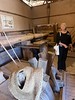
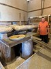
davidmorgan visited on 24th Sep 2018 There were archaeologists working on this site. Not a lot to see.
")
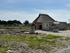
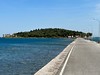
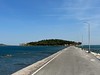
A harbour settlement inhabited starting from 6000 years ago and apparently equipped with a fortification wall partially submerged in the sea along the shore significantly transformed in time, Limantepe is one of the oldest known artificial harbors in the Aegean Sea.
Discovered by Ekrem Akurgal in 1950, its exploration is being pursued simultaneously on land and underwater since 1979 by an international team and many of the artifacts discovered are currently on display in İzmir Archaeology Museum. It is very close but separate from the site of Klazomenai, inhabited as of the Iron Age and which itself had changed location several times during its history in the same area between the mainland and Karantina Island across its coastline.
Read more on this site at Wikipedia and more images on Flickr.
Note: Underwater archaeology research center opens in İzmir, and more Neolithic marine archaeology news in the comments
You may be viewing yesterday's version of this page. To see the most up to date information please register for a free account.
")
")
")
Do not use the above information on other web sites or publications without permission of the contributor.
Nearby Images from Flickr

The above images may not be of the site on this page, but were taken nearby. They are loaded from Flickr so please click on them for image credits.
Click here to see more info for this site
Nearby sites
Click here to view sites on an interactive map of the areaKey: Red: member's photo, Blue: 3rd party photo, Yellow: other image, Green: no photo - please go there and take one, Grey: site destroyed
Download sites to:
KML (Google Earth)
GPX (GPS waypoints)
CSV (Garmin/Navman)
CSV (Excel)
To unlock full downloads you need to sign up as a Contributory Member. Otherwise downloads are limited to 50 sites.
Turn off the page maps and other distractions
Nearby sites listing. In the following links * = Image available
477m WSW 254° Klazomenai* Ancient Village or Settlement
20.6km S 178° Teos* Ancient Village or Settlement
21.0km S 177° Teos cistern* Ancient Village or Settlement
21.3km S 176° Teos harbour* Ancient Village or Settlement
25.8km W 275° Erythrae* Ancient Village or Settlement
31.2km E 79° Izmir Archaeological Museum* Museum
32.2km NNE 26° Panaztepe Ancient Village or Settlement
32.3km ENE 79° Smyrna Agora* Ancient Village or Settlement
33.0km N 0° Seytan Hamami Rock Cut Tomb
33.4km N 7° Tas Kule* Rock Cut Tomb
34.2km N 357° Phokaia* Ancient Village or Settlement
35.8km SSE 152° Lebedos* Ancient Village or Settlement
36.2km ENE 72° Bayrakli Ancient Village or Settlement
39.2km ENE 76° Yassitepe* Ancient Village or Settlement
39.2km ENE 77° Yesilova Tumulus* Round Barrow(s)
40.5km NNE 33° Larissa (Aeolis) Ancient Village or Settlement
41.3km W 264° Cesme-Baglararasi Ancient Village or Settlement
42.6km SE 131° Kolophon Ancient Village or Settlement
42.9km NE 39° Neonteikhos* Ancient Village or Settlement
46.3km NNE 17° Kyme* Ancient Village or Settlement
54.0km SE 137° Claros Temple of Apollo* Ancient Village or Settlement
54.8km ESE 119° Metropolis* Ancient Village or Settlement
55.4km SE 138° Notion* Ancient Village or Settlement
59.3km E 89° Karabel Rock Relief* Carving
63.3km NE 35° Aigai.* Ancient Village or Settlement
View more nearby sites and additional images


 We would like to know more about this location. Please feel free to add a brief description and any relevant information in your own language.
 Wir möchten mehr über diese Stätte erfahren. Bitte zögern Sie nicht, eine kurze Beschreibung und relevante Informationen in Deutsch hinzuzufügen.
 Nous aimerions en savoir encore un peu sur les lieux. S'il vous plaît n'hesitez pas à ajouter une courte description et tous les renseignements pertinents dans votre propre langue.
 Quisieramos informarnos un poco más de las lugares. No dude en añadir una breve descripción y otros datos relevantes en su propio idioma.