 with our Megalithic Portal iPhone app")

<< Image Pages >> Gohlau Steingrab 3 - Chambered Tomb in Germany in Lower Saxony, Bremen
Submitted by Martin_L on Saturday, 07 March 2009 Page Views: 2442
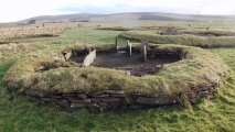
Neolithic and Bronze AgeSite Name: Gohlau Steingrab 3 Alternative Name: Sprockhoff 731Country: Germany Land: Lower Saxony, Bremen Type: Chambered Tomb
Nearest Town: Lüchow Nearest Village: Gohlau
Latitude: 52.999900N Longitude: 10.906500E
Condition:
| 5 | Perfect |
| 4 | Almost Perfect |
| 3 | Reasonable but with some damage |
| 2 | Ruined but still recognisable as an ancient site |
| 1 | Pretty much destroyed, possibly visible as crop marks |
| 0 | No data. |
| -1 | Completely destroyed |
| 5 | Superb |
| 4 | Good |
| 3 | Ordinary |
| 2 | Not Good |
| 1 | Awful |
| 0 | No data. |
| 5 | Can be driven to, probably with disabled access |
| 4 | Short walk on a footpath |
| 3 | Requiring a bit more of a walk |
| 2 | A long walk |
| 1 | In the middle of nowhere, a nightmare to find |
| 0 | No data. |
| 5 | co-ordinates taken by GPS or official recorded co-ordinates |
| 4 | co-ordinates scaled from a detailed map |
| 3 | co-ordinates scaled from a bad map |
| 2 | co-ordinates of the nearest village |
| 1 | co-ordinates of the nearest town |
| 0 | no data |
Internal Links:
External Links:
")
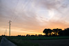
Within an oval barrow one orthostat of the chamber still is in situ, twelve other large stones are scattered around.
Reference:
Schroller, Schwieger in: Körner, G. (Ed.), Sprockhoff, E. Atlas der Megalithgräber Deutschlands, Niedersachsen-Westfalen, p. 52, Habelt, Bonn 1975
You may be viewing yesterday's version of this page. To see the most up to date information please register for a free account.
Do not use the above information on other web sites or publications without permission of the contributor.
Nearby Images from Flickr

The above images may not be of the site on this page, but were taken nearby. They are loaded from Flickr so please click on them for image credits.
Click here to see more info for this site
Nearby sites
Click here to view sites on an interactive map of the areaKey: Red: member's photo, Blue: 3rd party photo, Yellow: other image, Green: no photo - please go there and take one, Grey: site destroyed
Download sites to:
KML (Google Earth)
GPX (GPS waypoints)
CSV (Garmin/Navman)
CSV (Excel)
To unlock full downloads you need to sign up as a Contributory Member. Otherwise downloads are limited to 50 sites.
Turn off the page maps and other distractions
Nearby sites listing. In the following links * = Image available
769m S 176° Dickfeitzen Steingrab* Chambered Tomb
1.2km N 353° Gohlau Steingrab 2* Chambered Tomb
2.1km S 176° Braudel Steingrab 1* Chambered Tomb
2.7km SSW 195° Braudel Steingrab 2* Chambered Tomb
2.8km SSW 196° Braudel Steingrab 3* Chambered Tomb
2.9km NNE 20° Gohlau Steingrab 1* Chambered Tomb
3.4km NNE 24° Wittfeitzen Steingrab* Chambered Tomb
4.0km S 180° Reddereitz Steingrab 3 Long Barrow
4.3km S 181° Reddereitz Steingrab 1* Chambered Tomb
4.4km S 179° Reddereitz Steingrab 2* Long Barrow
4.6km S 174° Reddereitz Findlingspark* Natural Stone / Erratic / Other Natural Feature
6.4km NW 315° Brautsteine* Natural Stone / Erratic / Other Natural Feature
13.4km NNE 13° Opferstein Plumbohm Natural Stone / Erratic / Other Natural Feature
13.7km W 280° Dörmte Grab 1* Long Barrow
14.9km WNW 300° Weste Grab 1* Long Barrow
15.1km W 280° Oetzen Grab 10* Long Barrow
15.1km NW 305° Brockhimbergen Grab 2* Long Barrow
15.1km NW 305° Brockhimbergen Grab 1* Long Barrow
15.3km NW 309° Brockhimbergen Grab 3* Long Barrow
15.6km WNW 291° Weste Grab 2* Long Barrow
15.6km WSW 254° Hanstedt Grab 1* Long Barrow
16.1km W 266° Riestedt Grab 2* Long Barrow
16.2km W 267° Riestedt Grab 1* Chambered Tomb
16.2km WSW 244° Kahlstorf Langbett* Long Barrow
16.3km W 279° Oetzen Grab 4* Long Barrow
View more nearby sites and additional images


 We would like to know more about this location. Please feel free to add a brief description and any relevant information in your own language.
 Wir möchten mehr über diese Stätte erfahren. Bitte zögern Sie nicht, eine kurze Beschreibung und relevante Informationen in Deutsch hinzuzufügen.
 Nous aimerions en savoir encore un peu sur les lieux. S'il vous plaît n'hesitez pas à ajouter une courte description et tous les renseignements pertinents dans votre propre langue.
 Quisieramos informarnos un poco más de las lugares. No dude en añadir una breve descripción y otros datos relevantes en su propio idioma.