


<< Text Pages >> Pendrathen beach - Ancient Village or Settlement in England in Isles of Scilly
Submitted by coldrum on Tuesday, 27 January 2009 Page Views: 4565
Multi-periodSite Name: Pendrathen beachCountry: England County: Isles of Scilly Type: Ancient Village or Settlement
Map Ref: SV914127
Latitude: 49.934609N Longitude: 6.302097W
Condition:
| 5 | Perfect |
| 4 | Almost Perfect |
| 3 | Reasonable but with some damage |
| 2 | Ruined but still recognisable as an ancient site |
| 1 | Pretty much destroyed, possibly visible as crop marks |
| 0 | No data. |
| -1 | Completely destroyed |
| 5 | Superb |
| 4 | Good |
| 3 | Ordinary |
| 2 | Not Good |
| 1 | Awful |
| 0 | No data. |
| 5 | Can be driven to, probably with disabled access |
| 4 | Short walk on a footpath |
| 3 | Requiring a bit more of a walk |
| 2 | A long walk |
| 1 | In the middle of nowhere, a nightmare to find |
| 0 | No data. |
| 5 | co-ordinates taken by GPS or official recorded co-ordinates |
| 4 | co-ordinates scaled from a detailed map |
| 3 | co-ordinates scaled from a bad map |
| 2 | co-ordinates of the nearest village |
| 1 | co-ordinates of the nearest town |
| 0 | no data |
Be the first person to rate this site - see the 'Contribute!' box in the right hand menu.
Internal Links:
External Links:
Ancient Village or Settlement in Scilly Isles
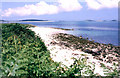
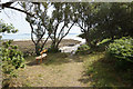
A prehistoric hut circle settlement located in the inter-tidal zone on Pendrathen beach.
Pastscape record: www.pastscape.org.uk
You may be viewing yesterday's version of this page. To see the most up to date information please register for a free account.
Do not use the above information on other web sites or publications without permission of the contributor.
Nearby Images from Geograph Britain and Ireland:
©2018(licence)
©2018(licence)
©2016(licence)
©2008(licence)
©2018(licence)
The above images may not be of the site on this page, they are loaded from Geograph.
Please Submit an Image of this site or go out and take one for us!
Click here to see more info for this site
Nearby sites
Key: Red: member's photo, Blue: 3rd party photo, Yellow: other image, Green: no photo - please go there and take one, Grey: site destroyed
Download sites to:
KML (Google Earth)
GPX (GPS waypoints)
CSV (Garmin/Navman)
CSV (Excel)
To unlock full downloads you need to sign up as a Contributory Member. Otherwise downloads are limited to 50 sites.
Turn off the page maps and other distractions
Nearby sites listing. In the following links * = Image available
125m ENE 58° Porthloo Bronze Age Cairn Cairn (SV91511276)
156m NE 47° Porthloo Barrow Round Barrow(s) (SV91521280)
223m NNE 23° Bar Point Ancient Village or Settlement (SV915129)
300m S 177° NOT SET
302m S 184° The Long Rock* Standing Stone (Menhir) (SV91361240)
348m WSW 239° Halangy Menhir* Standing Stone (Menhir) (SV91091254)
411m ENE 73° Little Porth Ancient Village or Settlement (SV918128)
420m W 261° Halangy Point Carn Cairn (SV90981266)
533m SW 228° Halangy Down* Ancient Village or Settlement (SV90981237)
533m E 92° Helvear Down* Cairn (SV9193312655)
539m SW 233° Halangy Lower* Chambered Cairn (SV90951240)
571m SW 222° Bant's Carn* Burial Chamber or Dolmen (SV90991230)
650m SW 234° Halangy Porth Cist* Cist (SV90851235)
697m E 87° Innisidgen Hill Misc. Earthwork (SV921127)
708m E 85° Innisidgen Lower* Burial Chamber or Dolmen (SV92111272)
779m E 90° Innisidgen Upper* Burial Chamber or Dolmen (SV92181265)
891m ESE 113° Helvear Farm Cairn (SV922123)
926m SSW 214° Carn Morval Down (2)* Cairn (SV90841196)
954m SW 219° Carn Morval Down (1)* Chambered Tomb (SV90761199)
964m SSE 167° Town Lane (St Mary's) Cist (SV91571175)
981m ESE 111° Helvear Hill* Chambered Cairn (SV923123)
1.2km SE 146° Maypole Chambered Tomb (SV920117)
1.2km SW 220° Carn Morval Down (3) Misc. Earthwork (SV90581182)
1.3km SSE 160° Holy Vale Longstone* Standing Stone (Menhir) (SV91771147)
1.3km ESE 113° Toll's Hill (2) Misc. Earthwork (SV926121)
View more nearby sites and additional images


 We would like to know more about this location. Please feel free to add a brief description and any relevant information in your own language.
 Wir möchten mehr über diese Stätte erfahren. Bitte zögern Sie nicht, eine kurze Beschreibung und relevante Informationen in Deutsch hinzuzufügen.
 Nous aimerions en savoir encore un peu sur les lieux. S'il vous plaît n'hesitez pas à ajouter une courte description et tous les renseignements pertinents dans votre propre langue.
 Quisieramos informarnos un poco más de las lugares. No dude en añadir una breve descripción y otros datos relevantes en su propio idioma.