

<< Our Photo Pages >> Treveglos, Zennor - Stone Row / Alignment in England in Cornwall
Submitted by vicky on Tuesday, 03 July 2007 Page Views: 10151
Neolithic and Bronze AgeSite Name: Treveglos, ZennorCountry: England County: Cornwall Type: Stone Row / Alignment
Nearest Town: St Ives Nearest Village: Zennor
Map Ref: SW45393887 Landranger Map Number: 203
Latitude: 50.194974N Longitude: 5.568782W
Condition:
| 5 | Perfect |
| 4 | Almost Perfect |
| 3 | Reasonable but with some damage |
| 2 | Ruined but still recognisable as an ancient site |
| 1 | Pretty much destroyed, possibly visible as crop marks |
| 0 | No data. |
| -1 | Completely destroyed |
| 5 | Superb |
| 4 | Good |
| 3 | Ordinary |
| 2 | Not Good |
| 1 | Awful |
| 0 | No data. |
| 5 | Can be driven to, probably with disabled access |
| 4 | Short walk on a footpath |
| 3 | Requiring a bit more of a walk |
| 2 | A long walk |
| 1 | In the middle of nowhere, a nightmare to find |
| 0 | No data. |
| 5 | co-ordinates taken by GPS or official recorded co-ordinates |
| 4 | co-ordinates scaled from a detailed map |
| 3 | co-ordinates scaled from a bad map |
| 2 | co-ordinates of the nearest village |
| 1 | co-ordinates of the nearest town |
| 0 | no data |
Internal Links:
External Links:
I have visited· I would like to visit
TheCaptain visited on 15th Jun 2023 - their rating: Cond: 3 Amb: 3 Access: 3 I found the large gatepost in the corner of the field, but nothing obvious nearby. The fields and walls here are full of large stones, and what is a standing stone, and what is a natural feature is very hard to tell. Not helped by a lot of growth around the field boundaries. I'm certainly not convinced of a row. Perhaps I was looking in all the wrong fields
lucasn visited on 8th Sep 2018 - their rating: Cond: 3 Amb: 4 Access: 3
Bladup have visited here
Average ratings for this site from all visit loggers: Condition: 3 Ambience: 3.5 Access: 3
")
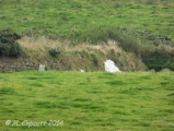
Of the four stones in the row, the one to the east now forms an eight foot tall gatepost, the two in the middle are fallen and broken in a field, and the fourth stands in a field boundary hedge.
Have you visited this site? Please contribute a description or any thoughts by adding a comment.
You may be viewing yesterday's version of this page. To see the most up to date information please register for a free account.
")
")
")
")
")
")
")
")
")
")
")
")
")
")
")
")
")
Do not use the above information on other web sites or publications without permission of the contributor.
Click here to see more info for this site
Nearby sites
Key: Red: member's photo, Blue: 3rd party photo, Yellow: other image, Green: no photo - please go there and take one, Grey: site destroyed
Download sites to:
KML (Google Earth)
GPX (GPS waypoints)
CSV (Garmin/Navman)
CSV (Excel)
To unlock full downloads you need to sign up as a Contributory Member. Otherwise downloads are limited to 50 sites.
![]()
Turn off the page maps and other distractions
Nearby sites listing. In the following links * = Image available
90m S 184° Giant's Rock, Zennor* Natural Stone / Erratic / Other Natural Feature (SW45383878)
347m SSE 166° Zennor Churchyard Crosses* Ancient Cross (SW45463853)
376m SSE 167° Trevega Cross* Ancient Cross (SW45463850)
424m SE 134° Treveglos Menhir* Standing Stone (Menhir) (SW4568238561)
844m SE 138° Venton Zennor* Holy Well or Sacred Spring (SW4592538215)
1.2km ESE 123° Zennor Hill propped stone* Natural Stone / Erratic / Other Natural Feature (SW4639638146)
1.3km SE 125° Zennor Hill and Carn Zennor* Rock Outcrop (SW464381)
1.3km S 177° Kerrowe Farm Tumulus* Round Barrow(s) (SW454376)
1.3km SSE 158° Trewey Hill* Cairn (SW45823767)
1.3km ESE 120° Lower Carne Settlement* Ancient Village or Settlement (SW4650738144)
1.4km WSW 243° Poniou Settlement* Ancient Village or Settlement (SW44143830)
1.4km SW 222° Boswednack Menhir* Standing Stone (Menhir) (SW4438937874)
1.5km SSW 202° Pennance Entrance Grave* Chambered Tomb (SW44763753)
1.5km S 188° Kerrowe Hut Circle* Ancient Village or Settlement (SW451374)
1.6km SE 127° Zennor settlement* Ancient Village or Settlement (SW46583787)
1.6km S 183° Kerrowe Menhir* Standing Stone (Menhir) (SW45233732)
1.7km SE 130° Foage Iron Age/Romano British Courtyard House 1 Ancient Village or Settlement (SW46643770)
1.7km ESE 117° Zennor Quoit* Portal Tomb (SW46883802)
1.8km ESE 107° Sperris Quoit* Burial Chamber or Dolmen (SW47093826)
1.8km E 87° Wicca Cists* Cist (SW47203887)
1.8km ESE 123° Zennor tumuli* Barrow Cemetery (SW469378)
2.0km E 101° Sperris Croft* Ancient Village or Settlement (SW473384)
2.0km SE 127° Foage Cairn* Cairn (SW469376)
2.1km WSW 250° Chapel Jane* Holy Well or Sacred Spring (SW43413824)
2.1km SSW 199° Gear Common* Ancient Village or Settlement (SW446369)
View more nearby sites and additional images


 We would like to know more about this location. Please feel free to add a brief description and any relevant information in your own language.
 Wir möchten mehr über diese Stätte erfahren. Bitte zögern Sie nicht, eine kurze Beschreibung und relevante Informationen in Deutsch hinzuzufügen.
 Nous aimerions en savoir encore un peu sur les lieux. S'il vous plaît n'hesitez pas à ajouter une courte description et tous les renseignements pertinents dans votre propre langue.
 Quisieramos informarnos un poco más de las lugares. No dude en añadir una breve descripción y otros datos relevantes en su propio idioma.