

<< Our Photo Pages >> Bullstones - Stone Circle in England in Cheshire
Submitted by vicky on Sunday, 26 May 2002 Page Views: 13553
Neolithic and Bronze AgeSite Name: Bullstones Alternative Name: BullstrangCountry: England County: Cheshire Type: Stone Circle
Nearest Town: Macclesfield Nearest Village: Wincle
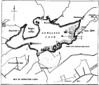
Map Ref: SJ9556867627
Latitude: 53.205693N Longitude: 2.067811W
Condition:
| 5 | Perfect |
| 4 | Almost Perfect |
| 3 | Reasonable but with some damage |
| 2 | Ruined but still recognisable as an ancient site |
| 1 | Pretty much destroyed, possibly visible as crop marks |
| 0 | No data. |
| -1 | Completely destroyed |
| 5 | Superb |
| 4 | Good |
| 3 | Ordinary |
| 2 | Not Good |
| 1 | Awful |
| 0 | No data. |
| 5 | Can be driven to, probably with disabled access |
| 4 | Short walk on a footpath |
| 3 | Requiring a bit more of a walk |
| 2 | A long walk |
| 1 | In the middle of nowhere, a nightmare to find |
| 0 | No data. |
| 5 | co-ordinates taken by GPS or official recorded co-ordinates |
| 4 | co-ordinates scaled from a detailed map |
| 3 | co-ordinates scaled from a bad map |
| 2 | co-ordinates of the nearest village |
| 1 | co-ordinates of the nearest town |
| 0 | no data |
Internal Links:
External Links:
I have visited· I would like to visit
Postman SolarMegalith SumDoood would like to visit
BrownEdger visited on 21st Aug 2011 - their rating: Cond: 3 Amb: 4 Access: 4
")
The view to the north, the east and the south is stunning. This takes in sweeping moorland and the summits of Shining Tor and Shutlingsloe to the north-east and the outcrop of The Roaches and Hen Cloud to the south-east.
According to the Cheshire County Sites and Monuments Record, The Bullstones is a classed as a barrow and as far as the Victoria County History is concerned its stones are 'obscured by vegetation'. However this is not the case at all. The Bullstones is a spectacular monument in a spectacular setting, and quite possibly one of the most important and unusual monuments in the East Cheshire area, after the Bridestones
The Bullstones, or Bullstrang as it is sometimes known, first came to the attention of Dr John Dow Sainter in the 1870s. The following extract was published his Scientific Rambles Round Macclesfield in 1878:
‘A short time ago, in a field close to the Cross, an ancient burial was investigated by myself and others. The interment proved to be that of a child or young person, and it was similar to that which had been found at Langley [see page..]. The urn, which was also of Celtic type, had been inverted, and among the burnt bones was found a calcinated flint knife and a flint arrowhead.’
Interestingly an urn, reputedly from The Bullstones, resides in the basement of the Congleton Chronicle's offices awaiting re-homing in a local museum, should Congleton ever get one.
However, it was not the burial itself that was most interesting, but the setting in which it was placed:
‘The circumstances connected with this burial were rather peculiar. It lay about three feet below the surface, and was surrounded by a stone circle twenty feet in diameter, with apparently a headstone, more or less mutilated, four feet in height and the same in breadth, placed not in the centre of the circle, but between two and three feet to one side of it, northwards. Directly opposite the headstone, the circle was entered northward by a short avenue of stones; a line of stones also ran up to the circle in an oblique curve from each corner stone at the entrance to the avenue, leaving a small semi-triangular space on both sides of sufficient dimensions to accommodate four or five persons standing upright in each’.
Sainter and a team from The Macclesfield Scientific Society did investigate these triangles but ‘upon a trial being made with a spade no burial was found in either of them.’
The site survives today more or less as Sainter described it. The most striking feature is a central standing stone which dominates the monument. It is a square looking monolith measuring 1.40m wide, 0.70m deep and 1.10m tall. Its 'flat' top contains a bowl-shaped depression formed along the stone's natural bedding, similar to the weathering 'bowls' found on many standing stones found in this region. This 'headstone' sits in a rough oval of cobble-sized stones (overall dimensions 2.80m by 2.50m including the 'headstone').
Surrounding the stone is an incomplete outer ellipse of rounded cobble to small boulder-sized stones with a diameter of 7.90m x 8.50m which appears to mark the perimeter of a small platform. Parts of this ring are barely visible and can be followed or inferred through the encroaching grass. The entrance avenue, as described by Sainter, is difficult to make out as a mass of small boulders is found today.
Being rectangular, the ‘headstone’ has a number of 'faces' that could hold alignments. The long axis of the stone appears to be orientated in the direction of Roach End (the northern tip of The Roaches outcrop). The sight line takes the eye across the Dane valley, over Back Forest (where Lud's Church gorge is situated) and on to the north end of the millstone grit ridge.
The north-eastern long plane is orientated in the direction of Cessbank Common, past the characteristic summit of Shutlingsloe to the smooth featureless ridge of Shining Tor (the highest peak in the area). While the south-western face of the stone points to the unimpressive flank of an adjacent hillock with the southerly end of Wincle Minn being visible.
So the question is, what exactly is The Bullstones? We have classed it here as a stone circle, because on the face of it that is what it is - ‘a circle of stones’. As mentioned previously the Cheshire County Sites and Monuments Record describes it as a barrow because of the burial. Dr Sainter also postulated this when he suggested that the circle and standing stone may have been enclosed in a ‘tumulus ten or twelve feet in height, with the circle of stones placed round its base’. However, just because a site has a burial there, it does not make it a burial monument. There are many examples of burials found at stone circles which were used as ritual monuments by the living. For example, at Doll Tor in the Peak District, burials and accompanying urns were found at the base of several of the standing stones, while at Arbor Low an inhumation was found close to the central cove.
The Bullstones has many similarities with the centre-stone circles of south-west Scotland, the best example being Glenquickan near Kirkcudbright. Reading Burl’s description of this site one gets the feeling of deja vu. It ‘is composed of twenty-nine very low, closely set stones in an ellipse...’with an ‘apparent gap in the ring at the south-west filled by a stone whose tip just shows above ground. The interior of the ring is tightly laid with small stones like cobbling’. This description continues ‘At the middle of the circle is an immense upright pillar...’
In his 2000 volume Burl expands his description and explanation of centre-stone circles, which are also found in Shropshire, Wiltshire, south-west Ireland and Cornwall. He states ‘circles with centre stones appear to be late and frequently have a cremation deposit at the foot of the centre stone’ and that ‘the circles are composed of unobtrusive, rounded stones whereas the interior pillar is distinctly bigger.’ He adds ‘such monuments can never have been conspicuous and were probably for local ceremonies’.
As an interesting aside, not far from Glenquickan are located a number of Neolithic Clyde cairns with their characteristic semi-circular forecourts and horned cairns. Ten kilometres south-west of The Bullstones lie The Bridestones, the remians of a ruined long cairn with close affinities to these Clyde cairns. Could this be more than just coincidence?
The site undoubtedly has more to uncover and may yet defy current classification theories, but following conversations with John Barnatt of the Peak District National Park Authority, we may be a little closer to revealing the mystery. He describes the Bullstones as ‘a truly cracking site’ which ‘does not fit with our normative typologies’. He believes it has affinities with the platform cairns found in areas such as Dartmoor and Bodmin Moor as well as the centre stone rings in South-west Scotland. Perhaps if attempts to excavate the site in 1984 had not been abandoned due to the landowner changing his mind, we may have had the answer
Viewing:
From the A54 Congleton to Buxton Road (Axe Edge), heading towards Buxton, turn left onto the minor road just after The Fourways Motel in Wincle (GR: SJ953672). Follow this lane for approximately 700m until you come to an informal lay-by opposite the junction with Withenshaw Lane. Park here and take the southern most footpath across the fields (not the metalled road). After crossing two stiles, the centre stone will be visible on the horizon.
References
Cheshire County Sites and Monuments Record
G. Rowley “Macclesfield in Prehistory” (1982)
Dr J.D.Sainter. “The Jottings of Some Geological, Archaeological, Botanical, Ornithological, and Zoological Rambles Round Macclesfield”, Swinnerton and Brown Printers, Macclesfield (1878)
D.M.Longley “Prehistory” in C.R.Elrington (ed) “The Victoria History of the County of Chester, volume 1, Oxford University Press (1987)
A. Burl “The Stone Circles of Britain, Ireland and Brittany”, Yale University Press (2000)
Note: A talk from Vicky our ex-editor: Prehistoric stone circles around Macclesfield, Sun 21st July
You may be viewing yesterday's version of this page. To see the most up to date information please register for a free account.
")
")
")
")
")
")
")
")
")
")
")
")
")
")
")
")
")
")
")
")
")
")
")
")
These are just the first 25 photos of Bullstones. If you log in with a free user account you will be able to see our entire collection.
Do not use the above information on other web sites or publications without permission of the contributor.
Click here to see more info for this site
Nearby sites
Key: Red: member's photo, Blue: 3rd party photo, Yellow: other image, Green: no photo - please go there and take one, Grey: site destroyed
Download sites to:
KML (Google Earth)
GPX (GPS waypoints)
CSV (Garmin/Navman)
CSV (Excel)
To unlock full downloads you need to sign up as a Contributory Member. Otherwise downloads are limited to 50 sites.
Turn off the page maps and other distractions
Nearby sites listing. In the following links * = Image available
237m SSW 197° Longgutter* Round Barrow(s) (SJ955674)
431m WSW 238° Clulow Cross* Round Barrow(s) (SJ952674)
526m NNE 26° Cessbank Common* Round Barrow(s) (SJ958681)
1.6km N 2° The Plague Stone* Ancient Cross (SJ9561269221)
1.7km SE 130° Allgreave* Standing Stone (Menhir) (SJ969665)
2.1km SW 228° Bosley Minn 4 & 5* Standing Stones (SJ940662)
2.2km SSE 158° Bartomley Farm* Long Barrow (SJ964656)
2.3km SW 224° Bosley Minn 2 & 3* Standing Stones (SJ940660)
2.4km SW 223° Bosley Minn 1* Standing Stone (Menhir) (SJ93886585)
3.7km ESE 123° Lud's Church* Natural Stone / Erratic / Other Natural Feature (SJ987656)
3.9km N 353° High Low* Round Barrow(s) (SJ951715)
4.0km N 359° Higher Ridgegate* Standing Stone (Menhir) (SJ9550671636)
4.1km WNW 299° Gawsworth henge* Henge (SJ920696)
4.1km WNW 303° Broad Oak Farm* Round Barrow(s) (SJ921699)
4.1km N 349° Langley Conical mound* Round Barrow(s) (SJ948717)
4.3km N 356° Teggs Nose reservoir* Round Barrow(s) (SJ953719)
4.3km NNE 30° Macclesfield Forest Ancient Cross (SJ97767136)
4.5km WNW 296° Woodhouse End* Round Barrow(s) (SJ915696)
4.5km NNE 20° Toot Hill Warilow* Round Barrow(s) (SJ971719)
4.6km NNE 19° Toot Hill* Ancient Village or Settlement (SJ971720)
4.7km ESE 106° Roaches Stone carving* Carving (SK00076637)
4.7km S 181° Heaton Low* Round Barrow(s) (SJ955629)
4.8km NNE 24° Rains Low* Round Barrow(s) (SJ975720)
4.8km NW 320° Sutton Hall* Round Barrow(s) (SJ925713)
5.0km NNE 17° Charity Lane I* Round Barrow(s) (SJ970724)
View more nearby sites and additional images


 We would like to know more about this location. Please feel free to add a brief description and any relevant information in your own language.
 Wir möchten mehr über diese Stätte erfahren. Bitte zögern Sie nicht, eine kurze Beschreibung und relevante Informationen in Deutsch hinzuzufügen.
 Nous aimerions en savoir encore un peu sur les lieux. S'il vous plaît n'hesitez pas à ajouter une courte description et tous les renseignements pertinents dans votre propre langue.
 Quisieramos informarnos un poco más de las lugares. No dude en añadir una breve descripción y otros datos relevantes en su propio idioma.