


<< Our Photo Pages >> Altenhof Langbett 2 - Long Barrow in Germany in Schleswig-Holstein, Hamburg
Submitted by holger_rix on Wednesday, 17 September 2008 Page Views: 2620
Neolithic and Bronze AgeSite Name: Altenhof Langbett 2 Alternative Name: Sprockhoff 94, Grab 2, Schnellmarker HolzCountry: Germany Land: Schleswig-Holstein, Hamburg Type: Long Barrow
Nearest Town: Eckernfoerde Nearest Village: Schnellmark
Latitude: 54.442920N Longitude: 9.897850E
Condition:
| 5 | Perfect |
| 4 | Almost Perfect |
| 3 | Reasonable but with some damage |
| 2 | Ruined but still recognisable as an ancient site |
| 1 | Pretty much destroyed, possibly visible as crop marks |
| 0 | No data. |
| -1 | Completely destroyed |
| 5 | Superb |
| 4 | Good |
| 3 | Ordinary |
| 2 | Not Good |
| 1 | Awful |
| 0 | No data. |
| 5 | Can be driven to, probably with disabled access |
| 4 | Short walk on a footpath |
| 3 | Requiring a bit more of a walk |
| 2 | A long walk |
| 1 | In the middle of nowhere, a nightmare to find |
| 0 | No data. |
| 5 | co-ordinates taken by GPS or official recorded co-ordinates |
| 4 | co-ordinates scaled from a detailed map |
| 3 | co-ordinates scaled from a bad map |
| 2 | co-ordinates of the nearest village |
| 1 | co-ordinates of the nearest town |
| 0 | no data |
Be the first person to rate this site - see the 'Contribute!' box in the right hand menu.
Internal Links:
External Links:
")
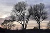
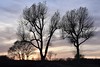
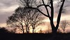
Remains of a Long Barrow..
Source:
Ernst Sprockhoff: Atlas der Megalithgraeber Deutschlands, Teil 1, Schleswig-Holstein
Information dated back to 1933.
Note: N54.44292° E9.89785°
You may be viewing yesterday's version of this page. To see the most up to date information please register for a free account.
")
")
Do not use the above information on other web sites or publications without permission of the contributor.
Nearby Images from Flickr

The above images may not be of the site on this page, but were taken nearby. They are loaded from Flickr so please click on them for image credits.
Click here to see more info for this site
Nearby sites
Click here to view sites on an interactive map of the areaKey: Red: member's photo, Blue: 3rd party photo, Yellow: other image, Green: no photo - please go there and take one, Grey: site destroyed
Download sites to:
KML (Google Earth)
GPX (GPS waypoints)
CSV (Garmin/Navman)
CSV (Excel)
To unlock full downloads you need to sign up as a Contributory Member. Otherwise downloads are limited to 50 sites.
Turn off the page maps and other distractions
Nearby sites listing. In the following links * = Image available
57m NW 323° Altenhof Langbett 1* Long Barrow
107m NE 49° Altenhof Langbett 3* Long Barrow
188m NW 323° Schalenstein Schnellmarker Holz* Sculptured Stone
366m NNE 31° Noer-Lindhoeft Dolmen* Burial Chamber or Dolmen
390m W 269° Altenhof Langbett 4* Long Barrow
568m W 280° Altenhof Langbett 5* Long Barrow
1.3km WSW 237° Altenhof Huegelgrab* Round Barrow(s)
1.5km SE 135° Rothenstein Steingrab* Burial Chamber or Dolmen
1.8km E 79° Behrensbrook Langbett 2* Long Barrow
1.9km E 79° Behrensbrook Langbett 3* Long Barrow
1.9km ENE 79° Behrensbrook Langbett 1* Long Barrow
2.0km E 82° Behrensbrook Langbett 5* Long Barrow
2.0km E 79° Behrensbrook Langbett 4* Long Barrow
2.3km ESE 109° Neudorf-Bornstein Dolmen Burial Chamber or Dolmen
3.5km ENE 68° Hohenkamp Steingrab Burial Chamber or Dolmen
4.8km SSW 202° Holtsee Huegelgrab* Round Barrow(s)
5.1km NNW 339° Hemmelmark Steingrab (13)* Burial Chamber or Dolmen
5.2km WSW 250° Goosefeld Steingrab 2* Burial Chamber or Dolmen
5.3km WSW 242° Goosefeld Dolmen* Burial Chamber or Dolmen
5.4km ENE 70° Lindhoeft Steingrab 5* Round Barrow(s)
5.4km ENE 70° Lindhoeft Steingrab 4* Round Barrow(s)
5.5km NNW 337° Hemmelmark Steingrab (12)* Burial Chamber or Dolmen
5.5km ENE 70° Lindhoeft Steingrab 3* Long Barrow
5.5km ENE 70° Lindhoeft Steingrab 1* Long Barrow
5.5km SSW 211° Holtsee Steinkammer Burial Chamber or Dolmen
View more nearby sites and additional images


 We would like to know more about this location. Please feel free to add a brief description and any relevant information in your own language.
 Wir möchten mehr über diese Stätte erfahren. Bitte zögern Sie nicht, eine kurze Beschreibung und relevante Informationen in Deutsch hinzuzufügen.
 Nous aimerions en savoir encore un peu sur les lieux. S'il vous plaît n'hesitez pas à ajouter une courte description et tous les renseignements pertinents dans votre propre langue.
 Quisieramos informarnos un poco más de las lugares. No dude en añadir una breve descripción y otros datos relevantes en su propio idioma.