


<< Our Photo Pages >> El Gustal Zutarria - Standing Stone (Menhir) in Spain in Pais Vasco
Submitted by irundarra on Tuesday, 22 July 2008 Page Views: 4161
Neolithic and Bronze AgeSite Name: El Gustal Zutarria Alternative Name: Menhir de El Gustal, ValderejoCountry: Spain Region: Pais Vasco Type: Standing Stone (Menhir)
Nearest Town: Vitoria Nearest Village: Lahoz
Latitude: 42.902095N Longitude: 3.243986W
Condition:
| 5 | Perfect |
| 4 | Almost Perfect |
| 3 | Reasonable but with some damage |
| 2 | Ruined but still recognisable as an ancient site |
| 1 | Pretty much destroyed, possibly visible as crop marks |
| 0 | No data. |
| -1 | Completely destroyed |
| 5 | Superb |
| 4 | Good |
| 3 | Ordinary |
| 2 | Not Good |
| 1 | Awful |
| 0 | No data. |
| 5 | Can be driven to, probably with disabled access |
| 4 | Short walk on a footpath |
| 3 | Requiring a bit more of a walk |
| 2 | A long walk |
| 1 | In the middle of nowhere, a nightmare to find |
| 0 | No data. |
| 5 | co-ordinates taken by GPS or official recorded co-ordinates |
| 4 | co-ordinates scaled from a detailed map |
| 3 | co-ordinates scaled from a bad map |
| 2 | co-ordinates of the nearest village |
| 1 | co-ordinates of the nearest town |
| 0 | no data |
Internal Links:
External Links:
")
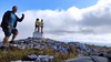
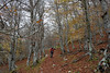
Menhir on the edge of a mountain ridge in Valderejo (Alava).
You may be viewing yesterday's version of this page. To see the most up to date information please register for a free account.
")
")
")
Do not use the above information on other web sites or publications without permission of the contributor.
Nearby Images from Flickr

The above images may not be of the site on this page, but were taken nearby. They are loaded from Flickr so please click on them for image credits.
Click here to see more info for this site
Nearby sites
Click here to view sites on an interactive map of the areaKey: Red: member's photo, Blue: 3rd party photo, Yellow: other image, Green: no photo - please go there and take one, Grey: site destroyed
Download sites to:
KML (Google Earth)
GPX (GPS waypoints)
CSV (Garmin/Navman)
CSV (Excel)
To unlock full downloads you need to sign up as a Contributory Member. Otherwise downloads are limited to 50 sites.
Turn off the page maps and other distractions
Nearby sites listing. In the following links * = Image available
430m N 7° Leron 1 Tumulua Round Barrow(s)
790m NNW 334° Leron 2 Tumulua Round Barrow(s)
1.3km S 182° El Castrillo Eremu Tumularra Barrow Cemetery
1.4km S 186° El Castrillo Tumulua Round Barrow(s)
1.4km S 182° El Castrillo Zutarria Standing Stone (Menhir)
1.6km SW 233° La Barrera 2 Tumulua Round Barrow(s)
1.7km SW 230° La Barrera 1 Tumulua Round Barrow(s)
2.4km SSW 207° San Lorenzo 1 Tumulua Round Barrow(s)
2.7km SW 222° San Lorenzo 2 Tumulua Round Barrow(s)
2.8km W 263° El Paso De Campullido Tumulua Round Barrow(s)
2.8km SW 233° Campullido Zutarria Standing Stone (Menhir)
2.8km SW 230° Campullido 1 Tumulua Round Barrow(s)
2.8km SW 233° Campullido 3 Tumulua Round Barrow(s)
2.9km SW 232° Campullido 2 Tumulua Round Barrow(s)
4.1km E 100° Ribota Zutarria* Standing Stone (Menhir)
4.2km SSE 166° La Cruz De San Miguel Tumulua Round Barrow(s)
5.3km NNE 32° La Granja 3 Tumulua Round Barrow(s)
5.4km NE 38° La Granja 1 Tumulua Round Barrow(s)
5.4km NE 38° La Granja 2 Tumulua Round Barrow(s)
5.4km NE 37° La Granja 4 Tumulua Round Barrow(s)
5.4km S 171° Ribera Tumulua Round Barrow(s)
5.8km E 94° El Manzanal Eremu Tumularra Barrow Cemetery
5.9km NE 40° Matestaje Eremu Tumularra Barrow Cemetery
6.0km SE 142° Santa Gadea Tumulua Round Barrow(s)
6.2km NE 41° Los Hozanillos Eremu Tumularra Barrow Cemetery
View more nearby sites and additional images


 We would like to know more about this location. Please feel free to add a brief description and any relevant information in your own language.
 Wir möchten mehr über diese Stätte erfahren. Bitte zögern Sie nicht, eine kurze Beschreibung und relevante Informationen in Deutsch hinzuzufügen.
 Nous aimerions en savoir encore un peu sur les lieux. S'il vous plaît n'hesitez pas à ajouter une courte description et tous les renseignements pertinents dans votre propre langue.
 Quisieramos informarnos un poco más de las lugares. No dude en añadir una breve descripción y otros datos relevantes en su propio idioma.