


<< Our Photo Pages >> Grande Epine - Stone Row / Alignment in France in Bretagne:Ille-et-Vilaine (35)
Submitted by thecaptain on Saturday, 21 June 2008 Page Views: 3326
Neolithic and Bronze AgeSite Name: Grande Epine Alternative Name: Alignement de Lampouy CCountry: France Département: Bretagne:Ille-et-Vilaine (35) Type: Stone Row / Alignment
Nearest Town: Dinan Nearest Village: Medreac
Latitude: 48.292970N Longitude: 2.06722W
Condition:
| 5 | Perfect |
| 4 | Almost Perfect |
| 3 | Reasonable but with some damage |
| 2 | Ruined but still recognisable as an ancient site |
| 1 | Pretty much destroyed, possibly visible as crop marks |
| 0 | No data. |
| -1 | Completely destroyed |
| 5 | Superb |
| 4 | Good |
| 3 | Ordinary |
| 2 | Not Good |
| 1 | Awful |
| 0 | No data. |
| 5 | Can be driven to, probably with disabled access |
| 4 | Short walk on a footpath |
| 3 | Requiring a bit more of a walk |
| 2 | A long walk |
| 1 | In the middle of nowhere, a nightmare to find |
| 0 | No data. |
| 5 | co-ordinates taken by GPS or official recorded co-ordinates |
| 4 | co-ordinates scaled from a detailed map |
| 3 | co-ordinates scaled from a bad map |
| 2 | co-ordinates of the nearest village |
| 1 | co-ordinates of the nearest town |
| 0 | no data |
Internal Links:
External Links:
I have visited· I would like to visit
johnstone visited on 12th Jun 2022 - their rating: Cond: 2 Amb: 3 Access: 4
Ogham negus have visited here
")
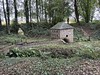
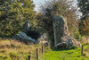
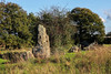
Nine menhirs, all fallen but up to 5 metres in length, make up a line about 45 metres long. The stones are laying between the hedgerows.
You may be viewing yesterday's version of this page. To see the most up to date information please register for a free account.
")
")
")
")
Do not use the above information on other web sites or publications without permission of the contributor.
Nearby Images from Flickr
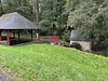
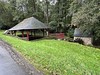
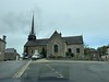
The above images may not be of the site on this page, but were taken nearby. They are loaded from Flickr so please click on them for image credits.
Click here to see more info for this site
Nearby sites
Click here to view sites on an interactive map of the areaKey: Red: member's photo, Blue: 3rd party photo, Yellow: other image, Green: no photo - please go there and take one, Grey: site destroyed
Download sites to:
KML (Google Earth)
GPX (GPS waypoints)
CSV (Garmin/Navman)
CSV (Excel)
To unlock full downloads you need to sign up as a Contributory Member. Otherwise downloads are limited to 50 sites.
Turn off the page maps and other distractions
Nearby sites listing. In the following links * = Image available
29m NW 308° Alignement dit les Rochers (Lampouy)* Stone Row / Alignment
69m SE 127° Bergeons* Stone Row / Alignment
153m ENE 58° Clos du Rocher* Stone Row / Alignment
198m N 358° Roche Longue de Guitté* Standing Stone (Menhir)
208m ENE 66° Les Longs Points* Stone Row / Alignment
425m SE 128° La Roche Carrée* Standing Stone (Menhir)
10.5km E 97° Les Pierres du Diable* Standing Stones
15.5km W 264° Allée Couverte du Bois de la Rabasse* Passage Grave
15.6km E 90° Montmuran menhirs Standing Stones
16.6km WSW 255° Menhir de la Glinaie Standing Stone (Menhir)
18.9km E 90° Cupules de Saint-Symphorien Rock Art
19.5km SSE 160° Coffre de Ty Bot* Cist
19.7km SSE 158° La Roche (Coulon)* Standing Stone (Menhir)
20.0km S 171° Pierre Longue (Iffendic)* Standing Stone (Menhir)
20.1km ESE 120° Roche des Basses Mordelles* Modern Stone Circle etc
20.1km ESE 120° Menhir des Basses Mardelles Standing Stone (Menhir)
20.7km NNW 344° Temple de Mars* Ancient Temple
22.1km SSE 156° Gres de Saint-Meen dolmen* Standing Stone (Menhir)
22.1km NE 52° Menhir du Grand-Herbage Standing Stone (Menhir)
22.2km NNE 20° La Ganterie* Passage Grave
22.2km NNW 341° Monterfil* Ancient Village or Settlement
22.2km NNW 341° Musée Archéologique de Corseul* Museum
22.4km NNW 340° Coriosolis Museum* Museum
22.4km NNW 340° Clos-Mulon* Ancient Village or Settlement
22.6km SSW 196° Menhirs de la Lande de Saint-Jean Standing Stone (Menhir)
View more nearby sites and additional images


 We would like to know more about this location. Please feel free to add a brief description and any relevant information in your own language.
 Wir möchten mehr über diese Stätte erfahren. Bitte zögern Sie nicht, eine kurze Beschreibung und relevante Informationen in Deutsch hinzuzufügen.
 Nous aimerions en savoir encore un peu sur les lieux. S'il vous plaît n'hesitez pas à ajouter une courte description et tous les renseignements pertinents dans votre propre langue.
 Quisieramos informarnos un poco más de las lugares. No dude en añadir una breve descripción y otros datos relevantes en su propio idioma.