 with our Megalithic Portal iPhone app")


<< Our Photo Pages >> Hexentanzplatz (Thale) - Modern Stone Circle etc in Germany in Saxony-Anhalt
Submitted by TimPrevett on Tuesday, 27 February 2007 Page Views: 6387
Modern SitesSite Name: Hexentanzplatz (Thale) Alternative Name: The Witches' CircleCountry: Germany Land: Saxony-Anhalt Type: Modern Stone Circle etc
Nearest Town: Thale
Latitude: 51.734600N Longitude: 11.028800E
Condition:
| 5 | Perfect |
| 4 | Almost Perfect |
| 3 | Reasonable but with some damage |
| 2 | Ruined but still recognisable as an ancient site |
| 1 | Pretty much destroyed, possibly visible as crop marks |
| 0 | No data. |
| -1 | Completely destroyed |
| 5 | Superb |
| 4 | Good |
| 3 | Ordinary |
| 2 | Not Good |
| 1 | Awful |
| 0 | No data. |
| 5 | Can be driven to, probably with disabled access |
| 4 | Short walk on a footpath |
| 3 | Requiring a bit more of a walk |
| 2 | A long walk |
| 1 | In the middle of nowhere, a nightmare to find |
| 0 | No data. |
| 5 | co-ordinates taken by GPS or official recorded co-ordinates |
| 4 | co-ordinates scaled from a detailed map |
| 3 | co-ordinates scaled from a bad map |
| 2 | co-ordinates of the nearest village |
| 1 | co-ordinates of the nearest town |
| 0 | no data |
Internal Links:
External Links:
I have visited· I would like to visit
fornjotr TimPrevett have visited here
 (PID:27959)")
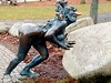
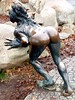
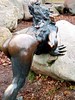
A modern stone circle, complete with devilish figures to mark the site's connection to Walpurgisnacht - May Day Eve - when diabolical deeds and rites were allegedly done. The very name means "Witches' Dancing Place". Now it is a tourist magnet, with spectacular views, a wondrous cable car journey as one of the means to reach the top (this is in the Harz Mountains), and no end of tat pertaining to Witches, Devils, Ghosts and Demons.
You may be viewing yesterday's version of this page. To see the most up to date information please register for a free account.
 (PID:27960)")
Do not use the above information on other web sites or publications without permission of the contributor.
Nearby Images from Flickr
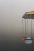
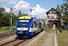
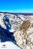
The above images may not be of the site on this page, but were taken nearby. They are loaded from Flickr so please click on them for image credits.
Click here to see more info for this site
Nearby sites
Click here to view sites on an interactive map of the areaKey: Red: member's photo, Blue: 3rd party photo, Yellow: other image, Green: no photo - please go there and take one, Grey: site destroyed
Download sites to:
KML (Google Earth)
GPX (GPS waypoints)
CSV (Garmin/Navman)
CSV (Excel)
To unlock full downloads you need to sign up as a Contributory Member. Otherwise downloads are limited to 50 sites.
Turn off the page maps and other distractions
Nearby sites listing. In the following links * = Image available
722m WNW 283° Rosstrappe* Rock Art
1.9km ESE 104° Glockenstein Thale Natural Stone / Erratic / Other Natural Feature
2.7km NNE 30° Moenchstein Thale Early Christian Sculptured Stone
4.6km NE 55° Teufelsmauer* Natural Stone / Erratic / Other Natural Feature
5.1km NNW 339° Hamburger Wappen Rock Outcrop
8.3km NE 37° Eselstall* Stone Circle
8.8km NNE 12° Königsstein bei Westerhausen* Ancient Temple
8.9km N 359° Steinkreis Börnecke Stone Circle
9.4km NE 53° Rillenstein Westerhausen Standing Stone (Menhir)
9.5km N 2° Prinzenstein* Standing Stone (Menhir)
9.9km N 359° Börnecke Schwefelquelle Holy Well or Sacred Spring
13.3km NNW 330° Derendorfer Forst* Standing Stones
13.4km N 357° Gläserner Mönch Rock Outcrop
13.6km E 89° Gegensteine Rock Outcrop
14.8km NW 321° Heimburg Menhir* Standing Stone (Menhir)
14.9km NW 322° Derenburg Menhir* Standing Stone (Menhir)
14.9km N 11° Klusfelsen (Halberstadt)* Rock Outcrop
15.0km N 10° Fünffingerfelsen* Rock Outcrop
15.0km NW 321° Totenhütte Benzingerode* Chambered Tomb
15.2km NW 320° Grabhügel Benzingerode* Round Barrow(s)
15.4km NW 320° Langhaus Benzingerode* Ancient Village or Settlement
15.9km NW 320° Menhir von Benzingerode* Standing Stone (Menhir)
18.0km N 4° Teufelstisch Halberstadt* Chambered Tomb
18.0km N 4° Städtisches Museum Halberstadt Museum
19.8km SE 127° Der Heisse Stein* Standing Stone (Menhir)
View more nearby sites and additional images


 We would like to know more about this location. Please feel free to add a brief description and any relevant information in your own language.
 Wir möchten mehr über diese Stätte erfahren. Bitte zögern Sie nicht, eine kurze Beschreibung und relevante Informationen in Deutsch hinzuzufügen.
 Nous aimerions en savoir encore un peu sur les lieux. S'il vous plaît n'hesitez pas à ajouter une courte description et tous les renseignements pertinents dans votre propre langue.
 Quisieramos informarnos un poco más de las lugares. No dude en añadir una breve descripción y otros datos relevantes en su propio idioma.