
, Aubrey Burl")
<< Our Photo Pages >> Serra Orrios Megaron - Ancient Temple in Italy in Sardinia (Sardegna)
Submitted by AlexHunger on Thursday, 19 October 2006 Page Views: 4695
Roman, Greek and ClassicalSite Name: Serra Orrios Megaron Alternative Name: Serra Orrios Temple 2Country: Italy Region: Sardinia (Sardegna) Type: Ancient Temple
Nearest Town: Nuoro Nearest Village: Dorgali
Latitude: 40.333660N Longitude: 9.536730E
Condition:
| 5 | Perfect |
| 4 | Almost Perfect |
| 3 | Reasonable but with some damage |
| 2 | Ruined but still recognisable as an ancient site |
| 1 | Pretty much destroyed, possibly visible as crop marks |
| 0 | No data. |
| -1 | Completely destroyed |
| 5 | Superb |
| 4 | Good |
| 3 | Ordinary |
| 2 | Not Good |
| 1 | Awful |
| 0 | No data. |
| 5 | Can be driven to, probably with disabled access |
| 4 | Short walk on a footpath |
| 3 | Requiring a bit more of a walk |
| 2 | A long walk |
| 1 | In the middle of nowhere, a nightmare to find |
| 0 | No data. |
| 5 | co-ordinates taken by GPS or official recorded co-ordinates |
| 4 | co-ordinates scaled from a detailed map |
| 3 | co-ordinates scaled from a bad map |
| 2 | co-ordinates of the nearest village |
| 1 | co-ordinates of the nearest town |
| 0 | no data |
Internal Links:
External Links:
I have visited· I would like to visit
DrewParsons has visited here
")
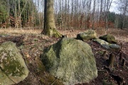
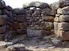
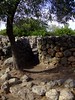
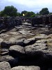
Small ancient Bronze age Temple with benches on the inside well. About the size of a medieval chappel. The rear wall has an indentation on the outside which could have held a votive object. Part of a larger site including major village and other temples.
South East orientation
191 meter Altitude.
You may be viewing yesterday's version of this page. To see the most up to date information please register for a free account.
")
")
Do not use the above information on other web sites or publications without permission of the contributor.
Nearby Images from Flickr


The above images may not be of the site on this page, but were taken nearby. They are loaded from Flickr so please click on them for image credits.
Click here to see more info for this site
Nearby sites
Click here to view sites on an interactive map of the areaKey: Red: member's photo, Blue: 3rd party photo, Yellow: other image, Green: no photo - please go there and take one, Grey: site destroyed
Download sites to:
KML (Google Earth)
GPX (GPS waypoints)
CSV (Garmin/Navman)
CSV (Excel)
To unlock full downloads you need to sign up as a Contributory Member. Otherwise downloads are limited to 50 sites.
Turn off the page maps and other distractions
Nearby sites listing. In the following links * = Image available
18m SSE 149° Serra Orrios Temple* Ancient Temple
56m NNE 26° Serra Orrios Tempio delle Riunione* Ancient Temple
130m ENE 67° Serra Orrios Villaggio Nuragico* Ancient Village or Settlement
535m SSW 210° Oveni Nuraghe* Broch or Nuraghe
1.1km S 184° Noriolo Nuraghe* Broch or Nuraghe
1.2km E 81° Purgatoriu Villaggio Nuragico* Ancient Village or Settlement
1.2km E 87° Purgatoriu Nuraghe* Broch or Nuraghe
1.3km ENE 73° Biristeddi Tomba di Giganti* Chambered Tomb
1.8km WSW 251° Lottoniddo Tomba di Giganti Chambered Tomb
4.5km SE 133° Motorra Dolmen* Burial Chamber or Dolmen
4.6km WSW 258° Biriai Menhirs* Standing Stones
5.4km NNW 340° S'Ena'e Thomes Tomba di Giganti* Chambered Tomb
5.8km ESE 119° Sas Venas Domus de Janas Rock Cut Tomb
6.1km ESE 106° Grotta di Ispinigoli Cave or Rock Shelter
7.0km ENE 63° Torrocone Nuraghe Broch or Nuraghe
7.2km ENE 61° Su Gardu Nuraghe Broch or Nuraghe
7.2km NW 319° Luarzu Nuraghe* Broch or Nuraghe
8.1km NNE 30° Calistru Nuraghe Broch or Nuraghe
8.1km WSW 256° Satzaresu Nuraghe* Broch or Nuraghe
8.2km NNW 335° Puzzittu Nuraghe Broch or Nuraghe
8.2km SE 138° Monte Longu Dolmen* Burial Chamber or Dolmen
8.7km NNE 29° Caraucu Nuraghe Broch or Nuraghe
9.4km SSW 207° Sa Sedda' e sos Carros* Ancient Temple
9.6km WNW 296° Lottoai Domus de Janas Rock Cut Tomb
9.7km NE 34° Turrighe Domus de Janas Rock Cut Tomb
View more nearby sites and additional images


 We would like to know more about this location. Please feel free to add a brief description and any relevant information in your own language.
 Wir möchten mehr über diese Stätte erfahren. Bitte zögern Sie nicht, eine kurze Beschreibung und relevante Informationen in Deutsch hinzuzufügen.
 Nous aimerions en savoir encore un peu sur les lieux. S'il vous plaît n'hesitez pas à ajouter une courte description et tous les renseignements pertinents dans votre propre langue.
 Quisieramos informarnos un poco más de las lugares. No dude en añadir una breve descripción y otros datos relevantes en su propio idioma.