


<< Our Photo Pages >> St Fillan's Holy Pool - Holy Well or Sacred Spring in Scotland in Stirling
Submitted by KiwiBetsy on Tuesday, 12 September 2006 Page Views: 16296
Springs and Holy WellsSite Name: St Fillan's Holy PoolCountry: Scotland County: Stirling Type: Holy Well or Sacred Spring
Nearest Town: Tyndrum
Map Ref: NN35032880
Latitude: 56.422494N Longitude: 4.67626W
Condition:
| 5 | Perfect |
| 4 | Almost Perfect |
| 3 | Reasonable but with some damage |
| 2 | Ruined but still recognisable as an ancient site |
| 1 | Pretty much destroyed, possibly visible as crop marks |
| 0 | No data. |
| -1 | Completely destroyed |
| 5 | Superb |
| 4 | Good |
| 3 | Ordinary |
| 2 | Not Good |
| 1 | Awful |
| 0 | No data. |
| 5 | Can be driven to, probably with disabled access |
| 4 | Short walk on a footpath |
| 3 | Requiring a bit more of a walk |
| 2 | A long walk |
| 1 | In the middle of nowhere, a nightmare to find |
| 0 | No data. |
| 5 | co-ordinates taken by GPS or official recorded co-ordinates |
| 4 | co-ordinates scaled from a detailed map |
| 3 | co-ordinates scaled from a bad map |
| 2 | co-ordinates of the nearest village |
| 1 | co-ordinates of the nearest town |
| 0 | no data |
Internal Links:
External Links:
")
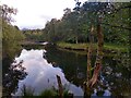
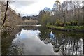
St Fillan's Holy Pool is a natural, deep pool at a sharp bend in the River Fillan. There is now no evidence of stonework but the pool was once divided by a stone dyke into male and female sides.
The tradition for healing varies with the teller but seemed to involve persons whose mental stability was in question. They first had to go to the bottom of the pool and surface with stones. They then had to circle stone cairns, now gone, and place a stone on each cairn. They where then stripped naked and taken to the church at the nearby priory where they were tied to the altar, or a straw covered plinth, or St Fillan's tomb, with his bell either on their chest or suspended over their head for the night. If they had broken free by the morning they were heading for a cure, otherwise the process was started again. The tradition of bathing insane persons in the pool is still known locally but the pool is said to have lost its power when a wild bull was thrown into it in the (?)19th century.
The priory fell into disuse after St Fillan’s death and the stones were taken to build farm buildings and walks. Flagstones from the chapel floor now cover graves.
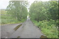
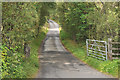
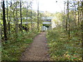
To find the pool take the A82 north from Crianlarich towards Tyndrum, just where the road crosses the River Fillan take the right hand turn onto minor road signed Auchtertyre Farm. Just a short way up this road is an area on the right where you can pull off the road. When we visited (June 2006) there was a huge pile of shingle and a plan to build a path to the pool. We found a stile near the shingle heap and once over that, followed a stone dyke on our right which took us to the pool and an infestation of midges enough to send the sanest person mad.
For more information see Canmore ID 23864.
You may be viewing yesterday's version of this page. To see the most up to date information please register for a free account.
")
")
Do not use the above information on other web sites or publications without permission of the contributor.
Nearby Images from Geograph Britain and Ireland:
©2022(licence)
©2018(licence)
©2022(licence)
©2010(licence)
©2014(licence)
The above images may not be of the site on this page, they are loaded from Geograph.
Please Submit an Image of this site or go out and take one for us!
Click here to see more info for this site
Nearby sites
Key: Red: member's photo, Blue: 3rd party photo, Yellow: other image, Green: no photo - please go there and take one, Grey: site destroyed
Download sites to:
KML (Google Earth)
GPX (GPS waypoints)
CSV (Garmin/Navman)
CSV (Excel)
To unlock full downloads you need to sign up as a Contributory Member. Otherwise downloads are limited to 50 sites.
Turn off the page maps and other distractions
Nearby sites listing. In the following links * = Image available
475m SE 127° Auchtertyre Cairn (NN354285)
1.0km ESE 107° Priest's Well (Strathfillan)* Holy Well or Sacred Spring (NN36022845)
10.8km SSW 196° Inverarnon Stone Circle (NN316185)
12.7km NE 54° Tomochrocher (Glen Lochay) Rock Art (NN4566735827)
14.2km N 10° Tigh Nam Bodach Modern Stone Circle etc (NN38054271)
15.6km NNE 15° MacRee's Cairn (Glen Meurain) Cairn (NN39594375)
17.2km ESE 121° Bealach Driseach* Modern Stone Circle etc (NN49511940)
18.3km W 264° St Conan's Well* Holy Well or Sacred Spring (NN167275)
18.4km ENE 58° Allt Ghaordaidh Standing Stone (Menhir) (NN51013807)
18.4km NE 44° Bhacain* Standing Stone (Menhir) (NN4829041678)
18.9km ENE 67° Corrycharmaig 3 (Glen Lochay) Rock Art (NN52783549)
19.0km NE 45° Caisteal Mhic Neill (Cashlie) Ancient Village or Settlement (NN49024178)
19.1km ENE 63° East Tullich Enclosure (Glen Lochay) Ancient Village or Settlement (NN52363685)
19.2km ENE 59° Caisteal Samhraidh (Killin) Standing Stone (Menhir) (NN519380)
19.2km ENE 66° Corrycharmaig East 2 (Glen Lochay) Rock Art (NN52943588)
19.3km ENE 65° Tullich Rock Art Rock Art (NN52813634)
19.3km ENE 66° Corrycharmaig East 3 (Glen Lochay) Rock Art (NN5305635877)
19.3km ENE 66° Corrycharmaig East 4 (Glen Lochay) Rock Art (NN53103582)
19.4km ENE 66° Duncroisk 2 (Glen Lochay) Rock Art (NN53133584)
19.4km ENE 67° Duncroisk* Rock Art (NN53223582)
19.6km ENE 65° Duncroisk 1 (Glen Lochay) Rock Art (NN53113640)
19.6km ENE 64° Tirai* Standing Stone (Menhir) (NN53083670)
19.7km ENE 65° Duncroisk Crosses Ancient Cross (NN53253641)
19.7km ENE 71° Murlaganmore 2 (Killin) Rock Art (NN53953455)
19.8km ENE 71° Murlaganmore (Killin) Rock Art (NN54023455)
View more nearby sites and additional images


 We would like to know more about this location. Please feel free to add a brief description and any relevant information in your own language.
 Wir möchten mehr über diese Stätte erfahren. Bitte zögern Sie nicht, eine kurze Beschreibung und relevante Informationen in Deutsch hinzuzufügen.
 Nous aimerions en savoir encore un peu sur les lieux. S'il vous plaît n'hesitez pas à ajouter une courte description et tous les renseignements pertinents dans votre propre langue.
 Quisieramos informarnos un poco más de las lugares. No dude en añadir una breve descripción y otros datos relevantes en su propio idioma.