 with our Megalithic Portal iPhone app")


<< Our Photo Pages >> St John's Well (Boughton) - Holy Well or Sacred Spring in England in Northamptonshire
Submitted by HOLYWELL on Tuesday, 29 August 2006 Page Views: 11726
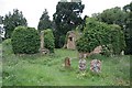
Springs and Holy WellsSite Name: St John's Well (Boughton)Country: England County: Northamptonshire Type: Holy Well or Sacred Spring
Nearest Town: Northampton Nearest Village: Boughton
Map Ref: SP765656
Latitude: 52.283228N Longitude: 0.880006W
Condition:
| 5 | Perfect |
| 4 | Almost Perfect |
| 3 | Reasonable but with some damage |
| 2 | Ruined but still recognisable as an ancient site |
| 1 | Pretty much destroyed, possibly visible as crop marks |
| 0 | No data. |
| -1 | Completely destroyed |
| 5 | Superb |
| 4 | Good |
| 3 | Ordinary |
| 2 | Not Good |
| 1 | Awful |
| 0 | No data. |
| 5 | Can be driven to, probably with disabled access |
| 4 | Short walk on a footpath |
| 3 | Requiring a bit more of a walk |
| 2 | A long walk |
| 1 | In the middle of nowhere, a nightmare to find |
| 0 | No data. |
| 5 | co-ordinates taken by GPS or official recorded co-ordinates |
| 4 | co-ordinates scaled from a detailed map |
| 3 | co-ordinates scaled from a bad map |
| 2 | co-ordinates of the nearest village |
| 1 | co-ordinates of the nearest town |
| 0 | no data |
Internal Links:
External Links:
 (PID:24036)")
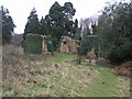
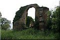
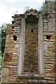
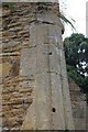
This spring arises from a bank just below the ruined remains of the church into a stone lined chamber. The church used the water for baptism but now it just is overgrown.
You may be viewing yesterday's version of this page. To see the most up to date information please register for a free account.
 (PID:24038)")
 (PID:24037)")
Do not use the above information on other web sites or publications without permission of the contributor.
Nearby Images from Geograph Britain and Ireland:
©2006(licence)
©2010(licence)
©2010(licence)
©2010(licence)
©2010(licence)
The above images may not be of the site on this page, they are loaded from Geograph.
Please Submit an Image of this site or go out and take one for us!
Click here to see more info for this site
Nearby sites
Key: Red: member's photo, Blue: 3rd party photo, Yellow: other image, Green: no photo - please go there and take one, Grey: site destroyed
Download sites to:
KML (Google Earth)
GPX (GPS waypoints)
CSV (Garmin/Navman)
CSV (Excel)
To unlock full downloads you need to sign up as a Contributory Member. Otherwise downloads are limited to 50 sites.
Turn off the page maps and other distractions
Nearby sites listing. In the following links * = Image available
141m SW 226° Shepherd's Race (Boughton) Turf Maze (SP764655)
1.8km W 280° Boughton bowl barrow* Round Barrow(s) (SP74706589)
2.5km NNW 327° Longmans Hill Long Barrow* Long Barrow (SP751677)
5.3km S 191° Northampton Museum and Art Gallery* Museum (SP7559260400)
5.4km S 185° Becket's Well* Holy Well or Sacred Spring (SP761602)
7.4km E 93° Mears Ashby Tumulus* Misc. Earthwork (SP839653)
7.7km SSW 201° Hunsbury* Hillfort (SP738584)
7.7km SSW 213° Upton Bowl Barrow Barrow Cemetery (SP72355909)
9.8km W 268° Great Brington Medieval Cross Ancient Cross (SP6667765176)
11.4km ESE 111° Grendon Cursus Cursus (SP87256174)
13.6km WNW 296° Oster Hill (West Haddon) Cairn (SP64157145)
15.6km SE 142° Holy Well (Olney)* Holy Well or Sacred Spring (SP864535)
15.9km WSW 237° The Larches Ancient Village or Settlement (SP633567)
16.3km ENE 68° Finedon Stone Marker Stone (SP9161871928)
16.8km SSE 151° Holy Well (Ravenstone)* Holy Well or Sacred Spring (SP849510)
17.9km W 261° Borough Hill (Daventry)* Hillfort (SP588626)
20.6km ESE 116° Harrold Barrows* Barrow Cemetery (SP95245702)
20.7km ENE 76° Redlands Farm Long Barrow Long Barrow (SP965710)
20.9km NW 324° Husbands Bosworth Causewayed Enclosure* Causewayed Enclosure (SP64018235)
20.9km ENE 72° Irthlingborough and Stanwick Barrows* Barrow Cemetery (SP963725)
21.0km ENE 75° Stanwick Lakes* Museum (SP96707150)
21.1km NNW 346° Judith's Stone.* Marker Stone (SP7120786000)
21.5km ENE 75° Raunds Ring Ditch Misc. Earthwork (SP972716)
21.9km N 353° Harborough Museum* Museum (SP7342087285)
21.9km N 354° Peter's Pence Stone* Standing Stone (Menhir) (SP740874)
View more nearby sites and additional images


 We would like to know more about this location. Please feel free to add a brief description and any relevant information in your own language.
 Wir möchten mehr über diese Stätte erfahren. Bitte zögern Sie nicht, eine kurze Beschreibung und relevante Informationen in Deutsch hinzuzufügen.
 Nous aimerions en savoir encore un peu sur les lieux. S'il vous plaît n'hesitez pas à ajouter une courte description et tous les renseignements pertinents dans votre propre langue.
 Quisieramos informarnos un poco más de las lugares. No dude en añadir una breve descripción y otros datos relevantes en su propio idioma.