

<< Our Photo Pages >> Hellig Hågen - Standing Stone (Menhir) in Denmark in Bornholm
Submitted by AlexHunger on Monday, 28 August 2006 Page Views: 4104
Neolithic and Bronze AgeSite Name: Hellig HågenCountry: Denmark County: Bornholm Type: Standing Stone (Menhir)
Nearest Town: Nexø
Latitude: 55.078261N Longitude: 15.022064E
Condition:
| 5 | Perfect |
| 4 | Almost Perfect |
| 3 | Reasonable but with some damage |
| 2 | Ruined but still recognisable as an ancient site |
| 1 | Pretty much destroyed, possibly visible as crop marks |
| 0 | No data. |
| -1 | Completely destroyed |
| 5 | Superb |
| 4 | Good |
| 3 | Ordinary |
| 2 | Not Good |
| 1 | Awful |
| 0 | No data. |
| 5 | Can be driven to, probably with disabled access |
| 4 | Short walk on a footpath |
| 3 | Requiring a bit more of a walk |
| 2 | A long walk |
| 1 | In the middle of nowhere, a nightmare to find |
| 0 | No data. |
| 5 | co-ordinates taken by GPS or official recorded co-ordinates |
| 4 | co-ordinates scaled from a detailed map |
| 3 | co-ordinates scaled from a bad map |
| 2 | co-ordinates of the nearest village |
| 1 | co-ordinates of the nearest town |
| 0 | no data |
Internal Links:
External Links:
I have visited· I would like to visit
Boeddel visited on 31st Aug 2016 - their rating: Cond: 4 Amb: 5 Access: 3
")
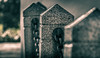
The male greeting stone of the island, Hellig Hågen, is standing in a not very well known area of the Åker Plantation. Please notice the "face," which turns left with sulking mouth and eye in the top middle.
Description of Jeanne Cordua, Bornholm
You may be viewing yesterday's version of this page. To see the most up to date information please register for a free account.
")
")
")
")
Do not use the above information on other web sites or publications without permission of the contributor.
Nearby Images from Flickr

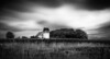
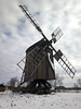
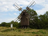
The above images may not be of the site on this page, but were taken nearby. They are loaded from Flickr so please click on them for image credits.
Click here to see more info for this site
Nearby sites
Click here to view sites on an interactive map of the areaKey: Red: member's photo, Blue: 3rd party photo, Yellow: other image, Green: no photo - please go there and take one, Grey: site destroyed
Download sites to:
KML (Google Earth)
GPX (GPS waypoints)
CSV (Garmin/Navman)
CSV (Excel)
To unlock full downloads you need to sign up as a Contributory Member. Otherwise downloads are limited to 50 sites.
Turn off the page maps and other distractions
Nearby sites listing. In the following links * = Image available
843m NNE 33° Højlyngen Bautasten* Standing Stone (Menhir)
1.2km NNE 19° Kraagesten Bautasten* Standing Stone (Menhir)
1.7km SSW 195° Hjortebakken Bautasten* Standing Stones
2.1km SW 219° Skovgaard Bautasten* Standing Stone (Menhir)
2.1km ESE 116° Troldesten Fårebrovejen* Natural Stone / Erratic / Other Natural Feature
2.8km SW 218° Egeby røser burial ground* Cairn
3.1km ESE 105° Gryet Bautasten* Standing Stones
3.3km WSW 257° Kastelsgaard Bautasten 2* Standing Stone (Menhir)
3.3km WSW 257° Kastelsgaard Bautasten 1* Standing Stone (Menhir)
3.5km SSW 202° Kiellingeby Skåltegn* Rock Art
3.5km NE 37° Rødehøj Bautasten* Standing Stone (Menhir)
3.5km ENE 70° Albasten i Paradisbakkerne* Rock Art
3.6km NE 36° Rødehøj Gravrøse* Cairn
3.7km ESE 120° Bodilskerstenen 4* Sculptured Stone
3.7km ESE 119° Langedestenen* Sculptured Stone
3.7km ESE 119° Bodilskerstenen 3* Sculptured Stone
3.7km ESE 119° Bodilskerstenen 5* Carving
3.7km ESE 120° Fandens hat* Sculptured Stone
3.7km E 79° Gamleborg i Paradisbakkerne* Hillfort
4.0km ESE 103° Slamrebjerg Bautasten 1* Standing Stone (Menhir)
4.1km ESE 110° Slamrebjerg Bautasten 2* Standing Stone (Menhir)
4.1km ESE 103° Slamrebjerg Bautasten 3* Standing Stone (Menhir)
4.6km ENE 65° Majdalen Skåltegn* Rock Art
4.7km SSE 154° Stenseby Bønnestenene Jættestue 1* Passage Grave
4.8km ENE 62° Nasken Bautasten* Standing Stone (Menhir)
View more nearby sites and additional images


 We would like to know more about this location. Please feel free to add a brief description and any relevant information in your own language.
 Wir möchten mehr über diese Stätte erfahren. Bitte zögern Sie nicht, eine kurze Beschreibung und relevante Informationen in Deutsch hinzuzufügen.
 Nous aimerions en savoir encore un peu sur les lieux. S'il vous plaît n'hesitez pas à ajouter une courte description et tous les renseignements pertinents dans votre propre langue.
 Quisieramos informarnos un poco más de las lugares. No dude en añadir una breve descripción y otros datos relevantes en su propio idioma.