


<< Text Pages >> Cayonu - Ancient Village or Settlement in Turkey
Submitted by AlexHunger on Friday, 04 August 2006 Page Views: 12835
Multi-periodSite Name: Cayonu Alternative Name: Çayönü TepesiCountry: Turkey Type: Ancient Village or Settlement
Nearest Town: Ergani Nearest Village: Sesverenpınar
Latitude: 38.218286N Longitude: 39.725585E
Condition:
| 5 | Perfect |
| 4 | Almost Perfect |
| 3 | Reasonable but with some damage |
| 2 | Ruined but still recognisable as an ancient site |
| 1 | Pretty much destroyed, possibly visible as crop marks |
| 0 | No data. |
| -1 | Completely destroyed |
| 5 | Superb |
| 4 | Good |
| 3 | Ordinary |
| 2 | Not Good |
| 1 | Awful |
| 0 | No data. |
| 5 | Can be driven to, probably with disabled access |
| 4 | Short walk on a footpath |
| 3 | Requiring a bit more of a walk |
| 2 | A long walk |
| 1 | In the middle of nowhere, a nightmare to find |
| 0 | No data. |
| 5 | co-ordinates taken by GPS or official recorded co-ordinates |
| 4 | co-ordinates scaled from a detailed map |
| 3 | co-ordinates scaled from a bad map |
| 2 | co-ordinates of the nearest village |
| 1 | co-ordinates of the nearest town |
| 0 | no data |
Internal Links:
External Links:
Ancient Village or Settlement in Diyarbakır Province, Turkey.
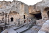
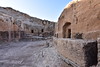
Çayönü is a neolithic settlement dating from 7250 to 6750 BCE. Excavations, were first undertaken by Professor Robert Braidwood of the Oriental Institute and Department of Anthropology at the University of Chicago, between 1964-1978 and 1985-1991 by Mehmet Özdogan. The settlement was inhabited between from Pre-Pottery Neolithic A to PPNB. Numerous skulls were found buried under the dwellings. At Çayönü the oldest known terrazzo floor, which was produced with concrete made of burned lime, was discovered.
Çayönü is probably the place where the first known pigs were domesticated. The wild fauna includes wild boar, wild sheep, wild goat and cervids. Evidence at the site suggests that domesticated emmer and einkorn wheat were cultivated early on.
The TAY Project website.
You may be viewing yesterday's version of this page. To see the most up to date information please register for a free account.
Do not use the above information on other web sites or publications without permission of the contributor.
Nearby Images from Flickr
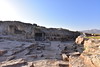
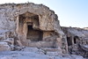
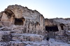
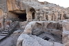
The above images may not be of the site on this page, but were taken nearby. They are loaded from Flickr so please click on them for image credits.
Click here to see more info for this site
Nearby sites
Click here to view sites on an interactive map of the areaKey: Red: member's photo, Blue: 3rd party photo, Yellow: other image, Green: no photo - please go there and take one, Grey: site destroyed
Download sites to:
KML (Google Earth)
GPX (GPS waypoints)
CSV (Garmin/Navman)
CSV (Excel)
To unlock full downloads you need to sign up as a Contributory Member. Otherwise downloads are limited to 50 sites.
Turn off the page maps and other distractions
Nearby sites listing. In the following links * = Image available
3.0km E 92° Yayvantepe Ancient Village or Settlement
4.7km WSW 256° Kikan Harabesi Ancient Village or Settlement
6.2km W 277° Gri Havsarik Ancient Village or Settlement
7.4km N 10° Papazgölü Ancient Village or Settlement
8.1km NNE 26° Gölbent Mevkii Ancient Village or Settlement
11.1km NE 40° Kötekan Ancient Village or Settlement
24.5km ESE 109° Girikihaciyan Ancient Village or Settlement
32.6km E 82° Fortress Egil Ancient Temple
45.7km NNW 339° Boytepe Ancient Village or Settlement
58.9km NNE 18° Cinaz III Ancient Village or Settlement
68.8km NW 317° Elazig Museum Museum
69.0km NW 322° Harput Relief* Sculptured Stone
80.3km ENE 64° Birkleyn Caves Cave or Rock Shelter
87.9km WNW 285° Cafer Höyük Ancient Village or Settlement
90.1km WSW 253° Nemrut Dag* Artificial Mound
99.0km WSW 252° Arsameia* Ancient Village or Settlement
100.4km ESE 117° Hakemi Use Tepe Ancient Village or Settlement
102.8km WSW 252° Cendere Bridge* Ancient Trackway
103.6km SSW 202° Başbük Ancient Village or Settlement
103.6km SSW 202° Tasli Tepe Ancient Village or Settlement
104.8km ESE 116° Ziyaret Tepe Ancient Village or Settlement
108.6km WSW 247° Karakus Tumulus* Artificial Mound
111.3km ESE 112° Salat Tepe Ancient Village or Settlement
113.8km ESE 113° Müslümantepe Ancient Village or Settlement
116.3km WSW 248° Kilisik Statue Sculptured Stone
View more nearby sites and additional images


 We would like to know more about this location. Please feel free to add a brief description and any relevant information in your own language.
 Wir möchten mehr über diese Stätte erfahren. Bitte zögern Sie nicht, eine kurze Beschreibung und relevante Informationen in Deutsch hinzuzufügen.
 Nous aimerions en savoir encore un peu sur les lieux. S'il vous plaît n'hesitez pas à ajouter une courte description et tous les renseignements pertinents dans votre propre langue.
 Quisieramos informarnos un poco más de las lugares. No dude en añadir una breve descripción y otros datos relevantes en su propio idioma.