

<< Our Photo Pages >> Cronk Sumark - Vitrified Fort in Channel Islands and Isle of Man in Isle of Man
Submitted by rocket on Thursday, 15 February 2001 Page Views: 7186
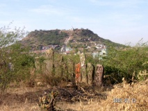
Neolithic and Bronze AgeSite Name: Cronk SumarkCountry: Channel Islands and Isle of Man Island: Isle of Man Type: Vitrified Fort
Map Ref: SC392941
Latitude: 54.317085N Longitude: 4.473605W
Condition:
| 5 | Perfect |
| 4 | Almost Perfect |
| 3 | Reasonable but with some damage |
| 2 | Ruined but still recognisable as an ancient site |
| 1 | Pretty much destroyed, possibly visible as crop marks |
| 0 | No data. |
| -1 | Completely destroyed |
| 5 | Superb |
| 4 | Good |
| 3 | Ordinary |
| 2 | Not Good |
| 1 | Awful |
| 0 | No data. |
| 5 | Can be driven to, probably with disabled access |
| 4 | Short walk on a footpath |
| 3 | Requiring a bit more of a walk |
| 2 | A long walk |
| 1 | In the middle of nowhere, a nightmare to find |
| 0 | No data. |
| 5 | co-ordinates taken by GPS or official recorded co-ordinates |
| 4 | co-ordinates scaled from a detailed map |
| 3 | co-ordinates scaled from a bad map |
| 2 | co-ordinates of the nearest village |
| 1 | co-ordinates of the nearest town |
| 0 | no data |
Internal Links:
External Links:
I have visited· I would like to visit
FrothNinja has visited here
")
The hill itself is quite a tough climb - so the walk while not long in distance, may take a little while - once I reached the top, I saw that a more easy access may have been by walking around the back of the hill, after going over the second style, but i didn't investigate much further.
The outline of earthworks for this small outpost can be clearly seen, though they are overgrown in places with gorse.
Relaxing (and I needed to) on the top once I reached it I appreciated the positioning - a 180 degree view of the northern plain of the Isle of Man, and, on a clear day, I suspect a good distance out to sea would have made this an excellent lookout point.
Very peaceful place, with the occasional car or bike on the road below.
You may be viewing yesterday's version of this page. To see the most up to date information please register for a free account.
")
")
")
")
")
Do not use the above information on other web sites or publications without permission of the contributor.
Click here to see more info for this site
Nearby sites
Click here to view sites on an interactive map of the areaKey: Red: member's photo, Blue: 3rd party photo, Yellow: other image, Green: no photo - please go there and take one, Grey: site destroyed
Download sites to:
KML (Google Earth)
GPX (GPS waypoints)
CSV (Garmin/Navman)
CSV (Excel)
To unlock full downloads you need to sign up as a Contributory Member. Otherwise downloads are limited to 50 sites.
![]()
Turn off the page maps and other distractions
Nearby sites listing. In the following links * = Image available
2.5km SW 218° Oaie ny Foawr (Sulby) Round Barrow(s) (SC376922)
4.2km ENE 61° Cronk Aust Cist* Cist (SC4396)
4.3km ESE 117° Glen Auldyn Cist* Cist (SC4392)
5.4km WNW 285° Runic Cross (Ballaugh Old Church)* Ancient Cross
5.7km W 260° Magher ny Clogh Mooar* Standing Stone (Menhir) (SC335933)
5.9km WNW 299° Ballateare Viking burial mound Round Barrow(s)
6.0km E 92° Killeaba Mound* Natural Stone / Erratic / Other Natural Feature
6.1km NW 314° Kirk Patrick Burial Mound Artificial Mound (SC350985)
6.9km W 263° Orrisdale* Cairn (SC323935)
7.2km SSW 208° Druidale* Ancient Village or Settlement (SC356878)
8.5km ESE 123° Cashtal-yn-Ard* Chambered Tomb (SC46228923)
9.1km NE 37° Thor Cross, Bride* Ancient Cross (NX449012)
9.2km WSW 238° Cronk Guckley mounds* Round Barrow(s) (SC31238945)
9.4km ESE 113° Ballagory Horned Cairn* Cairn (SC47759012)
10.1km WSW 238° Michael Standing Stone and rock art* Standing Stone (Menhir) (SC30468908)
10.3km SE 143° Spiral stone (Ballaragh)* Rock Art (SC4520085670)
10.6km E 100° St Maughold's Well Holy Well or Sacred Spring (SC49619193)
10.8km SSE 152° King Orry's Grave* Chambered Tomb (SC43898439)
12.2km SW 235° Corvalley Cairn* Cairn (SC28938747)
12.4km SW 235° Ballakaighen* Ancient Village or Settlement (SC287874)
13.2km SSE 162° Cloven Stones* Chambered Tomb (SC42928141)
14.8km SW 230° Meir ny Foawr (Knocksharry) Stone Circle (SC27588495)
14.9km SW 230° Staarvey Farm Cist burial Cist
15.1km SSE 165° Glebe Well (Lonan Church) Holy Well or Sacred Spring (SC42577937)
15.1km SSW 201° Keill Vreeshey (Crosby) Sculptured Stone (SC332802)
View more nearby sites and additional images


 We would like to know more about this location. Please feel free to add a brief description and any relevant information in your own language.
 Wir möchten mehr über diese Stätte erfahren. Bitte zögern Sie nicht, eine kurze Beschreibung und relevante Informationen in Deutsch hinzuzufügen.
 Nous aimerions en savoir encore un peu sur les lieux. S'il vous plaît n'hesitez pas à ajouter une courte description et tous les renseignements pertinents dans votre propre langue.
 Quisieramos informarnos un poco más de las lugares. No dude en añadir una breve descripción y otros datos relevantes en su propio idioma.