 with our Megalithic Portal iPhone app")


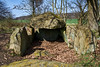
<< Our Photo Pages >> Gobbin Steingrab 2 - Chambered Tomb in Germany in Mecklenburg-Western Pomerania
Submitted by AlexHunger on Sunday, 23 April 2006 Page Views: 2672
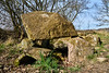
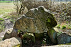
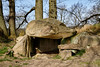
Neolithic and Bronze AgeSite Name: Gobbin Steingrab 2Country: Germany Land: Mecklenburg-Western Pomerania Type: Chambered Tomb
Nearest Town: Bergen Nearest Village: Preetz
Latitude: 54.355466N Longitude: 13.603452E
Condition:
| 5 | Perfect |
| 4 | Almost Perfect |
| 3 | Reasonable but with some damage |
| 2 | Ruined but still recognisable as an ancient site |
| 1 | Pretty much destroyed, possibly visible as crop marks |
| 0 | No data. |
| -1 | Completely destroyed |
| 5 | Superb |
| 4 | Good |
| 3 | Ordinary |
| 2 | Not Good |
| 1 | Awful |
| 0 | No data. |
| 5 | Can be driven to, probably with disabled access |
| 4 | Short walk on a footpath |
| 3 | Requiring a bit more of a walk |
| 2 | A long walk |
| 1 | In the middle of nowhere, a nightmare to find |
| 0 | No data. |
| 5 | co-ordinates taken by GPS or official recorded co-ordinates |
| 4 | co-ordinates scaled from a detailed map |
| 3 | co-ordinates scaled from a bad map |
| 2 | co-ordinates of the nearest village |
| 1 | co-ordinates of the nearest town |
| 0 | no data |
Internal Links:
External Links:
")
Interesting stones close to Sprockhoff 500, Ziegensteine. As yet unregistered chambered tomb or field stones in a coincidentally similar pattern within a small tumulus?
Island of Rügen
You may be viewing yesterday's version of this page. To see the most up to date information please register for a free account.
Do not use the above information on other web sites or publications without permission of the contributor.
Nearby Images from Flickr

The above images may not be of the site on this page, but were taken nearby. They are loaded from Flickr so please click on them for image credits.
Click here to see more info for this site
Nearby sites
Click here to view sites on an interactive map of the areaKey: Red: member's photo, Blue: 3rd party photo, Yellow: other image, Green: no photo - please go there and take one, Grey: site destroyed
Download sites to:
KML (Google Earth)
GPX (GPS waypoints)
CSV (Garmin/Navman)
CSV (Excel)
To unlock full downloads you need to sign up as a Contributory Member. Otherwise downloads are limited to 50 sites.
Turn off the page maps and other distractions
Nearby sites listing. In the following links * = Image available
72m ENE 73° Gobbin Grabhuegel* Round Barrow(s)
90m N 3° Gobbin Ziegensteine* Long Barrow
948m NE 53° Preetz-Burtewitz Steingrab 4* Chambered Tomb
983m NE 51° Preetz-Burtewitz Steingrab 3* Chambered Tomb
1.1km NE 52° Preetz-Burtewitz Steingrab 2* Chambered Tomb
1.2km NE 51° Lancken-Granitz Steingrab 1* Chambered Tomb
1.2km NE 50° Lancken-Granitz Steingrab 2* Chambered Tomb
1.3km NE 50° Lancken-Granitz Steingrab 3* Chambered Tomb
1.3km NE 51° Lancken-Granitz Steingrab 4* Chambered Tomb
1.6km E 82° Preetz-Burtewitz Steingrab 1* Chambered Tomb
1.8km NNE 30° Lancken-Granitz Steingrab 5* Chambered Tomb
2.0km W 272° Gross Stresow Opferstein Natural Stone / Erratic / Other Natural Feature
2.1km WNW 282° Nistelitz Grabhuegel 2* Round Barrow(s)
2.2km WNW 286° Nistelitz Grabhuegel 1* Round Barrow(s)
2.5km W 275° Nadelitz Steingrab 5* Chambered Tomb
2.6km W 275° Nadelitz Steingrab 4* Chambered Tomb
2.7km W 269° Nadelitz Grabhuegel 5 Round Barrow(s)
2.7km W 274° Nadelitz Steingrab 3* Chambered Tomb
3.1km W 261° Nadelitz Grabhuegel 4* Round Barrow(s)
3.1km ENE 59° Garftitz Steingrab* Chambered Tomb
3.1km W 279° Nadelitz Steingrab 6* Chambered Tomb
3.1km WNW 287° Seelvitz Steingrab 3* Chambered Tomb
3.1km W 261° Nadelitz Grabhuegel 3* Round Barrow(s)
3.2km W 262° Nadelitz Grabhuegel 2* Round Barrow(s)
3.2km NE 41° Blieschow Grabhuegel 1* Round Barrow(s)
View more nearby sites and additional images


 We would like to know more about this location. Please feel free to add a brief description and any relevant information in your own language.
 Wir möchten mehr über diese Stätte erfahren. Bitte zögern Sie nicht, eine kurze Beschreibung und relevante Informationen in Deutsch hinzuzufügen.
 Nous aimerions en savoir encore un peu sur les lieux. S'il vous plaît n'hesitez pas à ajouter une courte description et tous les renseignements pertinents dans votre propre langue.
 Quisieramos informarnos un poco más de las lugares. No dude en añadir una breve descripción y otros datos relevantes en su propio idioma.