

<< Our Photo Pages >> Anta da Fonte Coberta - Burial Chamber or Dolmen in Portugal in Vila Real
Submitted by AlexHunger on Monday, 10 April 2006 Page Views: 10360
Neolithic and Bronze AgeSite Name: Anta da Fonte CobertaCountry: Portugal Distrito: Vila Real Type: Burial Chamber or Dolmen
Nearest Town: Vila Real Nearest Village: Vila Chã
Latitude: 41.334870N Longitude: 7.47159W
Condition:
| 5 | Perfect |
| 4 | Almost Perfect |
| 3 | Reasonable but with some damage |
| 2 | Ruined but still recognisable as an ancient site |
| 1 | Pretty much destroyed, possibly visible as crop marks |
| 0 | No data. |
| -1 | Completely destroyed |
| 5 | Superb |
| 4 | Good |
| 3 | Ordinary |
| 2 | Not Good |
| 1 | Awful |
| 0 | No data. |
| 5 | Can be driven to, probably with disabled access |
| 4 | Short walk on a footpath |
| 3 | Requiring a bit more of a walk |
| 2 | A long walk |
| 1 | In the middle of nowhere, a nightmare to find |
| 0 | No data. |
| 5 | co-ordinates taken by GPS or official recorded co-ordinates |
| 4 | co-ordinates scaled from a detailed map |
| 3 | co-ordinates scaled from a bad map |
| 2 | co-ordinates of the nearest village |
| 1 | co-ordinates of the nearest town |
| 0 | no data |
Internal Links:
External Links:
I have visited· I would like to visit
43559959 would like to visit
annikacunha visited on 17th Oct 2022 - their rating: Cond: 3 Amb: 3 Access: 5
DrewParsons Magalhaes have visited here
")
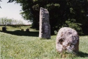
Classic Dolmen in Northern Portugal.
From Magalhaes in May 2006: On the IP4 (Bragança-Porto), after the Murça exit, take the Alijó exit to the N212 and follow in that direction. After the sign to Pagarinhos to the left, a couple more kms and the anta has a sign on the right side of the road. It is in well preserved and has remnants of an entrance tunnel and some red paint on the inside, namely on the third stone counting from left, where there is also a modern graffito. There are a few large, flat granitic outcrops near it, roughly to the North, which you will see when approaching it.
From Drew Parsons in April 2010: The standard format seven orthostat chamber stands 3 metres high and is one of the most important in northern Portugal. There are ochre marks and engravings on the orthostats, but I was unable to identify them for certain on my visit. There are rupestrian art sites nearby in and around Vila Chã all signposted. Travelling from the south on N212 go 1.5 kilometres past the junction for Chã and Vila Chã to reach the track to the dolmen on the left (west). The dolmen is easily seen from the road at this point.
You may be viewing yesterday's version of this page. To see the most up to date information please register for a free account.
")
")
")
")
")
")
")
")
")
")
")
")
Do not use the above information on other web sites or publications without permission of the contributor.
Click here to see more info for this site
Nearby sites
Click here to view sites on an interactive map of the areaKey: Red: member's photo, Blue: 3rd party photo, Yellow: other image, Green: no photo - please go there and take one, Grey: site destroyed
Download sites to:
KML (Google Earth)
GPX (GPS waypoints)
CSV (Garmin/Navman)
CSV (Excel)
To unlock full downloads you need to sign up as a Contributory Member. Otherwise downloads are limited to 50 sites.
Turn off the page maps and other distractions
Nearby sites listing. In the following links * = Image available
1.7km WSW 237° Sepultura de Vila Chã* Rock Cut Tomb
3.2km NNW 342° Castro do Pópulo* Castro or Chafurdão
10.4km SW 233° Castro de Sabrosa* Castro or Chafurdão
10.7km NE 45° Castro de Palheiros Castro or Chafurdão
12.2km WSW 251° Mamoa de Madorras* Burial Chamber or Dolmen
13.9km NW 305° Ponte Romana de Arco* Rock Art
16.3km ESE 114° Anta de Zedes* Burial Chamber or Dolmen
18.3km WNW 284° São Bento (Vila Real)* Castro or Chafurdão
18.5km WSW 252° Santuário de Panóias* Barrow Cemetery
21.0km W 279° Gravuras Rupestres do Alto da Mão do Homem Rock Art
21.3km WNW 301° Veiga dos Fornos* Rock Art
23.1km W 260° Museu de Arqueologia e Numismática de Vila Real* Museum
23.4km WSW 259° Museu da Vila Velha* Museum
26.7km SW 226° Fonte do Milho* Ancient Village or Settlement
27.6km NW 311° Mamoa do Alto do Cotorino Round Barrow(s)
28.0km ESE 123° Anta de Vilarinho da Castanheira* Burial Chamber or Dolmen
28.3km NNE 12° Castro de Ribas Castro or Chafurdão
29.2km NNE 13° Algeriz Altar de Sacrificios Barrow Cemetery
31.1km WNW 297° Castro da Cerva Castro or Chafurdão
31.7km SSW 200° Citânia da Longa Castro or Chafurdão
32.1km S 180° Areita Dolmen* Burial Chamber or Dolmen
32.5km N 354° Castro de Loivos Castro or Chafurdão
33.4km S 175° Anta do Turgal* Burial Chamber or Dolmen
34.5km N 9° Castro de Vilanova Castro or Chafurdão
34.6km S 173° Sepultura antropomórfica de Cômbaros Rock Cut Tomb
View more nearby sites and additional images


 We would like to know more about this location. Please feel free to add a brief description and any relevant information in your own language.
 Wir möchten mehr über diese Stätte erfahren. Bitte zögern Sie nicht, eine kurze Beschreibung und relevante Informationen in Deutsch hinzuzufügen.
 Nous aimerions en savoir encore un peu sur les lieux. S'il vous plaît n'hesitez pas à ajouter une courte description et tous les renseignements pertinents dans votre propre langue.
 Quisieramos informarnos un poco más de las lugares. No dude en añadir una breve descripción y otros datos relevantes en su propio idioma.