

<< Our Photo Pages >> Meifod - Ancient Cross in Wales in Powys
Submitted by TimPrevett on Tuesday, 21 March 2006 Page Views: 9701
Early Medieval (Dark Age)Site Name: MeifodCountry: Wales County: Powys Type: Ancient Cross
Nearest Village: Meifod
Map Ref: SJ155132
Latitude: 52.709842N Longitude: 3.252178W
Condition:
| 5 | Perfect |
| 4 | Almost Perfect |
| 3 | Reasonable but with some damage |
| 2 | Ruined but still recognisable as an ancient site |
| 1 | Pretty much destroyed, possibly visible as crop marks |
| 0 | No data. |
| -1 | Completely destroyed |
| 5 | Superb |
| 4 | Good |
| 3 | Ordinary |
| 2 | Not Good |
| 1 | Awful |
| 0 | No data. |
| 5 | Can be driven to, probably with disabled access |
| 4 | Short walk on a footpath |
| 3 | Requiring a bit more of a walk |
| 2 | A long walk |
| 1 | In the middle of nowhere, a nightmare to find |
| 0 | No data. |
| 5 | co-ordinates taken by GPS or official recorded co-ordinates |
| 4 | co-ordinates scaled from a detailed map |
| 3 | co-ordinates scaled from a bad map |
| 2 | co-ordinates of the nearest village |
| 1 | co-ordinates of the nearest town |
| 0 | no data |
Internal Links:
External Links:
")
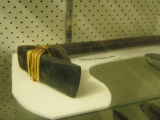
In the church of St Tysilio and St Mary, there is a most unusual of cross slabs, incorporating Latin, Greek (some say Maltese), and Viking elements, with splendid knotwork & interlace.
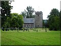
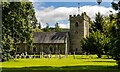
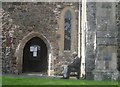
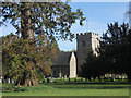
The site has had a church, according to legend, since 550AD.The churchyard is huge,and its location is a low, raised platform, in a flat river valley, with encircling hils. There are a number of yew trees.
The cross slab is dated according to whom you read. Ninth, tenth or twelfth century. In the twelth century, nearby Mathrafal was the seat of The Princes of Powys, and Meifod was its corresponding religious centre. It is postulated this may be a memorial to one of the Princes of Powys. Later Welshpool took the power, and Valle Crucis near Llangollen overtook its religious significance.
Parking in churchyard if visiting church. Access subject to church opening. During our visit, some of the external area around the bell tower was fenced off due to possibility of falling loose masonry. If visiting, at least put a donation for the church upkeep, or buy a guidebook, or some of the souvenirs at the back. An important site preserving a fascinating piece of history.
You may be viewing yesterday's version of this page. To see the most up to date information please register for a free account.
")
")
")
Do not use the above information on other web sites or publications without permission of the contributor.
Nearby Images from Geograph Britain and Ireland:
©2008(licence)
©2007(licence)
©2023(licence)
©2015(licence)
©2011(licence)
The above images may not be of the site on this page, they are loaded from Geograph.
Please Submit an Image of this site or go out and take one for us!
Click here to see more info for this site
Nearby sites
Key: Red: member's photo, Blue: 3rd party photo, Yellow: other image, Green: no photo - please go there and take one, Grey: site destroyed
Download sites to:
KML (Google Earth)
GPX (GPS waypoints)
CSV (Garmin/Navman)
CSV (Excel)
To unlock full downloads you need to sign up as a Contributory Member. Otherwise downloads are limited to 50 sites.
Turn off the page maps and other distractions
Nearby sites listing. In the following links * = Image available
604m NW 320° Meifod Cursus Cursus (SJ15121367)
657m NNW 335° Meifod Cursus Cursus (SJ15231380)
2.3km S 184° Ffynnon y Clawdd Llesg* Holy Well or Sacred Spring (SJ153109)
5.2km SW 225° Pentre Camp Hillfort (SJ11730957)
6.4km E 91° Trinity Well, Guilsfield Holy Well or Sacred Spring (SJ21881297)
6.5km NNW 345° St Myllin's Well* Holy Well or Sacred Spring (SJ1393819533)
6.8km E 91° Gaer Fawr (Guilsfield)* Hillfort (SJ223130)
7.1km ENE 62° Collfryn Ring Ditch Misc. Earthwork (SJ21861650)
7.8km SW 218° Tanllan Enclosure Ancient Village or Settlement (SJ10600715)
8.4km SW 216° Ffynnon Fair (Llanfair Caereinion)* Holy Well or Sacred Spring (SJ1036106480)
8.9km SE 128° Maen Llog* Standing Stone (Menhir) (SJ225076)
9.2km SE 129° Powysland Museum* Museum (SJ226073)
9.4km SE 128° Welshpool Eisteddfod Circle* Modern Stone Circle etc (SJ2286307263)
10.3km SE 140° Sarn-y-bryn-caled II Cursus Cursus (SJ21970523)
10.3km SE 141° Sarn-y-bryn-caled II Cursus Cursus (SJ21830505)
10.4km SE 142° Welshpool A Cursus Cursus (SJ21820497)
10.4km SE 143° Welshpool A Cursus Cursus (SJ21640480)
10.5km SE 141° Sarn-y-Bryn-Caled* Timber Circle (SJ219049)
10.8km ENE 74° Trinity Well, Arddleen Holy Well or Sacred Spring (SJ25951594)
11.6km N 7° Llwyn Bryn Dinas* Hillfort (SJ172247)
11.8km N 350° Aber Rhaeadr* Standing Stone (Menhir) (SJ1369624820)
12.2km N 349° Meusydd Henge Complex* Henge (SJ134252)
12.4km ESE 115° Trinity Well, Cletterwood Holy Well or Sacred Spring (SJ26650780)
12.5km WSW 253° The Rustica Stone Early Christian Sculptured Stone (SJ0340809775)
12.8km SSE 156° Dyffryn Lane, Berriew* Henge (SJ2044101409)
View more nearby sites and additional images


 We would like to know more about this location. Please feel free to add a brief description and any relevant information in your own language.
 Wir möchten mehr über diese Stätte erfahren. Bitte zögern Sie nicht, eine kurze Beschreibung und relevante Informationen in Deutsch hinzuzufügen.
 Nous aimerions en savoir encore un peu sur les lieux. S'il vous plaît n'hesitez pas à ajouter une courte description et tous les renseignements pertinents dans votre propre langue.
 Quisieramos informarnos un poco más de las lugares. No dude en añadir una breve descripción y otros datos relevantes en su propio idioma.