


<< Our Photo Pages >> Chalybeate Spring - Holy Well or Sacred Spring in England in Kent
Submitted by DavidCWoods on Monday, 01 August 2005 Page Views: 14839
Springs and Holy WellsSite Name: Chalybeate Spring Alternative Name: Tunbridge WellsCountry: England County: Kent Type: Holy Well or Sacred Spring
Nearest Town: Tunbridge Wells
Map Ref: TQ5815138798
Latitude: 51.126634N Longitude: 0.258676E
Condition:
| 5 | Perfect |
| 4 | Almost Perfect |
| 3 | Reasonable but with some damage |
| 2 | Ruined but still recognisable as an ancient site |
| 1 | Pretty much destroyed, possibly visible as crop marks |
| 0 | No data. |
| -1 | Completely destroyed |
| 5 | Superb |
| 4 | Good |
| 3 | Ordinary |
| 2 | Not Good |
| 1 | Awful |
| 0 | No data. |
| 5 | Can be driven to, probably with disabled access |
| 4 | Short walk on a footpath |
| 3 | Requiring a bit more of a walk |
| 2 | A long walk |
| 1 | In the middle of nowhere, a nightmare to find |
| 0 | No data. |
| 5 | co-ordinates taken by GPS or official recorded co-ordinates |
| 4 | co-ordinates scaled from a detailed map |
| 3 | co-ordinates scaled from a bad map |
| 2 | co-ordinates of the nearest village |
| 1 | co-ordinates of the nearest town |
| 0 | no data |
Internal Links:
External Links:
I have visited· I would like to visit
ScottHK visited on 27th Aug 2020 - their rating: Cond: 3 Amb: 4 Access: 5
")
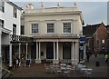
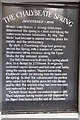
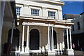
Discovered (or at least publicised) by Dudley, Lord North in 1606. A village grew up around the spring, and this evolved into the town destined to become so popular during the Regency period.
I visited the site in July 2005 and the spring is now situated under a Georgian house in The Pantiles, a pedestrian area in the historic centre of the town.
You may be viewing yesterday's version of this page. To see the most up to date information please register for a free account.
")
")
Do not use the above information on other web sites or publications without permission of the contributor.
Nearby Images from Geograph Britain and Ireland:
©2017(licence)

©2017(licence)
©2017(licence)
©2017(licence)

©2018(licence)
The above images may not be of the site on this page, they are loaded from Geograph.
Please Submit an Image of this site or go out and take one for us!
Click here to see more info for this site
Nearby sites
Key: Red: member's photo, Blue: 3rd party photo, Yellow: other image, Green: no photo - please go there and take one, Grey: site destroyed
Download sites to:
KML (Google Earth)
GPX (GPS waypoints)
CSV (Garmin/Navman)
CSV (Excel)
To unlock full downloads you need to sign up as a Contributory Member. Otherwise downloads are limited to 50 sites.
Turn off the page maps and other distractions
Nearby sites listing. In the following links * = Image available
38m NNW 329° Tunbridge Wells Chalybeate Spring* Holy Well or Sacred Spring (TQ58133883)
744m NNE 21° Tunbridge Wells Museum Museum (TQ584395)
819m NE 54° Calverley Grounds Standing Stones (TQ588393)
1.5km WNW 299° Denny Bottom Rock Shelters Cave or Rock Shelter (TQ568395)
1.5km WNW 302° Toad Rock* Natural Stone / Erratic / Other Natural Feature (TQ5681539560)
1.8km WNW 285° Happy Valley Cave or Rock Shelter (TQ564392)
2.1km W 261° High Rocks Rock Shelters* Cave or Rock Shelter (TQ56093842)
2.1km WSW 258° High Rocks Hillfort* Hillfort (TQ561383)
2.3km WSW 257° High Rocks Settlement Ancient Village or Settlement (TQ559382)
2.6km WSW 258° Adam's Well* Holy Well or Sacred Spring (TQ55623820)
4.4km W 263° Harness Well Holy Well or Sacred Spring (TQ538381)
4.8km SSW 198° Eridge Old Park Caves and Spring Cave or Rock Shelter (TQ568342)
5.6km NNE 29° Capel Castle Hill (Kent) Hillfort (TQ607438)
5.9km S 185° Saxonbury Fort Hillfort (TQ578329)
8.9km WNW 296° Stonewall Park Rock Shelters Cave or Rock Shelter (TQ49974241)
10.2km NW 310° The Chiding stone* Natural Stone / Erratic / Other Natural Feature (TQ50064509)
10.3km ESE 105° Lady Well (Lamberhurst)* Holy Well or Sacred Spring (TQ682364)
11.7km S 179° St Dunstan's Well Holy Well or Sacred Spring (TQ587271)
12.2km WSW 242° Lone Oak Spring Holy Well or Sacred Spring (TQ475328)
13.1km WSW 237° Greenwood Gate Clump Enclosure Ancient Village or Settlement (TQ47373127)
13.1km WSW 241° A.A.Milne & E.H.Shephard Memorial* Modern Stone Circle etc (TQ468321)
13.7km WSW 238° Peat Lump Hill* Round Barrow(s) (TQ46773120)
13.8km SW 231° Kings Standing* Ancient Village or Settlement (TQ477298)
14.3km NE 44° Hob's pool Holy Well or Sacred Spring (TQ678494)
14.6km ESE 109° Lady well (Bedgebury) Holy Well or Sacred Spring (TQ7212534404)
View more nearby sites and additional images


 We would like to know more about this location. Please feel free to add a brief description and any relevant information in your own language.
 Wir möchten mehr über diese Stätte erfahren. Bitte zögern Sie nicht, eine kurze Beschreibung und relevante Informationen in Deutsch hinzuzufügen.
 Nous aimerions en savoir encore un peu sur les lieux. S'il vous plaît n'hesitez pas à ajouter une courte description et tous les renseignements pertinents dans votre propre langue.
 Quisieramos informarnos un poco más de las lugares. No dude en añadir una breve descripción y otros datos relevantes en su propio idioma.