


<< Text Pages >> Trun menhir - Standing Stone (Menhir) in France in Normandie:Orne (61)
Submitted by TheCaptain on Sunday, 08 May 2005 Page Views: 3303
Neolithic and Bronze AgeSite Name: Trun menhir Alternative Name: Pierre Levée de TrunCountry: France Département: Normandie:Orne (61) Type: Standing Stone (Menhir)
Nearest Town: Argentan Nearest Village: Trun
Latitude: 48.842000N Longitude: 0.030300E
Condition:
| 5 | Perfect |
| 4 | Almost Perfect |
| 3 | Reasonable but with some damage |
| 2 | Ruined but still recognisable as an ancient site |
| 1 | Pretty much destroyed, possibly visible as crop marks |
| 0 | No data. |
| -1 | Completely destroyed |
| 5 | Superb |
| 4 | Good |
| 3 | Ordinary |
| 2 | Not Good |
| 1 | Awful |
| 0 | No data. |
| 5 | Can be driven to, probably with disabled access |
| 4 | Short walk on a footpath |
| 3 | Requiring a bit more of a walk |
| 2 | A long walk |
| 1 | In the middle of nowhere, a nightmare to find |
| 0 | No data. |
| 5 | co-ordinates taken by GPS or official recorded co-ordinates |
| 4 | co-ordinates scaled from a detailed map |
| 3 | co-ordinates scaled from a bad map |
| 2 | co-ordinates of the nearest village |
| 1 | co-ordinates of the nearest town |
| 0 | no data |
Be the first person to rate this site - see the 'Contribute!' box in the right hand menu.
Internal Links:
External Links:
I have visited· I would like to visit
TheCaptain couldn't find on 2nd May 2005 There is a menhir somehow incorporated into a southern corner of the church tower of this village where I stopped right by it to buy food and look at the village maps. How stupid I was to miss this one forgetting its existence only while I was there. Its why I went there ! Guess the lateness of getting my lunch was taking its toll.
IMPORTANT NOTE: Position of site taken from detailed map source.
You may be viewing yesterday's version of this page. To see the most up to date information please register for a free account.
Do not use the above information on other web sites or publications without permission of the contributor.
Nearby Images from Flickr
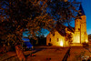
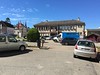


The above images may not be of the site on this page, but were taken nearby. They are loaded from Flickr so please click on them for image credits.
Click here to see more info for this site
Nearby sites
Click here to view sites on an interactive map of the areaKey: Red: member's photo, Blue: 3rd party photo, Yellow: other image, Green: no photo - please go there and take one, Grey: site destroyed
Download sites to:
KML (Google Earth)
GPX (GPS waypoints)
CSV (Garmin/Navman)
CSV (Excel)
To unlock full downloads you need to sign up as a Contributory Member. Otherwise downloads are limited to 50 sites.
Turn off the page maps and other distractions
Nearby sites listing. In the following links * = Image available
2.7km WNW 302° Dolmen dit Pierre-Levée (Fontaine)* Burial Chamber or Dolmen
4.6km S 170° Menhir dit Pierre du Bourdeu Standing Stone (Menhir)
6.2km W 261° Camp Celtique de Bière* Ancient Village or Settlement
7.9km E 82° Dolmen du Boijos Burial Chamber or Dolmen
10.6km SSW 211° Moulins-sur-Orne burial chamber Burial Chamber or Dolmen
12.7km SSE 155° La Pierre-Levée (Bourge-Saint-Leonard) Standing Stone (Menhir)
13.2km SSE 154° La Pierre Levée (Silly)* Standing Stone (Menhir)
14.2km SSW 201° Sarceaux burial chamber Burial Chamber or Dolmen
14.8km WSW 254° Tumulus des Hogues* Round Barrow(s)
14.8km WSW 255° Dolmen dit Pierre-aux-Bignes* Burial Chamber or Dolmen
18.8km SW 236° La Courbe Burial Chamber or Dolmen
18.8km SW 236° La Pierre Tournoire, La Courbe* Standing Stone (Menhir)
19.3km SW 236° Camp du Bas de la Courbe Ancient Village or Settlement
19.8km SW 235° Vieux Chateaux Ancient Village or Settlement
20.4km WNW 301° Menhir de Soulangy* Standing Stone (Menhir)
20.5km NW 314° Menhir d'Olendon* Standing Stone (Menhir)
20.7km WSW 239° Menhir de la Courbe* Standing Stone (Menhir)
21.3km WSW 243° Crève-Coeur Menhir Standing Stone (Menhir)
22.0km NNE 28° Pierre Tournante (Livarot)* Standing Stone (Menhir)
22.5km NW 309° Langrais menhirs* Standing Stones
23.3km NW 308° Mont Joly* Ancient Village or Settlement
23.3km NW 308° Bons Tassilly polissoirs* Polissoir
23.5km NNW 331° Tumuli de Condé-sur-Ifs* Chambered Cairn
23.6km NNW 331° La Butte du Hu* Chambered Cairn
24.4km WNW 295° Menhir de la Grurie* Standing Stone (Menhir)
View more nearby sites and additional images


 We would like to know more about this location. Please feel free to add a brief description and any relevant information in your own language.
 Wir möchten mehr über diese Stätte erfahren. Bitte zögern Sie nicht, eine kurze Beschreibung und relevante Informationen in Deutsch hinzuzufügen.
 Nous aimerions en savoir encore un peu sur les lieux. S'il vous plaît n'hesitez pas à ajouter une courte description et tous les renseignements pertinents dans votre propre langue.
 Quisieramos informarnos un poco más de las lugares. No dude en añadir una breve descripción y otros datos relevantes en su propio idioma.