


<< Our Photo Pages >> Broad Well (Alton Priors) - Holy Well or Sacred Spring in England in Wiltshire
Submitted by kernunos on Sunday, 24 April 2005 Page Views: 12030
Springs and Holy WellsSite Name: Broad Well (Alton Priors) Alternative Name: Brade WyllCountry: England County: Wiltshire Type: Holy Well or Sacred Spring
Nearest Town: Marlborough Nearest Village: Alton Priors
Map Ref: SU108622
Latitude: 51.358770N Longitude: 1.846279W
Condition:
| 5 | Perfect |
| 4 | Almost Perfect |
| 3 | Reasonable but with some damage |
| 2 | Ruined but still recognisable as an ancient site |
| 1 | Pretty much destroyed, possibly visible as crop marks |
| 0 | No data. |
| -1 | Completely destroyed |
| 5 | Superb |
| 4 | Good |
| 3 | Ordinary |
| 2 | Not Good |
| 1 | Awful |
| 0 | No data. |
| 5 | Can be driven to, probably with disabled access |
| 4 | Short walk on a footpath |
| 3 | Requiring a bit more of a walk |
| 2 | A long walk |
| 1 | In the middle of nowhere, a nightmare to find |
| 0 | No data. |
| 5 | co-ordinates taken by GPS or official recorded co-ordinates |
| 4 | co-ordinates scaled from a detailed map |
| 3 | co-ordinates scaled from a bad map |
| 2 | co-ordinates of the nearest village |
| 1 | co-ordinates of the nearest town |
| 0 | no data |
Internal Links:
External Links:
 (PID:168720)")
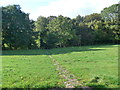
This spring rises in a bend in the stream that runs in front of the lovely Alton Priors church. The water can be seen bubbling up through the sandy stream bed, an attribute that often leads to the name 'boiling well', but not in this case. A 'Bradewelle' (meaning 'Wide Spring') is mentioned as early as 825 in the Saxon Charters. In fact, the name Alton probably derives from 'aewielle' and 'tun' meaning 'the farm by the spring'. Broadwell is likely to be the very spring that gave Alton Priors its name.
You may be viewing yesterday's version of this page. To see the most up to date information please register for a free account.
 (PID:169312)")
Do not use the above information on other web sites or publications without permission of the contributor.
Nearby Images from Geograph Britain and Ireland:
©2014(licence)
![SU1062 : Maslen's Farmhouse [1] by Michael Dibb](https://s3.geograph.org.uk/geophotos/06/57/44/6574423_bf70a7ab_120x120.jpg)
©2020(licence)
![SU1062 : Maslen's Farmhouse [2] by Michael Dibb](https://s0.geograph.org.uk/geophotos/06/57/44/6574424_5d0bc8cf_120x120.jpg)
©2020(licence)
![SU1062 : From Stanton St Bernard to Wansdyke and return [79] by Michael Dibb](https://s2.geograph.org.uk/geophotos/06/57/44/6574426_0244b7e7_120x120.jpg)
©2020(licence)
![SU1062 : From Stanton St Bernard to Wansdyke and return [80] by Michael Dibb](https://s0.geograph.org.uk/geophotos/06/57/44/6574432_4ae035ce_120x120.jpg)
©2020(licence)
The above images may not be of the site on this page, they are loaded from Geograph.
Please Submit an Image of this site or go out and take one for us!
Click here to see more info for this site
Nearby sites
Key: Red: member's photo, Blue: 3rd party photo, Yellow: other image, Green: no photo - please go there and take one, Grey: site destroyed
Download sites to:
KML (Google Earth)
GPX (GPS waypoints)
CSV (Garmin/Navman)
CSV (Excel)
To unlock full downloads you need to sign up as a Contributory Member. Otherwise downloads are limited to 50 sites.
Turn off the page maps and other distractions
Nearby sites listing. In the following links * = Image available
100m S 181° All Saints (Alton Priors)* Holed Stone (SU108621)
193m SSW 201° Alton Barnes Modern Stone* Modern Stone Circle etc (SU10736202)
1.3km NNE 20° Adam's Grave (Alton Barnes)* Long Barrow (SU1123363386)
1.4km NNE 14° Walkers Hill Earthwork* Misc. Earthwork (SU11136355)
1.5km NNE 23° Adam's Graves Round Barrows 2* Round Barrow(s) (SU114636)
1.5km N 355° Alton Barnes White Horse* Hill Figure or Geoglyph (SU10676373)
1.6km NNE 30° Adam's Grave's Round Barrows 1* Round Barrow(s) (SU116636)
1.7km N 357° Milk Hill Bowl Barrow* Round Barrow(s) (SU10716387)
1.7km W 275° All Saints Church Stone* Standing Stone (Menhir) (SU0908262340)
1.8km NNW 336° Milk Hill Cross Dyke* Misc. Earthwork (SU10086381)
1.8km NE 40° Knap Hill Bowl Barrow 2 Round Barrow(s) (SU11976358)
1.9km NE 41° Knap Hill Bowl Barrow 1* Round Barrow(s) (SU12056362)
1.9km NE 43° Knap Hill* Causewayed Enclosure (SU121636)
1.9km SSW 208° The Hanging Stone (Wiltshire)* Standing Stone (Menhir) (SU099605)
2.0km NNE 23° New Town Tumuli Round Barrow(s) (SU11596403)
2.3km N 5° Eald Burh Ancient Village or Settlement (SU11016450)
2.8km NNW 328° Tan Hill Tumuli* Round Barrow(s) (SU0932164561)
3.0km NW 324° Tan Hill Cross Dyke* Misc. Earthwork (SU0900364643)
3.1km NW 306° Rybury Camp* Hillfort (SU083640)
3.2km N 350° All Cannings Down Tumulus* Round Barrow(s) (SU1023765380)
3.5km W 279° All Cannings* Modern Stone Circle etc (SU07326275)
3.5km ENE 61° Gopher Wood Barrows Barrow Cemetery (SU139639)
3.5km NNE 32° Wansdyke* Misc. Earthwork (SU127652)
3.6km NW 306° Tan Hill Stone Circle* Modern Stone Circle etc (SU079643)
3.7km NNE 16° Langdean Bottom* Stone Circle (SU11806574)
View more nearby sites and additional images


 We would like to know more about this location. Please feel free to add a brief description and any relevant information in your own language.
 Wir möchten mehr über diese Stätte erfahren. Bitte zögern Sie nicht, eine kurze Beschreibung und relevante Informationen in Deutsch hinzuzufügen.
 Nous aimerions en savoir encore un peu sur les lieux. S'il vous plaît n'hesitez pas à ajouter une courte description et tous les renseignements pertinents dans votre propre langue.
 Quisieramos informarnos un poco más de las lugares. No dude en añadir una breve descripción y otros datos relevantes en su propio idioma.