
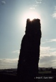

<< Our Photo Pages >> Ardgroom Standing Stone - Standing Stone (Menhir) in Ireland (Republic of) in Co. Cork
Submitted by Klingon on Thursday, 21 April 2005 Page Views: 7369
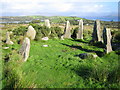
Neolithic and Bronze AgeSite Name: Ardgroom Standing StoneCountry: Ireland (Republic of) County: Co. Cork Type: Standing Stone (Menhir)
Nearest Town: Ardgroom
Map Ref: V7001855615
Latitude: 51.738381N Longitude: 9.882416W
Condition:
| 5 | Perfect |
| 4 | Almost Perfect |
| 3 | Reasonable but with some damage |
| 2 | Ruined but still recognisable as an ancient site |
| 1 | Pretty much destroyed, possibly visible as crop marks |
| 0 | No data. |
| -1 | Completely destroyed |
| 5 | Superb |
| 4 | Good |
| 3 | Ordinary |
| 2 | Not Good |
| 1 | Awful |
| 0 | No data. |
| 5 | Can be driven to, probably with disabled access |
| 4 | Short walk on a footpath |
| 3 | Requiring a bit more of a walk |
| 2 | A long walk |
| 1 | In the middle of nowhere, a nightmare to find |
| 0 | No data. |
| 5 | co-ordinates taken by GPS or official recorded co-ordinates |
| 4 | co-ordinates scaled from a detailed map |
| 3 | co-ordinates scaled from a bad map |
| 2 | co-ordinates of the nearest village |
| 1 | co-ordinates of the nearest town |
| 0 | no data |
Internal Links:
External Links:
I have visited· I would like to visit
Klingon visited on 28th Mar 2005 - their rating: Cond: 3 Amb: 3 Access: 5
")
This stone has got a Swastika symbol on it's surface. This isn't ancient.
You may be viewing yesterday's version of this page. To see the most up to date information please register for a free account.
Do not use the above information on other web sites or publications without permission of the contributor.
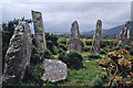
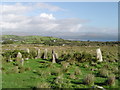
Nearby Images from Geograph Britain and Ireland:
©2006(licence)
©2011(licence)
©2006(licence)
©2006(licence)
©2007(licence)
The above images may not be of the site on this page, they are loaded from Geograph.
Please Submit an Image of this site or go out and take one for us!
Click here to see more info for this site
Nearby sites
Click here to view sites on an interactive map of the areaKey: Red: member's photo, Blue: 3rd party photo, Yellow: other image, Green: no photo - please go there and take one, Grey: site destroyed
Download sites to:
KML (Google Earth)
GPX (GPS waypoints)
CSV (Garmin/Navman)
CSV (Excel)
To unlock full downloads you need to sign up as a Contributory Member. Otherwise downloads are limited to 50 sites.
Turn off the page maps and other distractions
Nearby sites listing. In the following links * = Image available
806m SSE 160° Ardgroom Outward SW Standing Stones
895m ESE 106° Ardgroom Stone Circle* Stone Circle (V7087255339)
1.3km E 91° Ardgroom Outward NE pair Standing Stones (V71295556)
2.0km ENE 64° Ardgroom Outward NE* Stone Circle (V71885646)
3.2km WSW 238° Barees* Stone Row / Alignment (V6728453990)
3.3km SW 235° Barrees Megalithic Structure* Not Known (by us)
4.4km ESE 109° Rabhach's Cave - Cummeengeera Glen* Natural Stone / Erratic / Other Natural Feature
4.5km ESE 107° Cummeengeera enclosure and standing stone* Standing Stone (Menhir)
4.9km ESE 102° Deelis Hut Site* Ancient Village or Settlement
4.9km SW 220° Crumpane Copper Mine* Ancient Mine, Quarry or other Industry
5.1km WSW 236° Ballycrovane* Standing Stone (Menhir) (V6571152906)
5.1km ENE 66° Cashelkeelty W* Stone Circle
5.2km ENE 66° Cashelkeelty Stone Row* Stone Row / Alignment
5.2km ENE 66° Cashelkeelty E* Stone Circle (V74815757)
5.3km WSW 251° Faranfada Stone Circle (V650540)
5.3km SSW 208° Caheravart* Ancient Village or Settlement (V67405096)
5.4km E 91° Shronebirrane* Stone Circle (V7542355403)
5.7km SSW 200° Gowlane* Standing Stone (Menhir) (V67905031)
5.9km ENE 66° Cashelkeelty Standing Stones* Standing Stones (V75485784)
6.0km SW 227° Bofickil wedge tomb* Wedge Tomb
6.2km WSW 236° Na hAoraí stone pair* Standing Stones
6.5km SSW 197° Kilmackowen Standing Stone* Standing Stone (Menhir) (V67994948)
6.5km WSW 247° Gortgarriff stone cross* Ancient Cross
6.5km WSW 245° Cailleach Beara* Natural Stone / Erratic / Other Natural Feature (V6453)
6.6km SSW 196° Kilmackowen Wedge Tomb* Wedge Tomb (V6805249356)
View more nearby sites and additional images


 We would like to know more about this location. Please feel free to add a brief description and any relevant information in your own language.
 Wir möchten mehr über diese Stätte erfahren. Bitte zögern Sie nicht, eine kurze Beschreibung und relevante Informationen in Deutsch hinzuzufügen.
 Nous aimerions en savoir encore un peu sur les lieux. S'il vous plaît n'hesitez pas à ajouter une courte description et tous les renseignements pertinents dans votre propre langue.
 Quisieramos informarnos un poco más de las lugares. No dude en añadir una breve descripción y otros datos relevantes en su propio idioma.