


<< Our Photo Pages >> Cherry Garden Hill Barrow - Round Barrow(s) in England in Kent
Submitted by coldrum on Wednesday, 23 July 2008 Page Views: 5076
Neolithic and Bronze AgeSite Name: Cherry Garden Hill BarrowCountry: England
NOTE: This site is 1.4 km away from the location you searched for.
County: Kent Type: Round Barrow(s)
Nearest Town: Folkstone
Map Ref: TR20833801
Latitude: 51.098848N Longitude: 1.152660E
Condition:
| 5 | Perfect |
| 4 | Almost Perfect |
| 3 | Reasonable but with some damage |
| 2 | Ruined but still recognisable as an ancient site |
| 1 | Pretty much destroyed, possibly visible as crop marks |
| 0 | No data. |
| -1 | Completely destroyed |
| 5 | Superb |
| 4 | Good |
| 3 | Ordinary |
| 2 | Not Good |
| 1 | Awful |
| 0 | No data. |
| 5 | Can be driven to, probably with disabled access |
| 4 | Short walk on a footpath |
| 3 | Requiring a bit more of a walk |
| 2 | A long walk |
| 1 | In the middle of nowhere, a nightmare to find |
| 0 | No data. |
| 5 | co-ordinates taken by GPS or official recorded co-ordinates |
| 4 | co-ordinates scaled from a detailed map |
| 3 | co-ordinates scaled from a bad map |
| 2 | co-ordinates of the nearest village |
| 1 | co-ordinates of the nearest town |
| 0 | no data |
Be the first person to rate this site - see the 'Contribute!' box in the right hand menu.
Internal Links:
External Links:
I have visited· I would like to visit
Brian_Eyes visited on 31st May 2019 - their rating: Cond: 3 Amb: 4 Access: 3 It has a WW2 pillbox on top. Nice spot, worth a visit. About an hour's walk from Folkestone West rail station.
")
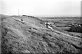
Tumulus in Folkstone. This might be the one that had a pillbox built into during the Second World War which destroyed the central inhumation.
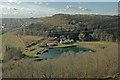
Mention of the barrow here. From Exploring Kent's Past: "Cherry Gardens Hill Tumulus, on the property of the Folkestone Waterworks Company. A primary crouched interment was found in the centre of the tumulus, with the body aligned east-west. It was probably male and c.25-35 years old at its death, and c.5' 7" tall. A small piece of rough ironstone was found at the feet, c. eighteen inches above the skeleton was a thin slab of Folkestone stone, broken, but probably shaped on three sides. The skeleton was surrounded by a blackish layer, but with no evidence of fire. A secondary burial aligned north-west to south-east was found on the edge of the tumulus . The barrow was slightly damaged by the construction of a pillbox on its summit in 1940. The barrow is now c. 1.3m high and is still crowned by the pillbox; its perimeter has been enlarged by spoil from the 1940 digging. The bones from the primary interment are in Folkestone Museum; the other finds cannot be traced." http://extranet7.kent.gov.uk/ExploringKentsPast/SingleResult.aspx?uid=MKE5584
You may be viewing yesterday's version of this page. To see the most up to date information please register for a free account.
")
Do not use the above information on other web sites or publications without permission of the contributor.
Nearby Images from Geograph Britain and Ireland:
©2014(licence)
©2008(licence)
©2008(licence)
©2014(licence)
©2014(licence)
The above images may not be of the site on this page, they are loaded from Geograph.
Please Submit an Image of this site or go out and take one for us!
Click here to see more info for this site
Nearby sites
Key: Red: member's photo, Blue: 3rd party photo, Yellow: other image, Green: no photo - please go there and take one, Grey: site destroyed
Download sites to:
KML (Google Earth)
GPX (GPS waypoints)
CSV (Garmin/Navman)
CSV (Excel)
To unlock full downloads you need to sign up as a Contributory Member. Otherwise downloads are limited to 50 sites.
Turn off the page maps and other distractions
Nearby sites listing. In the following links * = Image available
579m ESE 103° Caesar's Camp (Folkstone)* Hillfort (TR214379)
888m E 94° Castle Hill Barrows Round Barrow(s) (TR21723798)
1.4km E 85° Sugerloaf Hill Holy Well Holy Well or Sacred Spring (TR222382)
2.6km WNW 283° Elm Gardens Mound Artificial Mound (TR183385)
3.0km SE 137° Folkestone moot stones* Marker Stone (TR22963589)
4.4km N 8° Little Foxholt Barrows Round Barrow(s) (TR21284239)
4.9km W 279° Tolsford Hill Barrows Round Barrow(s) (TR160386)
5.3km E 86° Capel-le-Ferne Bowl Barrow* Round Barrow(s) (TR26113860)
5.5km NW 304° St. Eadburg's Well Holy Well or Sacred Spring (TR16174088)
5.5km WNW 303° St. Ethelburga's Well (Lyminge)* Holy Well or Sacred Spring (TR161408)
5.5km NW 305° Lyminge Anglo Saxon Feasting Hall* Ancient Palace (TR1620440970)
5.6km WSW 239° Holywelle Holy Well or Sacred Spring (TR161349)
5.7km NW 314° Lyminge Barrow Round Barrow(s) (TR16504181)
6.1km WSW 254° Willow Wood Barrow Round Barrow(s) (TR15023612)
6.5km NNE 24° St John's Well (Swingfield) Holy Well or Sacred Spring (TR23224401)
6.8km ENE 56° Moseling's Hole Denehole Ancient Mine, Quarry or other Industry (TR26324199)
6.9km NW 318° Tumulus, Boyke Lane* Round Barrow(s) (TR15944290)
8.3km NE 49° Minnis Barrows Round Barrow(s) (TR26834375)
8.5km WNW 303° Tumulus farm Barrow* Round Barrow(s) (TR1348742346)
8.7km WNW 303° Stone Street Barrow Round Barrow(s) (TR13354250)
8.8km NW 307° West Wood Barrows Barrow Cemetery (TR136430)
8.8km NW 313° Mockbegger Farm Barrow Round Barrow(s) (TR14074372)
8.9km NNW 331° Elhampark Wood Barrows* Round Barrow(s) (TR16154558)
9.2km WNW 302° Swinyard's Hill Tumulus Round Barrow(s) (TR12784255)
9.4km ENE 70° Whinless Down Barrows Round Barrow(s) (TR29514167)
View more nearby sites and additional images


 We would like to know more about this location. Please feel free to add a brief description and any relevant information in your own language.
 Wir möchten mehr über diese Stätte erfahren. Bitte zögern Sie nicht, eine kurze Beschreibung und relevante Informationen in Deutsch hinzuzufügen.
 Nous aimerions en savoir encore un peu sur les lieux. S'il vous plaît n'hesitez pas à ajouter une courte description et tous les renseignements pertinents dans votre propre langue.
 Quisieramos informarnos un poco más de las lugares. No dude en añadir una breve descripción y otros datos relevantes en su propio idioma.