


<< Other Photo Pages >> Maidstone Museum & Art Gallery - Museum in England in Kent
Submitted by vicky on Monday, 02 July 2007 Page Views: 10774
MuseumsSite Name: Maidstone Museum & Art GalleryCountry: England
NOTE: This site is 3.8 km away from the location you searched for.
County: Kent Type: Museum
Nearest Town: Maidstone
Map Ref: TQ7593456003 Landranger Map Number: 178
Latitude: 51.276009N Longitude: 0.520980E
Condition:
| 5 | Perfect |
| 4 | Almost Perfect |
| 3 | Reasonable but with some damage |
| 2 | Ruined but still recognisable as an ancient site |
| 1 | Pretty much destroyed, possibly visible as crop marks |
| 0 | No data. |
| -1 | Completely destroyed |
| 5 | Superb |
| 4 | Good |
| 3 | Ordinary |
| 2 | Not Good |
| 1 | Awful |
| 0 | No data. |
| 5 | Can be driven to, probably with disabled access |
| 4 | Short walk on a footpath |
| 3 | Requiring a bit more of a walk |
| 2 | A long walk |
| 1 | In the middle of nowhere, a nightmare to find |
| 0 | No data. |
| 5 | co-ordinates taken by GPS or official recorded co-ordinates |
| 4 | co-ordinates scaled from a detailed map |
| 3 | co-ordinates scaled from a bad map |
| 2 | co-ordinates of the nearest village |
| 1 | co-ordinates of the nearest town |
| 0 | no data |
Internal Links:
External Links:
I have visited· I would like to visit
chrisbu would like to visit
coldrum visited - their rating: Cond: 5 Amb: 4 Access: 5
Address: St Faiths Street, ME14 1LH
Phone: 01622 754497
Opening Hours: Monday to Saturday 10am-5.15pm, Sunday 11am-4pm
Admission: Not Known
Note: Stone Age Kent, 16th July, see comment. See comment for Stone Age Event on 21st July.
You may be viewing yesterday's version of this page. To see the most up to date information please register for a free account.
Do not use the above information on other web sites or publications without permission of the contributor.
davidmorgan has found this location on Google Street View:
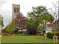
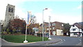
Nearby Images from Geograph Britain and Ireland:
©2013(licence)

©2013(licence)
©2013(licence)

©2013(licence)
©2019(licence)
The above images may not be of the site on this page, they are loaded from Geograph.
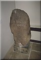
Please Submit an Image of this site or go out and take one for us!
Click here to see more info for this site
Nearby sites
Key: Red: member's photo, Blue: 3rd party photo, Yellow: other image, Green: no photo - please go there and take one, Grey: site destroyed
Download sites to:
KML (Google Earth)
GPX (GPS waypoints)
CSV (Garmin/Navman)
CSV (Excel)
To unlock full downloads you need to sign up as a Contributory Member. Otherwise downloads are limited to 50 sites.
Turn off the page maps and other distractions
Nearby sites listing. In the following links * = Image available
3.7km NE 42° Pilgrims Way 5 Ancient Trackway (TQ783588)
3.7km ESE 104° Lion of Kent Natural Stone / Erratic / Other Natural Feature (TQ7956855225)
4.1km N 349° Aylesford Megalith Long Barrow (TQ750600)
4.1km NNW 342° Cossington Spring* Holy Well or Sacred Spring (TQ745599)
4.3km N 351° Lower White Horse Stone* Standing Stone (Menhir) (TQ75126022)
4.3km N 0° White Horse Spring* Holy Well or Sacred Spring (TQ758603)
4.3km N 353° White Horse Stone Neolithic Longhouse Ancient Village or Settlement (TQ7525060250)
4.4km N 354° White Horse Stone* Chambered Tomb (TQ75356032)
4.5km S 174° Boughton Green Settlement Ancient Village or Settlement (TQ76565158)
4.5km N 354° Smythe's Megalith Chambered Tomb (TQ753605)
4.6km NNW 340° Tottington Stone* Standing Stone (Menhir) (TQ7418660231)
4.6km NNW 343° Little Kit's Coty* Burial Chamber or Dolmen (TQ74426040)
4.8km NNW 338° Great Tottington Farm Natural Stone / Erratic / Other Natural Feature (TQ73956038)
4.9km NNE 33° Grange Farm Dene Hole Ancient Mine, Quarry or other Industry (TQ785602)
5.0km NNW 339° Coffin Stone* Standing Stone (Menhir) (TQ74016059)
5.0km SSE 156° Park Wood Earthworks Ancient Village or Settlement (TQ781515)
5.1km NNW 345° Kit's Coty.* Burial Chamber or Dolmen (TQ7448660856)
5.1km NNW 339° Pilgrims Way 4 Ancient Trackway (TQ739607)
5.6km S 173° Quarry Wood Oppidum Ancient Village or Settlement (TQ768505)
5.7km NNW 342° Pilgrim Spring* Holy Well or Sacred Spring (TQ73986140)
5.8km N 3° Stones off Impton Lane* Natural Stone / Erratic / Other Natural Feature (TQ7601561793)
5.9km S 186° Goose Well Holy Well or Sacred Spring (TQ755501)
6.0km SSE 158° Marlpit Farm Earthworks Ancient Village or Settlement (TQ784505)
6.1km NNW 334° Haly Garden (Burham) Holy Well or Sacred Spring (TQ731614)
6.3km N 3° Walderslade Wood Sarsons* Natural Stone / Erratic / Other Natural Feature (TQ761623)
View more nearby sites and additional images


 We would like to know more about this location. Please feel free to add a brief description and any relevant information in your own language.
 Wir möchten mehr über diese Stätte erfahren. Bitte zögern Sie nicht, eine kurze Beschreibung und relevante Informationen in Deutsch hinzuzufügen.
 Nous aimerions en savoir encore un peu sur les lieux. S'il vous plaît n'hesitez pas à ajouter une courte description et tous les renseignements pertinents dans votre propre langue.
 Quisieramos informarnos un poco más de las lugares. No dude en añadir una breve descripción y otros datos relevantes en su propio idioma.